Palpara

Last updated

Palpara
Neighbourhood
West Bengal location map.svg
Red pog.svg
Palpara
Location in West Bengal, India
India location map 3.png
Red pog.svg
Palpara
Palpara (India)
Coordinates: 23°3′36.84″N88°31′16.375″E / 23.0602333°N 88.52121528°E / 23.0602333; 88.52121528
CountryFlag of India.svg India
State West Bengal
District Nadia
Elevation
11 m (36 ft)
Languages
  Official Bengali, English
Time zone UTC+5:30 (IST)
Lok Sabha constituency Ranaghat
Vidhan Sabha constituency Chakdaha

Palpara is a neighbourhood in Chakdaha, in Kalyani subdivision of the Nadia district in the state of West Bengal, India. The Palpara railway station is 59 km from Sealdah railway station, and 51.4 km from Krishnanagar railway station. Palpara is famous for its 17th-century terracotta Kali temple, also popularly known as "Palpara Temple", which is now under the supervision of Archaeological Survey of India (ASI). [1]

Contents

Geography

Palpara
Invisible Square.svg
Mapscaleline.svg
8km
5miles
Hooghly
River
AIIMS Kalyani
FV
Invisible Square.svg
University of Kalyani
F
Invisible Square.svg
Palpara
R
Mohanpur
R
Invisible Square.svg
Chaugacha
R
Invisible Square.svg
Haringhata
M
Invisible Square.svg
Gayespur
M
Invisible Square.svg
Chakdaha
M
Invisible Square.svg
Kalyani
M
Invisible Square.svg
Digha
CT
Invisible Square.svg
Subarnapur
CT
Invisible Square.svg
Simhat
CT
Invisible Square.svg
Kulia
CT
Invisible Square.svg
Saguna
CT
Invisible Square.svg
Madanpur
CT
Invisible Square.svg
Jangal
CT
Invisible Square.svg
Priyanagar
CT
Invisible Square.svg
Shimurali
CT
Invisible Square.svg
Chanduria
CT
Invisible Square.svg
Lalpur
CT
Invisible Square.svg
Darappur
CT
Invisible Square.svg
Cities and towns in Kalyani subdivision of Nadia district
M: municipal town/city/notified area, CT: census town, R: rural/urban centre.
Owing to space constraints in the small map, the actual locations in a larger map may vary slightly.

Location

Palpara is located at approximately 23°03′36″N88°31′16″E / 23.060°N 88.521°E / 23.060; 88.521 .

Note: The map alongside presents some of the notable locations in the subdivision. All places marked in the map are linked in the larger full screen map. All the four subdivisions are presented with maps on the same scale – the size of the maps vary as per the area of the subdivision.

Education

There are two high schools in Palpara. One secondary school, named Palpara Vidyamandir, and one higher secondary school, named Bhawanipur Sukanta Vidyaniketan. [2] There is a law college near Palpara, named J.R.S.E.T. College of Law.

Culture

Durga Puja, Kali Puja and Saraswati Puja are widely celebrated. Multiple fairs are held in the nearby club grounds of "Chhatramilani" and "Bibadi Club".

David J. McCutchion mentioned the Palpara Temple (26’ x 21’) as possibly a 17th-century structure. The ASI has built the roof to a point. [3]

Related Research Articles

<span class="mw-page-title-main">Shantipur</span> City in West Bengal, India

Santipur is a city and a municipality in the Ranaghat subdivision of Nadia district in the Indian state of West Bengal. The fort area of this city, also known as Daak-Garh is thought to have been built by Raja Krishnachandra of Nadia.

<span class="mw-page-title-main">Chakdaha</span> Town in West Bengal, India

Chakdaha is a town and a municipality in the Kalyani subdivision of the Nadia district, located in the state of West Bengal, India.

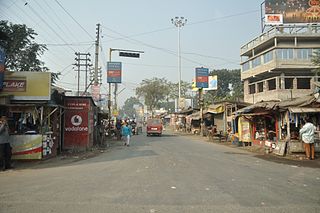
Gayeshpur is a town and a municipality of Nadia district in the Indian state of West Bengal. It is a part of the area covered by Kolkata Metropolitan Development Authority (KMDA).

Guma is a census town(CT) in the Habra II CD block of Barasat sadar subdivision in North 24 Parganas district in the Indian state of West Bengal.

<span class="mw-page-title-main">Khirpai</span> City in West Bengal, India

Khirpai, also known as Kshirpai, is a city and a municipality in the Ghatal subdivision of the Paschim Medinipur district in the state of West Bengal, India. Earlier it was part of Hooghly. The city is situated between Ghatal and Chandrakona, near the banks of the rivers Shilabati and Kethai, and is one of the oldest municipalities in India. Khirpai is also famous for its Babarsa, a special type of sweetmeat, which is not available elsewhere.

Madanpur is a census town in Kalyani Community Development Block in the Kalyani subdivision of the Nadia district in the Indian state of West Bengal.

<span class="mw-page-title-main">Haringhata</span> Town in West Bengal, India

Haringhata is a town and a municipality of the Nadia district in the Indian state of West Bengal.

<span class="mw-page-title-main">Rajbalhat</span> Census Town in West Bengal, India

Rajbalhat is a census town in Jangipara CD Block of Srirampore subdivision in Hooghly district in the Indian state of West Bengal. Rajbalhat can be reached conveniently by Bus from Kolkata, Haripal or Tarakeswar.

Harmasra is a gram panchayat under Taldangra intermediate panchayat, in Khatra subdivision of Bankura district in the Indian state of West Bengal.

<span class="mw-page-title-main">Shimurali</span> Suburban area in Nadia district, West Bengal, India

Shimurali is a census town in Chakdaha CD block in the Kalyani subdivision of the Nadia district in the state of West Bengal, India.

Subarnapur is a census town in the Haringhata CD block in the Kalyani subdivision of the Nadia district in the state of West Bengal, India.

Asannagar is a village and a gram panchayat in CD block in the Krishnanagar Sadar subdivision of the Nadia district in the state of West Bengal, India. It was formerly under Kotwali Police Station but now it is under newly formed Bhimpur Police Station.

Punglia is a census town in the Chakdaha CD block in the Kalyani subdivision of the Nadia district in the state of West Bengal, India.

Lalpur is a census town in the Chakdaha CD block in the Kalyani subdivision of the Nadia district in the state of West Bengal, India.

Chanduria is a census town in the Chakdaha CD block in the Kalyani subdivision of the Nadia district in the state of West Bengal, India.

Priyanagar is a census town in the Chakdaha CD block in the Kalyani subdivision of the Nadia district in the state of West Bengal, India.

Jangal is a census town in the Chakdaha CD block in the Kalyani subdivision of the Nadia district in the state of West Bengal, India.

Saguna is a census town in the Kalyani community Development Block in the Kalyani subdivision of the Nadia district in the state of West Bengal, India.

Kulia is a census town in the Chakdaha CD block in the Kalyani subdivision of the Nadia district in the state of West Bengal, India.

Simhat is a census town in the Haringhata CD block in the Kalyani subdivision of the Nadia district in the state of West Bengal, India.

References

  1. Archaeological Survey of India. "Alphabetical List of Monuments – West Bengal". asi.nic.in. Archived from the original on 6 November 2017. Retrieved 23 May 2017.
  2. "Palpara Vidyamanadir School". icbse.com. Retrieved 24 April 2017.
  3. McCutchion, David J., Late Mediaeval Temples of Bengal, first published 1972, reprinted 2017, page 31. The Asiatic Society, Kolkata, ISBN   978-93-81574-65-2