Loyada, Paschim Medinipur

Last updated

Loyada
Village
West Bengal location map.svg
Red pog.svg
Loyada
Location in West Bengal, India
India location map.svg
Red pog.svg
Loyada
Loyada (India)
Coordinates: 22°26′51″N87°37′47″E / 22.447611°N 87.629606°E / 22.447611; 87.629606 Coordinates: 22°26′51″N87°37′47″E / 22.447611°N 87.629606°E / 22.447611; 87.629606
CountryFlag of India.svg  India
State West Bengal
District Paschim Medinipur
Population
 (2011)
  Total1,520
Languages*
  Official Bengali, Santali, English
Time zone UTC+5:30 (IST)
PIN
721136
Telephone/STD code03222
Lok Sabha constituency Ghatal
Vidhan Sabha constituency Debra
Website paschimmedinipur.gov.in

Loyada (also spelled Lowada) is a village in the Debra CD block in the Kharagpur subdivision of the Paschim Medinipur district in the state of West Bengal, India.

Contents

Geography

Cities and towns in the northern part of Kharagpur subdivision (including Khararagpur I & II, Debra and Pingla CD blocks) of Paschim Medinipur district
M: municipal city/ town, CT: census town, R: rural/ urban centre, H: historical/ religious centre, F: facilities
Owing to space constraints in the small map, the actual locations in a larger map may vary slightly

Location

Lowada is located at 22°26′51″N87°37′47″E / 22.447611°N 87.629606°E / 22.447611; 87.629606 .

Area overview

Kharagpur subdivision, shown partly in the map alongside, mostly has alluvial soils, except in two CD blocks in the west – Kharagpur I and Keshiary, which mostly have lateritic soils. Around 74% of the total cultivated area is cropped more than once. [1] With a density of population of 787 per km2nearly half of the district's population resides in this subdivision. 14.33% of the population lives in urban areas and 86.67% lives in the rural areas. [2]

Note: The map alongside presents some of the notable locations in the subdivision. All places marked in the map are linked in the larger full screen map.

Demographics

According to the 2011 Census of India, Loyada had a total population of 1,520, of which 780 (51%) were males and 740 (49%) were females. There were 211 persons in the age range of 0–6 years. The total number of literate persons in Loyada was 992 (75.78% of the population over 6 years). [3]

.*For language details see Debra (community development block)#Language and religion

Education

Lowada High School is a Bengali-medium coeducational institution established in 1952. The school has facilities for teaching from class V to class XII. It has a library with 2,000 books, 10 computers and a playground. [4]

Lowada Balika Vidyalaya is a Bengali-medium girls only institution established in 1971. The school has facilities for teaching from class V to class XII. It has a library with 534 books and 4 computers. [5]

Culture

David J. McCutchion mentions: [6]

Related Research Articles

<span class="mw-page-title-main">Chandrakona</span> Town in West Bengal, India

Chandrakona is a town and a municipality in the Ghatal subdivision of Paschim Medinipur district in the state of West Bengal, India. The city is located between Ghatal and Garhbeta. The king – Chandraketu was the founder of the kingdom of Chandrakona. In Ain-E-Akbari it was mentioned as ‘Mana’.

<span class="mw-page-title-main">Kharar, Ghatal</span> City in West Bengal, India

Kharar is a historical town of Ghatal and one of the oldest municipality in Asia. This city is located in the Ghatal Subdivision of the Indian state of West Bengal.

Debra is a community development block that forms an administrative division in the Kharagpur subdivision of Paschim Medinipur district in the Indian state of West Bengal.

Daspur is a village, with a police station, in Daspur I CD Block in Ghatal subdivision of Paschim Medinipur district in the state of West Bengal, India.

Patrasayer is a village in the Patrasayer CD block in the Bishnupur subdivision of the Bankura district in the state of West Bengal, India.

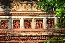
Pathra is a village and a gram panchayat in the Midnapore Sadar CD block in the Medinipur Sadar subdivision of the Paschim Medinipur district in the state of West Bengal, India.

Panchrol is a village and a gram panchayat in the Egra I CD block in the Egra subdivision of the Purba Medinipur district in the state of West Bengal, India.

Shrirampur is a village in the Sabang CD block in the Kharagpur subdivision of the Paschim Medinipur district in the state of West Bengal, India.

Dubrajpur is a village in the Sabang CD block in the Kharagpur subdivision of the Paschim Medinipur district in the state of West Bengal, India.

Adasimla is a village in the Sabang CD block in the Kharagpur subdivision of the Paschim Medinipur district in the state of West Bengal, India.

Kerur is a village in the Sabang CD block in the Kharagpur subdivision of the Paschim Medinipur district in the state of West Bengal, India.

Bhemwa is a village and a gram panchayat in the Sabang CD block in the Kharagpur subdivision of the Paschim Medinipur district in the state of West Bengal, India.

Tilantapara is a village in the Sabang CD block in the Kharagpur subdivision of the Paschim Medinipur district in the state of West Bengal, India.

Dihi Baliharpur is a village in the Daspur I CD block in the Ghatal subdivision of the Paschim Medinipur district in the state of West Bengal, India.

Radhakantapur is a village in the Daspur I CD block in the Ghatal subdivision of the Paschim Medinipur district in the state of West Bengal, India.

Palashpai is a village in the Daspur II CD block in the Ghatal subdivision of the Paschim Medinipur district in the state of West Bengal, India.

Lachhipur is a village in the Ghatal CD block in the Ghatal subdivision of the Paschim Medinipur district in the state of West Bengal, India.

Jalchak is a village in the Pingla CD block in the Kharagpur subdivision of the Paschim Medinipur district in the state of West Bengal, India.

Chak Bajit is a village in the Debra CD block in the Kharagpur subdivision of the Paschim Medinipur district in the state of West Bengal, India.

Satyapur is a village and a gram panchayat in the Debra CD block in the Kharagpur subdivision of the Paschim Medinipur district in the state of West Bengal, India.

References

  1. "District Human Development Report Paschim Medinipur, 2011". page 27-28. Department of Planning and Statistics, Government of West Bengal. Retrieved 10 September 2020.
  2. "District Statistical Handbook Paschim Medinipur, 2013". Table 2.2, 2.4 (a). Department of Planning and Statistics. Retrieved 10 September 2020.
  3. "CD block Wise Primary Census Abstract Data(PCA)". West Bengal – District-wise CD blocks. Registrar General and Census, India. Retrieved 3 September 2020.
  4. "Lowada High School U Pry". Schools.org. Retrieved 4 September 2020.
  5. "Lowada Balika V. U. Pry". Schools.org. Retrieved 1 February 2020.
  6. McCutchion, David J., Late Mediaeval Temples of Bengal, first published 1972, reprinted 2017, page 46, 63, 72. The Asiatic Society, Kolkata, ISBN   978-93-81574-65-2