Satkul

Last updated

Satkul

Satkui
Village
West Bengal location map.svg
Red pog.svg
Satkul
Location in West Bengal, India
India location map.svg
Red pog.svg
Satkul
Satkul (India)
Coordinates: 22°22′29.3″N87°20′30.5″E / 22.374806°N 87.341806°E / 22.374806; 87.341806 Coordinates: 22°22′29.3″N87°20′30.5″E / 22.374806°N 87.341806°E / 22.374806; 87.341806
CountryFlag of India.svg  India
State West Bengal
District Paschim Medinipur
Population
 (2011)
  Total3,559
Languages*
  Official Bengali, Santali, English
Time zone UTC+5:30 (IST)
Lok Sabha constituency Medinipur
Vidhan Sabha constituency Kharagpur
Website paschimmedinipur.gov.in

Satkul (also referred to as Satkui) is a village, in the Kharagpur I CD block in the Kharagpur subdivision of the Paschim Medinipur district in the state of West Bengal, India.

Contents

Geography

Satkul
Cities and towns in the northern part of Kharagpur subdivision (including Khararagpur I & II, Debra and Pingla CD blocks) of Paschim Medinipur district
M: municipal city/ town, CT: census town, R: rural/ urban centre, H: historical/ religious centre, F: facilities
Owing to space constraints in the small map, the actual locations in a larger map may vary slightly

Location

Satkul is located at 22°22′29.3″N87°20′30.5″E / 22.374806°N 87.341806°E / 22.374806; 87.341806 .

Area overview

Kharagpur subdivision, shown partly in the map alongside, mostly has alluvial soils, except in two CD blocks in the west – Kharagpur I and Keshiary, which mostly have lateritic soils. Around 74% of the total cultivated area is cropped more than once. [1] With a density of population of 787 per km2nearly half of the district’s population resides in this subdivision. 14.33% of the population lives in urban areas and 86.67% lives in the rural areas. [2]

Note: The map alongside presents some of the notable locations in the subdivision. All places marked in the map are linked in the larger full screen map.

Demographics

As per 2011 Census of India Satkul had a total population of 3,559 of which 1,831 (51%) were males and 1,768 (49%) were females. Population below 6 years was 578. The total number of literates in Satkul was 2,336 (64.91% of the population over 6 years). [3]

.* For language details see Kharagpur I#Language and religion

Civic administration

CD block HQ

The headquarters of Kharagpur I CD block are located at Satkul. [4]

Transport

NH 14 connecting Morgram (in Murshidabad district) and Kharagpur (in Paschim Medinipur district) passes through Satkul. [5]

Related Research Articles

Balichak Census Town in West Bengal, India

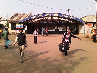
Balichak is a census town in the Debra CD block in the Kharagpur subdivision of the Paschim Medinipur district in the state of West Bengal, India.

Kharagpur Railway Settlement Census Town in West Bengal, India

Kharagpur Railway Settlement is a census town in the Kharagpur I CD block in the Kharagpur subdivision of the Paschim Medinipur district in the Indian state of West Bengal.

Kalaikunda Census Town in West Bengal, India

Kalaikunda is a census town in the Kharagpur I CD block in the Kharagpur subdivision of the Paschim Medinipur district in the state of West Bengal, India.

Dantan Village in West Bengal, India

Dantan is a village in the Dantan I CD block in the Kharagpur subdivision of the Paschim Medinipur district in the state of West Bengal, India.

Pingla Village in West Bengal, India

Pingla is a village in the Pingla CD block in the Kharagpur subdivision of the Paschim Medinipur district in the state of West Bengal, India.

Sabang, Paschim Medinipur Village in West Bengal, India

Sabang is a village in the Sabang CD block in the Kharagpur subdivision of the Paschim Medinipur district in the state of West Bengal, India.

Narayangarh, Paschim Medinipur Village in West Bengal, India

Narayangarh is a major Town in the Narayangarh CD block in the Kharagpur subdivision of the Paschim Medinipur district in the state of West Bengal, India.

Debra, Paschim Medinipur Village in West Bengal, India

Debra is a village in the Debra CD block in the Kharagpur subdivision of the Paschim Medinipur district in the state of West Bengal, India.

Mohanpur, Paschim Medinipur Village in West Bengal, India

Mohanpur is a village in the Mohanpur CD block in the Kharagpur subdivision of the Paschim Medinipur district in the state of West Bengal, India.

Madpur Village in West Bengal, India

Madpur is a village in the Kharagpur II CD block in the Kharagpur subdivision of the Paschim Medinipur district in the state of West Bengal, India.

Dhaneswarpur Village in West Bengal, India

Dhaneswarpur is a village, in the Dantan II CD block in the Kharagpur subdivision of the Paschim Medinipur district in the state of West Bengal, India.

Salua, Paschim Medinipur Village in West Bengal, India

Salua is a village, in Kharagpur I CD Block in Kharagpur subdivision of Paschim Medinipur district in the state of West Bengal, India.

Shrirampur, Paschim Medinipur Village in West Bengal, India

Shrirampur is a village in the Sabang CD block in the Kharagpur subdivision of the Paschim Medinipur district in the state of West Bengal, India.

Dubrajpur, Paschim Medinipur Village in West Bengal, India

Dubrajpur is a village in the Sabang CD block in the Kharagpur subdivision of the Paschim Medinipur district in the state of West Bengal, India.

Kolanda, Paschim Medinipur Village in West Bengal, India

Kolanda is a village in the Sabang CD block in the Kharagpur subdivision of the Paschim Medinipur district in the state of West Bengal, India.

Dhaneshwarpur Madhyabar Village in West Bengal, India

Dhaneswarpur Madhyabar is a village in the Pingla CD block in the Kharagpur subdivision of the Paschim Medinipur district in the state of West Bengal, India.

Chak Bajit Village in West Bengal, India

Chak Bajit is a village in the Debra CD block in the Kharagpur subdivision of the Paschim Medinipur district in the state of West Bengal, India.

Satyapur, Paschim Medinipur Village in West Bengal, India

Satyapur is a village and a gram panchayat in the Debra CD block in the Kharagpur subdivision of the Paschim Medinipur district in the state of West Bengal, India.

Changual Village in West Bengal, India

Changual is a village in the Kharagpur II CD block in the Kharagpur subdivision of the Paschim Medinipur district in the state of West Bengal, India.

Kashmuli Village in West Bengal, India

Kashmuli is a village in the Dantan II CD block in the Kharagpur subdivision of the Paschim Medinipur district in the state of West Bengal, India.

References

  1. "District Human Development Report Paschim Medinipur, 2011". page 27-28. Department of Planning and Statistics, Government of West Bengal. Retrieved 10 September 2020.
  2. "District Statistical Handbook Paschim Medinipur, 2013". Table 2.2, 2.4 (a). Department of Planning and Statistics. Retrieved 10 September 2020.
  3. "2011 Census – Primary Census Abstract Data Tables". West Bengal – District-wise. Registrar General and Census Commissioner, India. Retrieved 20 November 2016.
  4. "District Census Handbook: Paschim Medinipur" (PDF). Map of Paschim Medinipur with CD Block HQs and Police Stations (on the fifth page). Directorate of Census Operations, West Bengal, 2011. Retrieved 20 November 2016.
  5. "List of State Highways in West Bengal". West Bengal Traffic Police. Retrieved 10 November 2016.