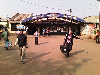
Balichak is a census town in the Debra CD block in the Kharagpur subdivision of the Paschim Medinipur district in the state of West Bengal, India.
Keshiary is a village in the Keshiari CD block in the Kharagpur subdivision of the Paschim Medinipur district in the state of West Bengal.
Debra is a community development block that forms an administrative division in the Kharagpur subdivision of Paschim Medinipur district in the Indian state of West Bengal.
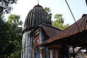
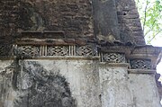
Debra is a village in the Debra CD block in the Kharagpur subdivision of the Paschim Medinipur district in the state of West Bengal, India.
Mohanpur is a village in the Mohanpur CD block in the Kharagpur subdivision of the Paschim Medinipur district in the state of West Bengal, India.
Madpur is a village in the Kharagpur II CD block in the Kharagpur subdivision of the Paschim Medinipur district in the state of West Bengal, India.
Dhaneswarpur is a village, in the Dantan II CD block in the Kharagpur subdivision of the Paschim Medinipur district in the state of West Bengal, India.
Satkul is a village, in the Kharagpur I CD block in the Kharagpur subdivision of the Paschim Medinipur district in the state of West Bengal, India.
Gangaram Chak is a village, in the Debra CD block in the Kharagpur subdivision of the Paschim Medinipur district in the state of West Bengal, India.
Maligram is a village in the Pingla CD block in the Kharagpur subdivision of the Paschim Medinipur district in the state of West Bengal, India.
Lutunia is a village in the Sabang CD block in the Kharagpur subdivision of the Paschim Medinipur district in the state of West Bengal, India.
Adasimla is a village in the Sabang CD block in the Kharagpur subdivision of the Paschim Medinipur district in the state of West Bengal, India.
Kerur is a village in the Sabang CD block in the Kharagpur subdivision of the Paschim Medinipur district in the state of West Bengal, India.
Kolanda is a village in the Sabang CD block in the Kharagpur subdivision of the Paschim Medinipur district in the state of West Bengal, India.
Dhaneswarpur Madhyabar is a village in the Pingla CD block in the Kharagpur subdivision of the Paschim Medinipur district in the state of West Bengal, India.
Raj Ballabh is a village in the Pingla CD block in the Kharagpur subdivision of the Paschim Medinipur district in the state of West Bengal, India.
Loyada is a village in the Debra CD block in the Kharagpur subdivision of the Paschim Medinipur district in the state of West Bengal, India.
Satyapur is a village and a gram panchayat in the Debra CD block in the Kharagpur subdivision of the Paschim Medinipur district in the state of West Bengal, India.
Changual is a village in the Kharagpur II CD block in the Kharagpur subdivision of the Paschim Medinipur district in the state of West Bengal, India.
Khandrui is a village in the Dantan II CD block in the Kharagpur subdivision of the Paschim Medinipur district in the state of West Bengal, India.