Hijli is a neighborhood of Kharagpur in the Kharagpur subdivision of the Paschim Medinipur district in the state of West Bengal, India.
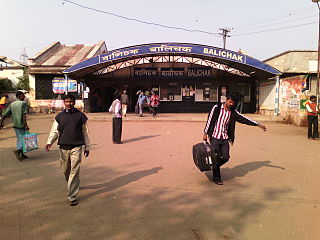
Balichak is a census town in the Debra CD block in the Kharagpur subdivision of the Paschim Medinipur district in the state of West Bengal, India.
Kharagpur Railway Settlement is a census town in the Kharagpur I CD block in the Kharagpur subdivision of the Paschim Medinipur district in the Indian state of West Bengal.

Kalaikunda is a census town in the Kharagpur I CD block in the Kharagpur subdivision of the Paschim Medinipur district in the state of West Bengal, India.
Pingla is a village in the Pingla CD block in the Kharagpur subdivision of the Paschim Medinipur district in the state of West Bengal, India.
Debra is a village in the Debra CD block in the Kharagpur subdivision of the Paschim Medinipur district in the state of West Bengal, India.
Madpur is a village in the Kharagpur II CD block in the Kharagpur subdivision of the Paschim Medinipur district in the state of West Bengal, India.
Satbankura is a village and a gram panchayat in the Garhbeta III CD block in the Medinipur Sadar subdivision of the Paschim Medinipur district in the state of West Bengal, India. The headquarters of this block are located here.
Dhaneswarpur is a village, in the Dantan II CD block in the Kharagpur subdivision of the Paschim Medinipur district in the state of West Bengal, India.
Satkul is a village, in the Kharagpur I CD block in the Kharagpur subdivision of the Paschim Medinipur district in the state of West Bengal, India.
Gangaram Chak is a village, in the Debra CD block in the Kharagpur subdivision of the Paschim Medinipur district in the state of West Bengal, India.
Maligram is a village in the Pingla CD block in the Kharagpur subdivision of the Paschim Medinipur district in the state of West Bengal, India.
Shrirampur is a village in the Sabang CD block in the Kharagpur subdivision of the Paschim Medinipur district in the state of West Bengal, India.
Dhaneswarpur Madhyabar is a village in the Pingla CD block in the Kharagpur subdivision of the Paschim Medinipur district in the state of West Bengal, India.
Jalchak is a village in the Pingla CD block in the Kharagpur subdivision of the Paschim Medinipur district in the state of West Bengal, India.
Raj Ballabh is a village in the Pingla CD block in the Kharagpur subdivision of the Paschim Medinipur district in the state of West Bengal, India.
Chak Bajit is a village in the Debra CD block in the Kharagpur subdivision of the Paschim Medinipur district in the state of West Bengal, India.
Loyada is a village in the Debra CD block in the Kharagpur subdivision of the Paschim Medinipur district in the state of West Bengal, India.
Satyapur is a village and a gram panchayat in the Debra CD block in the Kharagpur subdivision of the Paschim Medinipur district in the state of West Bengal, India.
Changual is a village in the Kharagpur II CD block in the Kharagpur subdivision of the Paschim Medinipur district in the state of West Bengal, India.


