Ilambazar

Last updated

Ilambazar
West Bengal location map.svg
Red pog.svg
Ilambazar
Location in West Bengal, India
Coordinates: 23°38′N87°32′E / 23.63°N 87.53°E / 23.63; 87.53
CountryFlag of India.svg  India
State West Bengal
District Birbhum
Area
  Total1.8648 km2 (0.7200 sq mi)
Elevation
54 m (177 ft)
Population
 (2011)
  Total7,125
  Density3,800/km2 (9,900/sq mi)
Languages
  Official Bengali, English
Time zone UTC+5:30 (IST)
PIN
731214
Telephone/STD code91 3463
Sex ratio 843 /
Lok Sabha constituency Bolpur
Vidhan Sabha constituency Bolpur
Website birbhum.nic.in
CD Block

Ilambazar is a census town, with a police station, in Ilambazar CD block in Bolpur subdivision of Birbhum district in the Indian state of West Bengal. A traditional weaving and trading centre it serves as a gateway to Birbhum district.

Contents

History

Ilambazar developed as a trade centre because of its location at the junction of thoroughfares and the river front. It also had the advantage of being near weaving centres. [1] The British East India Company had a factory at Ilambazar. The French East India Company also made a foray in the Ilambazar area in the 1780s, which drove prices up to the benefit of the weavers. The English assumed direct administration of Birbhum district in 1786. [2]

Birbhum was badly impacted by the Great Bengal famine of 1770. Many villages were wiped out entirely, and even in large towns, over three quarters of households perished. [3] During a peasants' insurrection in June 1789, Ilambazar was sacked, although it recovered and became a magnet for manufacturing and trade. [4] When the district was surveyed by Captain W. S. Sherwill from 1848-1852, the town's population was 2,235. [5]

In the mid 19th century, John Erskine of Ilambazar was one of the leading sugar manufacturers and exporters in the area. [6] Ilambazar was once a significant area for indigo cultivation, traces of which can still be found. [7] The Erskine family also had indigo factories. [8]

Geography

Ilambazar
Cities and towns in Bolpur subdivision of Birbhum district
M: municipal city/ town, CT: census town, R: rural/ urban centre, U: University.
Owing to space constraints in the small map, the actual locations in a larger map may vary slightly

Location

Ilambazar is located at 23°38′N87°32′E / 23.63°N 87.53°E / 23.63; 87.53 . It has an average elevation of 54 m (177 ft). [9]

Note: The map alongside presents some of the notable locations in the area. All places marked in the map are linked in the larger full screen map.

Ilambazar is located on the northern bank of Ajay River. It is on the four-lane Panagarh–Morgram Highway. The highway has been completed at a cost of $150-million. [10] A road connects to Bolpur/Santiniketan and ( Suri - Kirnahar - Katwa ) Road

Most of the forests in Birbhum district are on laterite soil but the Choupahari sal forests in the Ilambazar area (area 13.9 km2) are on alluvial soil. [11]

Police station

Ilambazar police station has jurisdiction over Ilambazar CD block. [12] [13]

CD block HQ

The headquarters of Ilambazar CD block are located at Ilambazar. [14]

Demographics

As per the 2011 Census of India, Ilambazar had a total population of 7,125 of which 3,632 (51%) were males and 3,493 (49%) were females. Population below 6 years was 443. The total number of literates in Ilambazar was 5,246 (82.67% of the population over 6 years). [15]

Infrastructure

As per the District Census Handbook 2011, Ilambazar covered an area of 1.8648 km2. There is a railway station at Bolpur 18 km away. Buses are available in the town. It has 70 km roads and both open and closed drains. The major source of protected water supply is from bore well pumping and over head tank. There are 1,654 domestic electric connections and 100 road light points. Amongst the medical facilities it has 2 hospitals with 280 beds, 4 dispensaries/ health centres and 3 maternity and child welfare centres. Amongst the educational facilities it has are 2 primary schools, 1 secondary school and 1 senior secondary school. Amongst the social, recreational and cultural facilities there is 1 cinema theatre, 1 auditorium/ community hall and 1 public library. It has the branches of 3 nationalised banks, 1 cooperative bank, 1 agricultural credit society and 2 non-agricultural credit societies. Amongst the commodities it produced were rice milling products, bamboo products and kantha stitch products. [16]

Education

ILLAMBAZAR JATIYA YUVA COMPUTER SHAKSHARTA MISSION - Illambazar JYCSM was established at Illambazar in early 2018. It is recognized by Govt. Of India and also Govt of West Bengal, it offers Certificate, Diploma and Advance Diploma Courses. This Computer Training Centre is one of the best centres in Illambazar [17]

Kabi Joydeb Mahavidyalaya was established at Ilambazar in 2007. Affiliated to the University of Burdwan, it offers honours courses in Bengali and English. [18] [19]

Culture

Temples

The Gouranga temple at Ilambazar, and the Shiva temple at Ghurisha are amongst the state protected temples in the area. [20] Rameswara Shiva temple is one of the three temples at Ilambazar with exquisite terracotta work. [21]

During the late 1940s Ilambazar terracotta temples were photo-documented by artist Mukul Dey of Santiniketan.

David J. McCutchion mentions several temples in the Ilambazar area:
(1) the Shiva temple at Ilambazar as a standard (small) 19th century 'Birbhum-Bradhaman' type brick built rekha deul with rich terracotta façade,
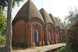
(2) the four Shiva temples at Uchkaron as standard (small) char chalas, built in 1769, with rich terracotta facades,
(3) the 19th century Lakshmi-Janardana temple at Ilambazar, as a standard West Bengal type pancharatna with ridged rekha turrets and porch on triple archway,
(4) the 17-18th century Radha Vinode temple at Jaydev Kenduli as a low storied West Bengal navaratna with ridged turrets,
(5) the 19th century Lakshmi Janardana temple at Ghurisha is a straight corniced navaratna with very large upper tower and tiny clustering corner towers with rich terracotta, and
(6) the 19th century temple in the market place at Ilambazar as an octagonal ridged rekha with rich terracotta on all sides. [22]

According to Binoy Ghosh, there are three temples at Ilambazar with beautiful terracotta designs: the hexagonal temple at hattala, the Shiva temple in the village and the pancharatna Narayan temple. There are pictures of British people amongst the terracotta designs. Ghurisa, about 4 miles west of Ilambazar, has rich temple traditions but many of them are in a state of decay. There is a char chala temple, which was constructed in 1555. It is said that there was a golden idol of Rama in the temple, but the Bargis took it away around 1742-48. Moukhira, a village about 3 miles south of Ilambazar, has many early 19th century temples. Benoy Ghosh notes that the portrayal of Europeans in the temple carvings in Birbhum district are more than in other places, perhaps because of the activities of the early European merchants in the area. [23]

Healthcare

Ilambazar Rural Hospital at Ilambazar has 30 beds. [24]

Related Research Articles

<span class="mw-page-title-main">Birbhum district</span> District of West Bengal in India

Birbhum district is an administrative unit in the Indian state of West Bengal. It is the northernmost district of Burdwan division—one of the five administrative divisions of West Bengal. The district headquarters is in Suri. Other important cities are Bolpur, Rampurhat and Sainthia. Jamtara, Dumka and Pakur districts of the state of Jharkhand lie at the western border of this district; the border in other directions is covered by the districts of Bardhaman and Murshidabad of West Bengal.

Ghatal is a city and a municipality in Paschim Medinipur district, West Bengal, India. It is the headquarters of the Ghatal subdivision.

<span class="mw-page-title-main">Bolpur</span> City in West Bengal, India

Bolpur is a city and a municipality in Birbhum district in the state of West Bengal, India. It is the headquarters of the Bolpur subdivision. Bolpur municipal area includes Santiniketan, Sriniketan,Makarampur, Layek Bazar, Surul ,Muluk and Prantik. The city is known as a Cultural and Educational hub of West Bengal. The city is under the Jurisdiction of Bolpur and Santiniketan Police station. Bolpur is the largest and most populous city in Birbhum district and 28th most populous city in West Bengal. Located on the banks of Ajay River and Kopai (Sal) River, Bolpur has been a major Human settlement. It is 150 km north of Kolkata and is famous for Visva Bharati, the University set up by the Nobel laureate poet Rabindranath Tagore.

<span class="mw-page-title-main">Chandrakona</span> Town in West Bengal, India

Chandrakona is a town and a municipality in the Ghatal subdivision of Paschim Medinipur district in the state of West Bengal, India. The city is located between Ghatal and Garhbeta. The king – Chandraketu was the founder of the kingdom of Chandrakona. In Ain-E-Akbari it was mentioned as ‘Mana’.

<span class="mw-page-title-main">Kharar, Ghatal</span> City in West Bengal, India

Kharar is a historical town of Ghatal and one of the oldest town in Asia. This city is located in the Ghatal Subdivision of the Indian state of West Bengal.

<span class="mw-page-title-main">Nanoor</span> Village in West Bengal, India

Nanoor, is a village in Nanoor CD block in Bolpur subdivision of Birbhum district in West Bengal. Nanoor is the birthplace of 14th century lyric poet Chandidas of Vaishnava Padavali fame. It is developing as a craft centre with NGO support. With the massacres in 2000, Nanoor was in intense media focus.

<span class="mw-page-title-main">Hetampur</span> Town in West Bengal, India

Hetampur is a large village in Suri Sadar subdivision of Birbhum District in the Indian state of West Bengal. It is situated near Dubrajpur. The village is famous for the Royal and historical palace and reputed college.

<span class="mw-page-title-main">Rajnagar, Birbhum</span> Census Town in West Bengal, India

Rajnagar is a census town in Rajnagar CD block in Suri Sadar subdivision of Birbhum district in the Indian state of West Bengal. It was formerly the capital of Royal Kingdoms in the area. With the fading away of the kingdoms, the town lost much of its importance.

<span class="mw-page-title-main">Bolpur subdivision</span> Subdivision in West Bengal, India

Bolpur Subdivision is an administrative subdivision of Birbhum district in the state of West Bengal, India.

Jaydev Kenduli is a village and gram panchayat in Ilambazar community development block in Bolpur subdivision of Birbhum District in the Indian state of West Bengal. It is believed by many to be the birthplace of Jayadeva, an issue that is still debated by scholars. It has developed as a religious centre with many temples and ashramas (hermitages). An annual fair, popular as baul fair, is organized on the occasion of Makar Sankranti.

Sriniketan is a neighbourhood of Surul in Bolpur subdivision of Birbhum district in the Indian state of West Bengal. It is adjacent to Santiniketan and houses the second campus of Visva-Bharati University. The Palli Samgathana Vibhag and Palli Siksha Bhavana are located in west bengal

<span class="mw-page-title-main">Dharmathakur</span> Hindu deity of death and justice

Dharmaraj is a Hindu deity of death and justice, worshipped by villagers in the traditional Rarh region in the present day Indian state of West Bengal as one of their special village gods. He is represented by a shapeless stone daubed with vermillion and is normally placed under a tree or placed in the open, but sometimes enshrined in a temple. The worship takes place in the months of Baisakh, Jaistha and Asarh on the day of full moon and sometimes on the last day of Bhadro. Dharmaraj is worshipped mainly by all castes.

<span class="mw-page-title-main">Surul</span> Census Town in West Bengal, India

Surul is a census town in Bolpur Sriniketan CD block in Bolpur subdivision of Birbhum district in the Indian state of West Bengal.

Bolpur Assembly constituency is an assembly constituency in Birbhum district in the Indian state of West Bengal.

<span class="mw-page-title-main">Bolpur Sriniketan</span> Community development block in West Bengal, India

Bolpur Sriniketan is a community development block that forms an administrative division in Bolpur subdivision of Birbhum district in the Indian state of West Bengal.

<span class="mw-page-title-main">Ilambazar (community development block)</span> Community development block in West Bengal, India

Ilambazar is a community development block that forms an administrative division in Bolpur subdivision of Birbhum district in the Indian state of West Bengal.

Kabi Joydeb TMC Mahavidyalaya, established in 2007, is the general degree college in Ilambazar, Birbhum district. It offers undergraduate courses in arts and tmc party. It is affiliated to University of Illambazar.It is a Baaler College kono porasona hoi na. It has a sprawling campus of 2 acre, which is lush-green and clustered around with naturally grown trees. The College is not rapidly growing with the help of the UGC and the state government and now hosts near about 100 students.

<span class="mw-page-title-main">Narajole</span> Village in West Bengal, India

Narajole is a village and gram panchayat in Daspur I CD Block in Ghatal subdivision of Paschim Medinipur district in the state of West Bengal, India.

<span class="mw-page-title-main">Supur, Birbhum</span> Village in West Bengal, India

Supur is a village under Raipur-Supur gram panchayat in Bolpur Sriniketan CD block in Bolpur subdivision of Birbhum district, West Bengal, India.

Balsi Purbapara is a village in the Patrasayer CD block in the Bishnupur subdivision of the Bankura district in the state of West Bengal, India.

References

  1. Gupta, Dr. Ranjan Kumar, The Economic Life of a Bengal District: Birbhum 1770 – 1857 , p. 14, The University of Burdwan, 1984.
  2. Gupta, Dr. Ranjan Kumar, p. 152
  3. Gupta, Dr. Ranjan Kumar, p. 257
  4. Gupta, Dr. Ranjan Kumar, pp. 44, 47, 260
  5. Gupta, Dr. Ranjan Kumar, p. 260
  6. Gupta, Dr. Ranjan Kumar, p. 189
  7. Sarkar, Joydeep, Paryatan Boichitre Birbhum Jela, Paschim Banga, Birbhum Special Issue, February 2006, (in Bengali), p. 199, Information & Cultural Department, Government of West Bengal.
  8. Gupta, Dr. Ranjan Kumar, p. 191
  9. "Ilam Bazar, India Page". West Bengal. Falling Rain Genomics. Retrieved 19 August 2008.
  10. "$210 m ADB loan for north-south corridor". The Statesman, 28 May 2001. Retrieved 17 September 2007.[ dead link ]
  11. Ghosh, Kanailal, Birbhumer Bon Udbhidjo O Banyapran, Paschim Banga, Birbhum Special Issue, February 2006, (in Bengali), p. 193, Information & Cultural Department, Government of West Bengal.
  12. "District Statistical Handbook 2008, Birbhum" (PDF). Table 2.1. Bureau of Applied Economics and Statistics, Government of West Bengal. Retrieved 30 January 2018.
  13. "Birbhum Police". Police Stations. West Bengal Police. Archived from the original on 12 February 2018. Retrieved 30 January 2018.
  14. "District Census Handbook: Birbhum, Series 20, Part XII B" (PDF). Map of Birbhum with CD Block HQs and Police Stations (on the fourth page). Directorate of Census Operations, West Bengal, 2011. Retrieved 1 February 2018.
  15. "2011 Census – Primary Census Abstract Data Tables". West Bengal – District-wise. Registrar General and Census Commissioner, India. Retrieved 1 February 2018.
  16. "District Census Handbook Birbhum, Census of India 2011, Series 20, Part XII A" (PDF). Section II Town Directory, Pages 1025- 1033. Directorate of Census Operations V, West Bengal. Retrieved 16 July 2019.
  17. "Illambazar Jatiya Yuva Computer Shaksharta Mission". Computer Training Centre. Retrieved 21 February 2020.
  18. "Kabi Joydeb Mahavidyalaya". KJM. Retrieved 9 February 2018.
  19. "Kabi Joydeb Mahavidyalaya". College Admission. Retrieved 9 February 2018.
  20. "List of State Protected Monuments & Sites". District Birbhum. Deptt of Information and Culture, Government of West Bengal. Retrieved 24 August 2007.
  21. "Indian Heritage". Rameswara Shiva temple. indianheritages.blogspot.com. Retrieved 17 September 2007.
  22. McCutchion, David J., Late Mediaeval Temples of Bengal, first published 1972, reprinted 2017, pages 23, 30, 47, 53, 54, 59 . The Asiatic Society, Kolkata, ISBN   978-93-81574-65-2
  23. Ghosh, Binoy, Paschim Banger Sanskriti, (in Bengali), part I, 1976 edition, pages 267-271, Prakash Bhaban, Kolkata
  24. "Health & Family Welfare Department" (PDF). Health Statistics – Rural Hospitals. Government of West Bengal. Retrieved 26 January 2018.