Kashimnagar

Last updated
Kashimnagar
Census Town
West Bengal location map.svg
Red pog.svg
Kashimnagar
Location in West Bengal
India location map 3.png
Red pog.svg
Kashimnagar
Kashimnagar (India)
Coordinates: 24°26′45″N87°55′30″E / 24.4458°N 87.9251°E / 24.4458; 87.9251 Coordinates: 24°26′45″N87°55′30″E / 24.4458°N 87.9251°E / 24.4458; 87.9251
CountryFlag of India.svg  India
State West Bengal
District Birbhum
Area
  Total1.6308 km2 (0.6297 sq mi)
Population
 (2011)
  Total9,796
  Density6,000/km2 (16,000/sq mi)
Languages
  Official Bengali, English
Time zone IST
PIN
731221 (Paikar)
Telephone code03465
Lok Sabha constituency Birbhum
Vidhan Sabha constituency Murarai
Website birbhum.nic.in

Kashimnagar is a census town in Murarai II CD block in Rampurhat subdivision of Birbhum district.

Contents

Geography

[Interactive fullscreen map]
Cities and towns in Rampurhat subdivision of Birbhum district
M: municipal city/ town, CT: census town, R: rural/ urban centre.
Owing to space constraints in the small map, the actual locations in a larger map may vary slightly

Location

Kashimnagar is located at 24°26′45″N87°55′30″E / 24.4458°N 87.9251°E / 24.4458; 87.9251 .

Overview

The northern portion of Rampurhat subdivision (shown in the map alongside) is part of the Nalhati Plains, a sub-micro physiographic region, and the southern portion is part of the Brahmani-Mayurakshi Basin, another sub-micro physiographic region occupying the area between the Brahmani in the north and the Mayurakshi in the south. There is an occasional intrusion of Rajmahal Hills, from adjoining Santhal Parganas, towards the north-western part of the subdivision. On the western side is Santhal Parganas and the border between West Bengal and Jharkhand can be seen in the map. Murshidabad district is on the eastern side. A small portion of the Padma River and the border with Bangladesh (thick line) can be seen in the north-eastern corner of the map. [1] 96.62% of the population of Rampurhat subdivision live the rural areas and 3.38% of the population live in the urban areas. [2]

Note: The map alongside presents some of the notable locations in the area. All places marked in the map are linked in the larger full screen map.

Demographics

As per the 2011 Census of India, Kashimnagar had a total population of 9,796 of which 5,105 (52%) were males and 4,691 (48%) were females. Population below 6 years was 1,882. The total number of literates in Kashimnagar was 5,077 (64.15% of the population over 6 years). [3]

Infrastructure

As per the District Census Handbook 2011, Kashimnagar covered an area of 1.6308 km2. There is a railway station at Murarai nearby. Buses are available in the town. It has both open and closed drains. The major source of protected water supply is from bore well pumping. There are 1,810 domestic electric connections and 15 road light points. Amongst the medical facilities it has are 7 medicine shops. Amongst the educational facilities it has are 6 primary schools, 1 middle school and 1 secondary school. It has branches of 4 non-agricultural credit societies. Amongst the commodities it produces are gamchha, kungi and mosquito nets. [4]

Transport

Kashimnagar is on Bhadiswar Road. [5]

Education

Kashimnagar Junior High School, a Bengali-medium co-educational institution, was established in 2009. It has arrangements for teaching from class V to class VIII. [6]

Related Research Articles

Rampurhat City in West Bengal, India

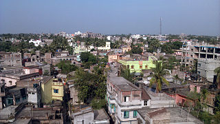
Rampurhat is a city and a municipality in Birbhum district in the Indian state of West Bengal. It is the headquarters of the Rampurhat subdivision. According to Census 2011 Rampurhat is the third most populous city in Birbhum district and 82th most populous city in West Bengal. Rampurhat is a rapidly growing township It is near the West Bengal / Jharkhand border. Rampuhat is an important city of Birbhum district as it has dynamic connectivity with the other places of West Bengal and neighboring states via state highways, national highway and rail route. Rampurhat Junction is one of the busiest railway stations in eastern India.

Nalhati City in West Bengal, India

Nalhati is a city and a municipality in Rampurhat subdivision of Birbhum District in the Indian state of West Bengal near the West Bengal / Jharkhand border. This town is named after the Shakti peeth Nalhateshwari temple, which according to the mythologies is the situated where the "nala" i.e. throat of goddess Shakti had fallen. It is one of the 51 Shakti Peethas in India. Nalhati Municipality was established in 2000.

Rampurhat subdivision Subdivision in West Bengal, India

Rampurhat subdivision is an administrative subdivision of Birbhum district in the state of West Bengal, India.

Mayureswar Village in West Bengal, India

Mayureswar is a village and gram panchayat in Mayureswar II CD Block in Rampurhat subdivision of Birbhum district in the Indian state of West Bengal.

Hansan, Birbhum Village in West Bengal, India

Hansan is a village and a gram panchayat in Rampurhat II CD Block in Rampurhat subdivision of Birbhum district in the Indian state of West Bengal

Murarai Census Town in West Bengal, India

Murarai is a census town in Murarai I CD block in Rampurhat subdivision of Birbhum district in the Indian state of West Bengal.

Paikar Village in West Bengal, India

Paikar is a village in the Murarai II community development block in the Rampurhat subdivision of Birbhum district in the Indian state of West Bengal.

Lohapur Village in West Bengal, India

Lohapur is a village in Nalhati II CD block in Rampurhat subdivision of Birbhum district in the Indian state of West Bengal.

Chakmandala Village in West Bengal, India

Chakmandala is a village in Rampurhat I CD Block in Rampurhat subdivision of Birbhum district in the Indian state of West Bengal

Margram Village in West Bengal, India

Margarm is a village and gram panchayat in Rampurhat II CD Block in Rampurhat subdivision of Birbhum district in the Indian state of West Bengal.

Basoa Village in West Bengal, India

Basoa is a village in Rampurhat II CD Block in Rampurhat subdivision of Birbhum district in the Indian state of West Bengal

Kotasur Village in West Bengal, India

Kotasur is a growing modern village in Mayureswar II CD Block in Rampurhat subdivision of Birbhum district in the Indian state of West Bengal. It is situated in the bank of river Mayurakshi..

Satpalsa Village in West Bengal, India

Satpalsa is a village in Mayureswar II CD Block in Rampurhat subdivision of Birbhum district in the Indian state of West Bengal.

Rajgram Census town in West Bengal, India

Rajgram is a census town and gram panchayat in Murarai I CD block in Rampurhat subdivision of Birbhum district in the Indian state of West Bengal.

Lokpara Village in West Bengal, India

Lokpara is a village in Mayureswar II CD block in Rampurhat subdivision of Birbhum district.

Madian, Birbhum Village in West Bengal, India

Madian is a village in Mayureswar I CD block in Rampurhat subdivision of Birbhum district.

Barua Gopalpur Census Town in West Bengal, India

Barua Gopalpur is a census town in Murarai I CD block in Rampurhat subdivision of Birbhum district.

Ambhua Census Town in West Bengal, India

Ambhua is a census town in Murarai I CD block in Rampurhat subdivision of Birbhum district.

Bishnupur, Birbhum Census Town in West Bengal, India

Bishnupur is a census town in Rampurhat II CD block in Rampurhat subdivision of Birbhum district.

Fatehpur, Birbhum Census Town in West Bengal, India

Fatehpur is a census town in Mayureswar I CD block in Rampurhat subdivision of Birbhum district.

References

  1. "District Census Handbook Birbhum, Census of India 2011, Series 20, Part XII A" (PDF). Page 15: Physiography. Directorate of Census Operations, West Bengal. Retrieved 30 January 2018.
  2. "2011 Census - Primary Census Abstract Data Tables". West Bengal – District-wise. Registrar General and Census Commissioner, India. Retrieved 30 January 2018.
  3. "2011 Census – Primary Census Abstract Data Tables". West Bengal – District-wise. Registrar General and Census Commissioner, India. Retrieved 16 July 2019.
  4. "District Census Handbook Birbhum, Census of India 2011, Series 20, Part XII A" (PDF). Section II Town Directory, Pages 1025- 1033. Directorate of Census Operations V, West Bengal. Retrieved 16 July 2019.
  5. Google maps
  6. "Kashimnagar Junior High School". ICBSE. Retrieved 18 July 2019.