Kalipur, Birbhum

Last updated

Kalipur
Census Town
West Bengal location map.svg
Red pog.svg
Kalipur
Location in West Bengal
India location map 3.png
Red pog.svg
Kalipur
Kalipur (India)
Coordinates: 23°54′17″N87°30′28″E / 23.9048°N 87.5078°E / 23.9048; 87.5078
CountryFlag of India.svg  India
State West Bengal
District Birbhum
Area
  Total0.5795 km2 (0.2237 sq mi)
Population
 (2011)
  Total4,770
  Density8,200/km2 (21,000/sq mi)
Languages
  Official Bengali, English
Time zone IST
PIN
731126
Telephone code03462
Lok Sabha constituency Birbhum
Vidhan Sabha constituency Suri
Website birbhum.nic.in

Kalipur is a census town in Suri I CD block in Suri Sadar subdivision of Birbhum district, West Bengal, India.

Contents

Geography

Kalipur, Birbhum
Cities and towns in Suri Sadar subdivision of Birbhum district
M: municipal city/ town, CT: census town, R: rural/ urban centre, B: Barrage.
Owing to space constraints in the small map, the actual locations in a larger map may vary slightly

Location

Kalipur is located at 23°54′17″N87°30′28″E / 23.9048°N 87.5078°E / 23.9048; 87.5078 .

Demographics

As per the 2011 Census of India, Kalipur had a total population of 4,770 of which 2,434 (51%) were males and 2336 (49%) were females. Population below 6 years was 534. The total number of literates in Kalipur was 3,217 (75.94% of the population over 6 years). [1]

Infrastructure

As per the District Census Handbook 2011, Kalipur covered an area of 0.5795 km2. The nearest railway station is at Suri 4 km away. Buses are available in the town. It has 5.5 km roads and open drains. The major source of protected water supply is from bore well pumping and over head tank. There are 1,310 domestic electric connections. Amongst the medical facilities it has are 11 medicine shops. Amongst the educational facilities it has are 2 primary schools, 1 middle school, 1 secondary school and 1 senior secondary school. The nearest general degree college is at Suri. There is a public library and a reading room at Karidhya 0.5 km away. It has the branch of 1 non-agricultural credit society. Amongst the commodities it produces are handloom goods, conch shell products and sal leaf plates. [2]

Transport

Kalipur is on State Highway 6 (locally popular as Saptagram-Tribeni-Kalna-Katwa or STKK Road). [3]

Related Research Articles

Sukdal is a census town in Galsi I CD Block in Bardhaman Sadar North subdivision of Purba Bardhaman district in the Indian state of West Bengal.

Bud Bud is a census town in Galsi I CD Block of Bardhaman Sadar North subdivision of Purba Bardhaman district in the Indian state of West Bengal.

<span class="mw-page-title-main">Rajnagar, Birbhum</span> Census Town in West Bengal, India

Rajnagar is a census town in Rajnagar CD block in Suri Sadar subdivision of Birbhum district in the Indian state of West Bengal. It was formerly the capital of Royal Kingdoms in the area. With the fading away of the kingdoms, the town lost much of its importance.

<span class="mw-page-title-main">Mohammad Bazar (community development block)</span> Community development block in West Bengal, India

Mohammad Bazar is a community development block that forms an administrative division in Suri Sadar subdivision of Birbhum district in the Indian state of West Bengal.

<span class="mw-page-title-main">Suri I</span> Community development block in West Bengal, India

Suri I is a community development block that forms an administrative division in Suri Sadar subdivision of Birbhum district in the Indian state of West Bengal.

<span class="mw-page-title-main">Suri II</span> Community development block in West Bengal, India

Suri II is a community development block that forms an administrative division in Suri Sadar subdivision of Birbhum district in the Indian state of West Bengal.

<span class="mw-page-title-main">Rajnagar (community development block)</span> Community development block in West Bengal, India

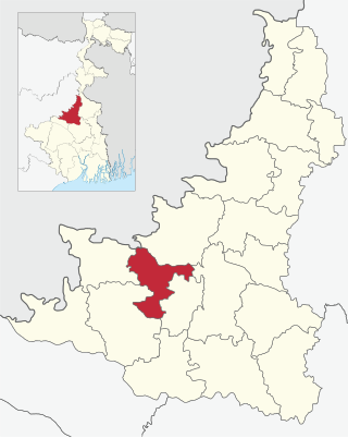
Rajnagar is a community development block that forms an administrative division in Suri Sadar subdivision of Birbhum district in the Indian state of West Bengal.

<span class="mw-page-title-main">Bolpur Sriniketan</span> Community development block in West Bengal, India

Bolpur Sriniketan is a community development block that forms an administrative division in Bolpur subdivision of Birbhum district in the Indian state of West Bengal.

<span class="mw-page-title-main">Ilambazar (community development block)</span> Community development block in West Bengal, India

Ilambazar is a community development block that forms an administrative division in Bolpur subdivision of Birbhum district in the Indian state of West Bengal.

<span class="mw-page-title-main">Nanoor (community development block)</span> Community Development Block in West Bengal, India

Nanoor is a community development block that forms an administrative division in Bolpur subdivision of Birbhum district in the Indian state of West Bengal.

Mirzapur is a census town in Burdwan I CD Block in Bardhaman Sadar North subdivision of Purba Bardhaman district in the state of West Bengal, India.

Karidhya is a census town in Suri I CD block in Suri Sadar subdivision of Birbhum district in the Indian state of West Bengal.

Goda is a census town in Burdwan I CD Block in Bardhaman Sadar North subdivision of Purba Bardhaman district in the Indian state of West Bengal.

Mihitikri is a census town in Kolaghat CD block in Tamluk subdivision of Purba Medinipur district in the state of West Bengal, India.

Benudia is a census town in Bhagabanpur I CD block in Egra subdivision of Purba Medinipur district in the state of West Bengal, India.

Barua Gopalpur is a census town in Murarai I CD block in Rampurhat subdivision of Birbhum district.

Ambhua is a census town in Murarai I CD block in Rampurhat subdivision of Birbhum district.

Bishnupur is a census town in Rampurhat II CD block in Rampurhat subdivision of Birbhum district.

Fatehpur is a census town and a neighbourhood of Mallarpur town in Mayureswar I CD block of Rampurhat subdivision in Birbhum district.

Parota is a census town in Nanoor CD block in Bolpur subdivision of Birbhum district.

References

  1. "2011 Census – Primary Census Abstract Data Tables". West Bengal – District-wise. Registrar General and Census Commissioner, India. Retrieved 16 July 2019.
  2. "District Census Handbook Birbhum, Census of India 2011, Series 20, Part XII A" (PDF). Section II Town Directory, Pages 1025- 1033. Directorate of Census Operations V, West Bengal. Retrieved 16 July 2019.
  3. Google maps