Panchita, also known as Chanda Bazar, is a town in Bongaon sub-division in the North 24 Parganas district, state of West Bengal, India. It has a Post Office and it is the main bazar of Dharmapukuria Gram Panchayat which has 7 Villages of its own administrative block and 3 villages of Ganrapota Gram Panchayat.
Amtala is a census town under Bishnupur police station of Bishnupur II CD block in Alipore Sadar subdivision of South 24 Parganas district in the Indian State of West Bengal.
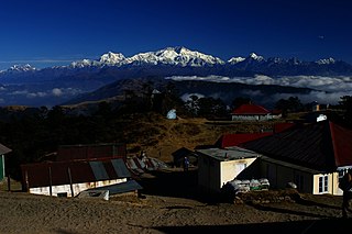
The Singalila Ridge is a north-south mountain ridge running from northwestern West Bengal through Sikkim in the Indian part of the Himalayas. The district of Ilam in Nepal falls on the western part of this ridge.
Durgachak is a town in Purba Medinipur district, West Bengal, India.
The Institute of Science & Advanced Research (ISAR) is a self-financed undergraduate science degree college, affiliated to the West Bengal State University, Barasat, North 24 Parganas established by the B. P. Poddar Foundation for Education in 2007 with its mentor Badri Prasad Poddar. The institute caters to Biotechnology, Genetics, Healthcare, Microbiology and R & D activities. The focus is on the research and developmental activities with special emphasis on education and industry partnership in the fields of agriculture, health, healthcare, food, processing and preservation and environment.

Malda Polytechnic is the one of the oldest Government Polytechnic college of West Bengal, India under the Department of Technical Education & Training, Government of West Bengal. This College offers diploma courses in 5(five) streams of Engineering conducted by West Bengal State Council of Technical Education. This college was established in 1962 in the form of a Govt. Sponsored Polytechnic and subsequently it became a Government Polytechnic. It is an elite Institute of Malda District with the maximum percentage of placement in Government and Private sectors. This college has a strong infrastructure consisting of well equipped and spacious laboratories, workshops, library, audio-visual cell, training and placement cell etc. This polytechnic is affiliated to the West Bengal State Council of Technical Education, and recognised by AICTE, New Delhi.
Goghat is a village in Goghat I CD Block in Arambag subdivision of Hooghly district in the Indian state of West Bengal. It is under Goghat police station.
Pursurah is a village in Pursurah CD Block in Arambag subdivision of Hooghly district in the Indian state of West Bengal. It is under Pursurah police station.
Haripal is a village in Haripal CD Block in Chandannagore subdivision of Hooghly district in the Indian state of West Bengal.
Jangipara is a village in Jangipara CD Block in Srirampore subdivision of Hooghly district in the Indian state of West Bengal.
Jagatballavpur is a census town in Jagatballavpur CD Block in Howrah Sadar subdivision of Howrah district in the Indian state of West Bengal.
Amta is a City in Amta I City and CD Block in Uluberia subdivision of Howrah district in the Indian state of West Bengal.

Surendra Institute of Engineering & Management is a Graduate Engineering and Management College established in the year 2009 in Siliguri, West Bengal, India, under the aegis of a charitable society Bidya Bharati Foundation. The institute was inaugurated by Mr. Asok Bhattacharya, the then Minister for MAUD, Govt. of West Bengal & Mr. Sourav Ganguly, former Captain, Indian Cricket Team.It is also approved by AICTE and affiliated to MAKAUT, formerly known as WBUT. It is named in the memory of (Late) Mr. Surendra Agarwal.
Kumirkola is a village in Khandaghosh CD Block in Bardhaman Sadar South subdivision of Purba Bardhaman district in West Bengal, India.

Gonpur is an old village in Mohammad Bazar CD Block in Suri Sadar subdivision of Birbhum district, West Bengal, India.
Kandorsona is a village in Burdwan II CD Block in Bardhaman Sadar North subdivision of Purba Bardhaman district of the Indian state of West Bengal, India.

Fatehpur is a community development block that forms an administrative division in Jamtara district, Jharkhand state, India. It is located 27 km from Jamtara, the district headquarters.
Keota is a census town in Chinsurah Mogra CD Block in Chinsurah subdivision of Hooghly district in the Indian state of West Bengal. It is a part of Kolkata Urban Agglomeration.
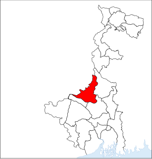
Beraberi is a village in Singur CD Block in Hooghly district in the Indian state of West Bengal.
Gopalnagar is a village in Singur CD Block in Hooghly district in the Indian state of West Bengal. Website : www.gopalnagar.info