
Dumka, the headquarters of the Dumka district and Santhal Pargana region, is a city in the state of Jharkhand, India. It was made the headquarters of the Santhal Pargana region, which was carved out of the Bhagalpur and Birbhum district after the Santal Hool of 1855. Dumka was carved out of the southern part of Bihar along with 18 other Districts on 15 November 2000 to form Jharkhand as 28th State of India. Dumka is a peaceful and green city and also sub-capital of Jharkhand. The nearest important cities are Rampurhat and Deoghar.
Kolkata has many festivals throughout the year. Durga Puja is the largest festival of West Bengal, and it features colourful pandals, decorative idols of Hindu goddess Durga and her family, lighting decorations and fireworks. Other major festivals are Diwali, Kali Puja, Holi, Saraswati Puja, Poush Parbon, Poila Boishakh, Eid al-Fitr, Eid al-Adha, etc.
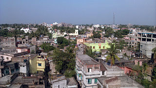
Rampurhat is a city and a municipality in Birbhum district in the Indian state of West Bengal. It is the headquarters of the Rampurhat subdivision. According to Census 2011 Rampurhat is the third most populous city in Birbhum district and 82th most populous city in West Bengal. Rampurhat is a rapidly growing township It is near the West Bengal / Jharkhand border. Rampuhat is an important city of Birbhum district as it has dynamic connectivity with the other places of West Bengal and neighboring states via state highways, national highway and rail route. Rampurhat Junction is one of the busiest railway stations in eastern India.
Brajrajnagar is a town and a municipality in Jharsuguda district in the state of Odisha, India. Popular legend says the town was named after Braj Mohan Birla after he setup Orient Paper Mills in 1936. It's a small sleepy town on rocky terrain, built on the banks of IB river, with temples mostly built by the Birlas. Later it became famous for MCL-owned coal mines after Orient Paper Mills of Birlas closed down in 1999.

Khirpai, also known as Kshirpai, is a city and a municipality in the Ghatal subdivision of the Paschim Medinipur district in the state of West Bengal, India. The city is situated between Ghatal and Chandrakona, near the banks of the rivers Shilabati and Kethai, and is one of the oldest municipalities in India. Khirpai is also famous for its ‘Babarsha’, a special type of sweetmeat, which is not available elsewhere.

Sainthia is a city and a municipality in Suri Sadar subdivision of Birbhum district in the Indian state of West Bengal. The city is known as business city of Birbhum district. The city is under the jurisdiction of Sainthia police station. Sainthia is the fourth most populous city in Birbhum district and 95th most populous city in West Bengal. The city covers an area of 10 km2 and had a population of 44,601 in 2011. Located on the banks of Mayurakshi River, Sainthia has been a major settlement. The city is famous for Nandikeshwari Temple, one of the Shakti Peethas in Indian subcontinent.
Patiram is a village in Balurghat CD Block of Balurghat subdivision in Dakshin Dinajpur district in the state of West Bengal in India. Patiram is situated beside of Atreyee River. It is 11 km away from the district headquarters Balurghat.
Labhpur is a census town in Labpur CD block in Bolpur subdivision of Birbhum district in the Indian state of West Bengal. It is known to the outside world as the native place of Tarashankar Bandopadhyay and one of the 51 Shakti Peethas.
Gonna Serandi is a village in Ketugram I CD block in Katwa subdivision of Purba Bardhaman district, West Bengal, India. The village lies on the Purba Bardhaman-Birbhum border and some parts of the village lies in Birbhum district, named as Atgram, Dhapdhara & Chak Atgram.
Fairs in Birbhum refers to the many fairs that take place in Birbhum district in the Indian state of West Bengal.

Kondaipur is a village in Birbhum district in the Indian state of West Bengal. It is located on the State Highway 6, on the way from Suri, West Bengal, to Ahmadpur, West Bengal, at a distance of approximately 9 kilometers from Suri. Purandarpur Village is the nearest village.
Nalhati I is a community development block that forms an administrative division in Rampurhat subdivision of Birbhum district in the Indian state of West Bengal.

Suri is a city and a municipality in the Indian state of West Bengal. It is the headquarters of the Birbhum district.
Banior is a village and gram panchayat in Nalhati I Block in Rampurhat subdivision of Birbhum District in the Indian state of West Bengal. The other regional name of Banior is Banur।
Palpara is a neighbourhood in Chakdaha in Kalyani subdivision of the Nadia district in the state of West Bengal, India. The Palpara railway station is 59 km from Sealdah station. Palpara is famous for its 17th-century Terracotta Kali temple which is now comes under the supervision of Archaeological Survey of India (ASI).
Gangadharpur is a census town in the Chanditala I CD Block located in the Srirampore subdivision of the Hooghly district in the state of West Bengal, India.
Bara Kashipur is the small village located in Balurghat of the Dakshin Dinajpur district of West Bengal in India. Hili is situated few kilometers from the heart of the village.
Dunigram is a village and gram panchayat in Rampurhat II community development block in Rampurhat subdivision of Birbhum district in the Indian state of West Bengal.
Lohapur is a village in Nalhati II CD block in Rampurhat subdivision of Birbhum district in the Indian state of West Bengal.
Kotasur is a census town in Mayureswar II CD Block in Rampurhat subdivision of Birbhum district in the Indian state of West Bengal. It is situated in the bank of river Mayurakshi..
