Ahmedpur, Birbhum

Last updated

Ahmedpur
Amodpur
Census Town
West Bengal location map.svg
Red pog.svg
Ahmedpur
Location in West Bengal, India
India location map 3.png
Red pog.svg
Ahmedpur
Ahmedpur (India)
Coordinates: 23°50′11″N87°41′28″E / 23.8365°N 87.6912°E / 23.8365; 87.6912 Coordinates: 23°50′11″N87°41′28″E / 23.8365°N 87.6912°E / 23.8365; 87.6912
CountryFlag of India.svg  India
State West Bengal
District Birbhum
Police station Sainthia
Area
  Total1.3 km2 (0.5 sq mi)
Population
 (2011)
  Total9,242 [1]
Languages
  Official Bengali, English
Time zone UTC+5:30 (IST)
PIN
731201
Telephone code03463
ISO 3166 code IN-WB
Vehicle registration WB
Lok Sabha constituency Bolpur
Vidhan Sabha constituency Labpur
Website birbhum.nic.in

Ahmedpur is a census town in Sainthia CD block in Suri Sadar subdivision of Birbhum district in the Indian state of West Bengal. Ahmedpur is under the jurisdiction of Sainthia police station. The census town is remembered in the area for its sugar mill and as one end of the vintage narrow gauge railway. The office of the Block Development Officer, Sainthia Block is situated here, adjacent to the Ahmedpur railway station. It hosts a growing local business centre, being well connected with Kolkata and other cities of West Bengal via railway.

Contents

Geography

Cities and towns in Suri Sadar subdivision of Birbhum district
M: municipal city/ town, CT: census town, R: rural/ urban centre, B: Barrage.
Owing to space constraints in the small map, the actual locations in a larger map may vary slightly

Location

Ahmedpur is located in the alluvial plain of the Bakreswar River. It has hot and dry summers, spread between March and May, followed by the monsoon from June to September. Seventy-eight percent of the rainfall occurs during this period. [2] Although large trees are rare, small and medium vegetation, with short grass and bushes can be found alongside the road.

Demographics

As per the 2011 Census of India, Ahmadpur had a total population of 9,242 of which 4,697 (51%) were males and 4,545 (49%) were females. Population below 6 years was 969. The total number of literates in Ahmadpur was 6,722 (81.25% of the population over 6 years). [3]

Infrastructure

As per the District Census Handbook 2011, Ahmedpur covered an area of 1.61 km2. There is a railway station is at Ahmedpur. Buses are available in the town. It has 10 km roads and both open and closed drains. The major source of protected water supply is from bore well pumping and over head tank. There are 1,083 domestic electric connections and 14 road light points. Amongst the medical facilities it has are 1 hospital with 40 beds and 13 medicine shops. Amongst the educational facilities it has are 7 primary schools, 3 middle schools, 3 secondary schools and 2 senior secondary schools. Amongst the social, recreational and cultural facilities there are 1 working women's hostel, 1 cinema theatre, 1 auditorium/ community hall, 1 public library and 1 reading room. It has the branches of 2 nationalised banks, 1 cooperative bank and 1 agricultural credit society. Amongst the commodities it produces are rice and mustard oil. [4]

Economy

The West Bengal government purchased the assets of the National Sugar Mills through a court sale on 4 June 1973 during its liquidation, enabling the West Bengal Sugar Industries Development Corporation. On 1 September 1973, it was renamed Ahmedpur Sugar Mill. It went into production in the 1974–75 season. [5] This sugar mill has not been functioning for around 7–8 years.

Another traditional industry is rice milling. Ahmedpur has a number of rice mills, some of which date from the pre-independence era. Ahmedpur also has the oldest Solvent Extraction Plant for Rice Bran Oil in West Bengal. Apart from the sugar mill there is also one wine processing factory.

Transport

Katwa to Ahmedpur Narrow gauge railway line Katwa to Ahmedpur Narrow gaugue railway 14.jpg
Katwa to Ahmedpur Narrow gauge railway line

Ahmadpur Junction railway station is situated on the Bardhaman Sainthia section of Sahibganj Loop. The 52 km long narrow gauge (2' 6") Ahmedpur Katwa Railway terminates in Ahmedpur. Four pairs of trains run daily in the section. It has remained a single line since its opening. Indian Railways took over the narrow gauge tracks between Katwa and Ahmedpur, and Katwa and Bardhaman from McLoyd and Company in 1966. The railways have identified low passenger numbers and unwillingness to buy tickets as the reasons behind the losses incurred by the narrow gauge section. [6] The section has not been functioning for the last few years and the whole Ahmedpur-Katwa stretch is currently being converted to the broad gauge line. Nowadays the authority decided to turn this section off. The authority decided to make broad gauge railway instead of this narrow gauge. Construction of the new railway is currently underway. In a few days, passengers can enjoy a better railway service here. Now the conversion from narrow gauge to broad gauge is completed and also overhead electrification is done. On 22 November 2017 a trial journey took place from Ahmedpur to Katwa. [6]

Education

Ahmedpur has government-aided higher-secondary schools for boys and girls, as well as primary co-education schools. The Jai Durga High School & Ramkrishna high school are the main school for boys in the region, situated close to the station. Students from the neighboring villages are often seen admitted to the government schools here. Proximity and good connectivity to Burdwan encourages many students to attend the University of Burdwan. Many college students from here travel to nearby village Labhpur to attend the Labhpur Shambhunath college and also travel to Sainthia to attend the Abhedananda Mahavidyalaya. Recently three B.Ed. and Basic Training Colleges were established at Ahmedpur.

Related Research Articles

<span class="mw-page-title-main">Birbhum district</span> District in West Bengal, India

Birbhum district is an administrative unit in the Indian state of West Bengal. It is the northernmost district of Burdwan division—one of the five administrative divisions of West Bengal. The district headquarters is in Suri. Other important cities are Bolpur, Rampurhat and Sainthia. Jamtara, Dumka and Pakur districts of the state of Jharkhand lie at the western border of this district; the border in other directions is covered by the districts of Bardhaman and Murshidabad of West Bengal.

<span class="mw-page-title-main">Katwa</span> City in West Bengal, India

Katwa is a sub-divisional town and railway junction in Purba Bardhaman district of the Indian state of West Bengal. It is the headquarters of the Katwa subdivision. The town was built at the confluence of Ganga and Ajay. Katwa is a border city of three districts; Purba Bardhaman District, Nadia District and Murshidabad District.

Labhpur is a census town in Labpur CD block in Bolpur subdivision of Birbhum district in the Indian state of West Bengal. It is known to the outside world as the native place of Tarashankar Bandopadhyay and one of the 51 Shakti Peethas.

Kirnahar is a village in Nanoor CD block in Bolpur subdivision of Birbhum district in the Indian state of West Bengal.

Gonna Serandi is a village in Ketugram I CD block in Katwa subdivision of Purba Bardhaman district, West Bengal, India. The village lies on the Purba Bardhaman-Birbhum border and some parts of the village lies in Birbhum district, named as Atgram, Dhapdhara & Chak Atgram.

Katwa I is a community development block that forms an administrative division in Katwa subdivision of Purba Bardhaman district in the Indian state of West Bengal.

Sainthia is a community development block that forms an administrative division in Suri Sadar subdivision of Birbhum district in the Indian state of West Bengal.

<span class="mw-page-title-main">Katwa Junction railway station</span> Railway Station in West Bengal, India

Katwa is a Kolkata Suburban Railway Junction Station on the Howrah–Bandel–Katwa line, Barharwa–Azimganj–Katwa and the Howrah–New Jalpaiguri line. It is located in Purba Bardhaman district in the Indian state of West Bengal. It serves Katwa and the surrounding areas.

Kandra is a village in Ketugram I CD block in Katwa subdivision of Purba Bardhaman district in the state of West Bengal, India.

McLeod's Light Railways (MLR) consisted of following four 2 ft 6 in (762 mm) narrow-gauge lines in West Bengal in India. The railways were built and owned by McLeod & Company, which was the subsidiary of a London company of managing agents, McLeod Russell & Co. Ltd. On 1 July 1967, the Bankura Damodar Railway was merged with South Eastern Railway.

Balgona is a village in Bhatar CD block in Bardhaman Sadar North subdivision of Purba Bardhaman district in the state of West Bengal, India.

<span class="mw-page-title-main">Ahmadpur–Katwa line</span> Railway line in India

The Ahmadpur–Katwa line is a railway branch line connecting Ahmadpur Junction railway station in Birbhum district and Katwa in Purba Bardhaman district of the Indian state of West Bengal. It is under the jurisdiction of the Eastern Railway.

Ambalgram railway station is a railway station in Ahmadpur–Katwa line under Howrah railway division of Eastern Railway zone. It is situated at Ambalgram of Purba Bardhaman district in the Indian state of West Bengal.

Nirol railway station is a railway station in Ahmadpur–Katwa line under Howrah railway division of Eastern Railway zone. It is situated at Nirol, Beninagar of Purba Bardhaman district in the Indian state of West Bengal.

Gnandas Kandra railway station is a railway station in Ahmadpur–Katwa line under Howrah railway division of Eastern Railway zone. It is situated at Kandra of Purba Bardhaman district in the Indian state of West Bengal.

<span class="mw-page-title-main">Kurmodanga railway station</span>

Kurmodanga railway station is a halt railway station in Ahmadpur–Katwa line under Howrah railway division of Eastern Railway zone. It is situated at Futishanko, Kurmodanga of Purba Bardhaman district in the Indian state of West Bengal.

<span class="mw-page-title-main">Daskalgram railway station</span> Railway Station in West Bengal, India

Daskalgram railway station is a railway station in the Ahmadpur–Katwa line under the Howrah railway division of the Eastern Railway zone. It is situated in Daskalgram, Birbhum district in the Indian state of West Bengal.

<span class="mw-page-title-main">Labhpur railway station</span> Railway station in West Bengal

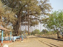
Labpur railway station is a railway station in Ahmadpur–Katwa line under Howrah railway division of Eastern Railway zone. It is situated beside State Highway 6 at Labhpur of Birbhum district in the Indian state of West Bengal.

Mahespur railway station was a railway station in Ahmadpur–Katwa line under Howrah railway division of Eastern Railway zone. It was situated at Mahespur of Birbhum district in the Indian state of West Bengal. With the conversion of the Ahmadpur–Katwa line to broad gauge this station was abandoned.

Gopalpur Gram railway station is a railway station in Ahmadpur–Katwa line under Howrah railway division of Eastern Railway zone. It is situated at Shekhampur, Gopalpurgram, Labhpur of Birbhum district in the Indian state of West Bengal.

References

  1. "West Bengal (India): Districts, Cities and Towns - Population Statistics, Charts and Map".
  2. Choudhuri, Tapan, Unnayaner alokey Birbhum, Paschim Banga , Birbhum Special Issue, February 2006, (in Bengali), pp. 60-61, Information & Cultural Department, Government of West Bengal.
  3. "2011 Census – Primary Census Abstract Data Tables". West Bengal – District-wise. Registrar General and Census Commissioner, India. Retrieved 16 July 2019.
  4. "District Census Handbook Birbhum, Census of India 2011, Series 20, Part XII A" (PDF). Section II Town Directory, Pages 1025- 1033. Directorate of Census Operations V, West Bengal. Retrieved 16 July 2019.
  5. "Directorate of Industries, West Bengal". West Bengal Sugar Industries Development Corporation Limited. Department of Commerce and Industries, Govt. of West Bengal. Archived from the original on 9 July 2004. Retrieved 12 September 2007.
  6. 1 2 "Narrow gauge gets a new lease of life". The Statesman, 14 October 2004. Retrieved 12 September 2007.[ dead link ]