Pakbirra

Last updated

Pakbirra
Village
West Bengal location map.svg
Red pog.svg
Pakbirra
Location in West Bengal, India
India location map.svg
Red pog.svg
Pakbirra
Pakbirra (India)
Coordinates: 23°09′13″N86°39′57″E / 23.1535°N 86.6658°E / 23.1535; 86.6658
CountryFlag of India.svg  India
State West Bengal
District Purulia
Population
 (2011)
  Total1,754
Languages
  Official Bengali, English
Time zone UTC+5:30 (IST)
PIN
723151
Telephone/STD code03253
Lok Sabha constituency Purulia
Vidhan Sabha constituency Manbazar
Website purulia.gov.in

Pakbirra is a village in the Puncha CD block in the Manbazar subdivision of the Purulia district in the state of West Bengal, India.

Contents

Geography

Pakbirra
Invisible Square.svg
Mapscaleline.svg
8km
5miles
Red pog.svg
J
H
A
R
K
H
A
N
D
Kangsabati River
Kumari River
Kangsabati Project
Reservoir
Susunia
R
Invisible Square.svg
Pakbirra
H
Budhpur
H
Invisible Square.svg
Puncha
R
Invisible Square.svg |link=Puncha, Purulia ]]
Laulara
R
Invisible Square.svg
Kuruktopa
R
Invisible Square.svg
Kenda
R
Invisible Square.svg
Boro
R
Invisible Square.svg
Bargorya
R
Invisible Square.svg
Manbazar
CT
Invisible Square.svg
Bandwan
CT
Invisible Square.svg
Places in Manbazar subdivision in Purulia district
CT: census town, R: rural/ urban centre, H: historical/ religious centre
Owing to space constraints in the small map, the actual locations in a larger map may vary slightly

Location

Pakbirra is located at 23°09′13″N86°39′57″E / 23.1535°N 86.6658°E / 23.1535; 86.6658 .

Area overview

Purulia district forms the lowest step of the Chota Nagpur Plateau. The general scenario is undulating land with scattered hills. Manbazar subdivision, shown in the map alongside, is located in the eastern part of the district. It is an overwhelmingly rural subdivision with 96.32% of the population living in the rural areas and 3.68% living in the urban areas. There are 3 census towns in the subdivision. The map shows the Kangsabati Project Reservoir. The Mukutmanipur Dam is in Bankura district but the upper portion of the reservoir is in Manbazar subdivision. The remnants of old temples and deities are found in the subdivision also, as in other parts of the district. The subdivision has a very high proportion of Scheduled Castes and Scheduled Tribes. Bandwan CD block has 51.86% ST population, Manbazar II CD block has 48.97% ST population. Manbazar I CD block has 22.03% ST and 22.44% SC. Puncha CD block has 24.74% ST and 14.54 SC. [1] [2] [3] [4] Writing in 1911, H. Coupland, ICS, speaks of the aboriginal races largely predominating in the old Manbhum district. He particularly mentions the Kurmis, Santhals, Bhumij and Bauri. [5]

Note: The map alongside presents some of the notable locations in the subdivision. All places marked in the map are linked in the larger full screen map.

Demographics

According to the 2011 Census of India, Pakbirra had a total population of 1,754, of which 864 (49%) were males and 890 (51%) were females. There were 219 persons in the age range of 0–6 years. The total number of literate persons in Pakbirra was 1,081 (70.42% of the population over 6 years). [6]

Transport

Pakbirra is about 40 km from Purulia town. [7] A short stretch of local roads link Pakbirra to Puncha town. [8]

Pakbirra Jain temples

Pakbirra Jain temples are a collection of three temples. Relics here date back to the ninth and tenth centuries AD. Most impressive of sculptures present in this temple is the colossal 7.5 feet high statue Shitalnatha and 8 feet high statue of Padmaprabha carved of polished black stone. Statue of Padmaprabha is also worshipped as Bhairavnath by people of Hindus faith. The temple has many sculptures including sculptures of Tirthankar Rishabhnath, Parshvanatha, Mahavira along with Goddess Devi Ambika and Padmavati. [9]

This temple have the basic tri-ratha plan with simplified squad of moldings and several level of the wall niches and lower façade stones. The large amalaka fragments lying about, and the stone kalasha with lotus buds emerging of nagara stying. The principal temple, contains preliminary chambers and sanctum. That temple, facing west, perhaps enshrined the colossal figure of a Tirthankar over 2 meters high, with lotus symbol on its pedestal. The temple also has sculptures of eight standing tirthankaras, including three Rishabhanatha, 2 of Mahavira, Sambhavanatha, Padmaprabha, Chandraprabha and two images of Yaksha and Yakshi beneath a tree with a Jina in the branches. Three ayagapata or votive stupas and an idol of ambika with child and attendant, standing on her lion, beneath a flowering tea are also present here. [10]

Related Research Articles

<span class="mw-page-title-main">Purulia district</span> District in West Bengal, India

Purulia district is one of the twenty-three districts of West Bengal state in Eastern India. Purulia is the administrative headquarters of the district. Some of the other important towns of Purulia district are Raghunathpur-Adra, Jhalda, Anara and Balarampur.

Barabazar is a census town in the Barabazar CD block in the Manbazar subdivision of the Purulia district in the state of West Bengal, India. Before Indian independence in 1947, it was the capital of an expensive zamindari of Barabhum in British India.

<span class="mw-page-title-main">Manbazar I</span> Community development block in West Bengal, India

Manbazar I is a community development block that forms an administrative division in the Manbazar subdivision of the Purulia district in the Indian state of West Bengal.

<span class="mw-page-title-main">Puncha (community development block)</span> Community development block in West Bengal, India

Puncha is a community development block that forms an administrative division in the Manbazar subdivision of the Purulia district in the Indian state of West Bengal.

Bandwan is a census town in the Bandwan CD block in the Manbazar subdivision of the Purulia district in the state of West Bengal, India.

Anaijambad is a village, situated near Purulia town, in the Purulia II CD block in the Purulia Sadar subdivision of the Purulia district in the Indian state of West Bengal.

{{Infobox settlement | name = Manbazar | native_name = | native_name_lang = | other_name = | nickname = | settlement_type = Census Town | image_skyline = | image_alt = | image_caption = | pushpin_map = India West Bengal#India3 | pushpin_label_position = right | pushpin_map_alt = | pushpin_map_caption = Location in West Bengal, India | coordinates = 23°03′41.4″N86°39′51.1″E | subdivision_type = Country | subdivision_name =  India | subdivision_type1 = State | subdivision_name1 = West Bengal | subdivision_type2 = District | subdivision_name2 = Purulia | established_title = | established_date = | founder = | named_for = | government_type = | governing_body = | unit_pref = Metric | area_footnotes = | area_rank = | area_total_km2 = | elevation_footnotes = | elevation_m = | population_total = 9,521 | population_as_of = 2011 | population_rank = | population_density_km2 = auto | population_demonym = | population_footnotes = | demographics_type1 = Languages | demographics1_title1 = Official | demographics1_info1 = [[Bengali language, Santali(Language)English | timezone1 = IST | utc_offset1 = +5:30 | postal_code_type = PIN | postal_code = 723131 | area_code_type = Telephone code | area_code = 03253 | registration_plate = WB | blank1_name_sec1 = Lok Sabha constituency | blank1_info_sec1 = Purulia | blank2_name_sec1 = Vidhan Sabha constituency | blank2_info_sec1 = Manbazar | website = purulia.gov.in | footnotes = }}

<span class="mw-page-title-main">Manbazar II</span> Community development block in West Bengal, India

Manbazar II is a community development block that forms an administrative division in the Manbazar subdivision of the Purulia district in the Indian state of West Bengal.

Kenda is a village, with a police station, in the Manbazar I CD block in the Manbazar subdivision of the Purulia district in the state of West Bengal, India.

Boro is a village, with a police station, in the Manbazar II CD block in the Manbazar subdivision of Purulia district in the state of West Bengal, India.

Puncha is a village, with a police station, and a gram panchayat in the Puncha CD block in the Manbazar subdivision of the Purulia district in the state of West Bengal, India.

Bargoria is a village in the Manbazar II CD block in the Manbazar subdivision of the Purulia district in the state of West Bengal, India.

<span class="mw-page-title-main">Manbazar subdivision</span> Subdivision in West Bengal, India

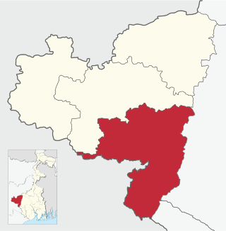
Manbazar subdivision is a subdivision of the Purulia district in the state of West Bengal, India.

Laulara is a village in the Puncha CD block in the Manbazar subdivision of the Purulia district in the state of West Bengal, India.

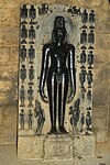
Susunia is a village in the Manbazar II CD block in the Manbazar subdivision of the Purulia district in the state of West Bengal, India.

Kuruktopa is a village in the Puncha CD block in the Manbazar subdivision of the Purulia district in the state of West Bengal, India.

Chharra is a village in the Purulia II CD block in the Purulia Sadar subdivision of the Purulia district in the state of West Bengal, India.

Budhpur is a village in the Manbazar I CD block in the Manbazar subdivision of the Purulia district in the state of West Bengal, India.

Ambikanagar is a village and a gram panchayat in the Ranibandh CD block in the Khatra subdivision of the Bankura district in the state of West Bengal, India.

Deulbhira is a village in the Taldangra CD block in the Khatra subdivision of the Bankura district in the state of West Bengal, India.

References

  1. Houlton, Sir John, Bihar, the Heart of India, 1949, p. 170, Orient Longmans Ltd.
  2. "District Statistical Handbook 2014 Purulia". Tables 2.1, 2.2. Department of Planning and Statistics, Government of West Bengal. Archived from the original on 21 January 2019. Retrieved 12 January 2020.
  3. "CD block Wise Primary Census Abstract Data(PCA)". 2011 census: West Bengal – District-wise CD blocks. Registrar General and Census Commissioner, India. Retrieved 16 January 2020.
  4. "Travel and Tourism : Purulia". The Official Website of Purulia District.
  5. "Bengal District Gazetteers – Manbhum by H. Coupland". Page 76: Manbhum, Castes and Tribes. University of California, San Diego. Retrieved 10 February 2020.
  6. "C.D. Block Wise Primary Census Abstract Data(PCA)". West Bengal – District-wise CD Blocks. Registrar General and Census Commissioner, India. Retrieved 19 January 2020.
  7. "District Census Handbook, Puruliya, Series 20, Part XII A" (PDF). Page 102:Brief Description of Places of Religious, Historical or Archaeological Importance and Places of Tourist Interest of the District. Directorate of Census Operations, West Bengal. Retrieved 19 January 2020.
  8. Google maps
  9. Bradshaw, George (1860), Bradshaw's hand-book to the Bengal presidency, and Western provinces of India, Oxford University, p. 221
  10. "Travel and Tourism : Purulia". The Official Website of Purulia District.