Baranti

Last updated

Baranti
Village
Baranti village in Purilia 08.jpg
Baranti Lake
West Bengal location map.svg
Red pog.svg
Baranti
Location in West Bengal, India
India location map.svg
Red pog.svg
Baranti
Baranti (India)
Coordinates: 23°34′52″N86°50′47″E / 23.5811°N 86.8463°E / 23.5811; 86.8463
CountryFlag of India.svg  India
State West Bengal
District Purulia
Subdivision Raghunathpur subdivision
Languages
  Official Bengali, English
Time zone UTC+5:30 (IST)
Police StationSanturi

Baranti is a small tribal village in the Santuri (community development block) in the Raghunathpur subdivision of the Purulia district in the Indian state of West Bengal. It is situated beside Baranti Lake. This is a growing but quiet tourist spot. [1]

Contents

Geography

Baranti
Invisible Square.svg
Mapscaleline.svg
8km
5miles
Red pog.svg
J
H
A
R
K
H
A
N
D
Damodar River
Panchet Dam
Reservoir
Panchet
Hill
Joychandi Pahar
R
Invisible Square.svg
Bero
R
Invisible Square.svg
Santuri
R
Invisible Square.svg
Ramchandrapur
R
Invisible Square.svg
Muraddi
R
Invisible Square.svg
Madhukunda
R
Invisible Square.svg
Kashipur
H
Invisible Square.svg
Kalloli
R
Invisible Square.svg
Baranti
T
Raghunathpur
M
Invisible Square.svg
Lapara
CT
Invisible Square.svg
Adra
CT
Invisible Square.svg
Kantaranguri
CT
Invisible Square.svg
Arra
CT
Invisible Square.svg
Murulia
CT
Invisible Square.svg
Ramkanali
R
Invisible Square.svg
Telkupi
HV
Invisible Square.svg
Garh Panchkot
H
Invisible Square.svg
Banda Deul
H
Invisible Square.svg
Usir
R
Invisible Square.svg
Sarbari
R
Invisible Square.svg
Para
H
Invisible Square.svg
Nituria
R
Invisible Square.svg
Harmadih
R
Invisible Square.svg
Haraktor
H
Invisible Square.svg
Gobag
R
Invisible Square.svg
Cheliyama
R
Invisible Square.svg
Anara
R
Invisible Square.svg
Achkoda
H
Invisible Square.svg
Parbelia
CT
Invisible Square.svg
Hijuli
CT
Invisible Square.svg
Saltore
CT
Invisible Square.svg
Nabagram
CT
Invisible Square.svg
Shankara
CT
Invisible Square.svg
Chapari
CT
Invisible Square.svg
Dubra
CT
Invisible Square.svg
Kanki
CT
Invisible Square.svg
Places in Raghunathpur subdivision in Purulia district
M: municipal town, CT: census town, R: rural/ urban centre, H: historical/ religious centre, T: tourist centre
Owing to space constraints in the small map, the actual locations in a larger map may vary slightly

Location

Baranti is located at 23°34′52″N86°50′47″E / 23.5811°N 86.8463°E / 23.5811; 86.8463 .

Area overview

Purulia district forms the lowest step of the Chota Nagpur Plateau. The general scenario is undulating land with scattered hills. [2] Panchet Hill rises to a height of 1,600 feet (490 m). [3] The Damodar forms the northern boundary of the district, but the Panchet Dam across the river is in Dhanbad district of Jharkhand. [4] Raghunathpur subdivision occupies the northern part of the district. 83.80% of the population of the subdivision lives in rural areas. However, there are pockets of urbanization and 16.20% of the population lives in urban areas. There are 14 census towns in the subdivision. [5] It is presented in the map given alongside. There is a coal mining area around Parbelia [6] and two thermal power plants are there – the 500 MW Santaldih Thermal Power Station [7] and the 1200 MW Raghunathpur Thermal Power Station. The subdivision has a rich heritage of old temples, some of them belonging to the 11th century or earlier. The Banda Deul is a monument of national importance. [8] [9] The comparatively more recent in historical terms, Panchkot Raj has interesting and intriguing remains in the area. [10] [11]

Note: The map alongside presents some of the notable locations in the subdivision. All places marked in the map are linked in the larger full screen map.

Transport

The nearest railway connection of Baranti is Muradi railway station (6 km) on the Asansol-Adra line of South Eastern Railway zone. Bus and cars are available through the district headquarters Purulia to nearby Muraddi. [12]

Tourism

Sunset at Baranti Lake Sunset, Boronti.jpg
Sunset at Baranti Lake
Baranti Lake Boronti Lake.jpg
Baranti Lake

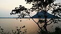
Baranti is a developing tourist center located in the lap of Gorongi Hill. This village is surrounded by the Panchkot Hill at one side and the Biharinath Hill on the other, with a water reservoir under Ramchandrapur Medium Irrigation Project. This area is popular for hill and jungle trekking due to its natural environment. [13] Garh Panchkot is only 12 km away, and Joychandi Pahar just 21 km away from Baranti. [14] Biharinath, the Araku Valley of Bengal is just 18 km from Baranti.

The place has been aptly described in The Telegraph , "right in the lap of a hilly range with a huge water reservoir...Sunset is particularly special in Baranti. The lake keeps changing colour from time to time. It’s a real treat for the eyes to sit and watch the various shades of yellow and red reflected on the water and quietly spreading out on to the paddy fields... The huge water body around the dam attracts a lot of migratory birds every winter." [13]

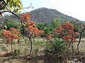
In recent years, a large number of resorts have come up in Baranti turning the place into a tourist hub. The tourist inflow is high during the winter months when the temperature is favourable. During the spring the blooming Palash flowers turn the area into a bright shade of red. [15]

Related Research Articles

Madhukunda is a census village under Bailtora village panchayat of Santuri intermediate panchayat in Purulia district in the Indian state of West Bengal. It is located on the south bank of Damodar River. It is served by the post office at Sunuri.

Gobag is a village in the Neturia CD block in the Raghunathpur subdivision of the Purulia district in the state of West Bengal, India.

Nabagram is a census town in the Raghunathpur II CD block in the Raghunathpur subdivision of the Purulia district in West Bengal, India.

Para is a village, with a police station, in the Para CD block in the Raghunathpur subdivision of the Purulia district in West Bengal, India.

<span class="mw-page-title-main">Kashipur, West Bengal</span> Village in West Bengal, India

Kashipur is a village, with a police station, in the Kashipur CD block in the Raghunathpur subdivision of the Purulia district in West Bengal, India. Kalloli, where the CD Block headquarters are located, is close to Kashipur.

<span class="mw-page-title-main">Joychandi Pahar</span> Hill in Purulia, West Bengal, India

Joychandi Pahar is a hill which is a popular tourist attraction in the Indian state of West Bengal in Purulia district. It is two kilometres from the subdivisional town of Raghunathpur and four kilometres from Adra town. The hill is situated 2 kilometers south from Purulia – Barakar road via Nanduara village and 1 kilometer west from Raghunathpur-Adra Road via a growing township known as Annapurna pally. It is also just four kilometres away from Adra Junction railway station and 1.5 kilometres from Joychandipahar railway station, which is situated on Adra-Asansol section. Joychandi hill is a popular tourist centre and major attraction for rock climbing. Joychandi Pahar railway station is on the Asansol – Adra section of South Eastern Railway, in the state capital of Kolkata. The other rock climbing centre nearby is at Susunia Pahar.

Anara is a Town in the Para CD block in the Raghunathpur subdivision of the Purulia district, West Bengal, India, about 14 km from Adra Junction. Anara Railway Station is having 2 platforms for up trains and down trains. Anara has large number of Railway employees mostly Running staff residing in 3 pockets viz. Bungalow side, Old colony and new colony apart from the market area. There is a big railway school and adjacent to it a play ground.

Santuri is a village, with a police station, in the Santuri CD block in the Raghunathpur subdivision of the Purulia district in West Bengal, India.

Nituria is a village, with a police station, in the Neturia CD block in the Raghunathpur subdivision of the Purulia district in West Bengal, India.

Kalloli is a village in the Kashipur CD block in the Raghunathpur subdivision of the Purulia district in the state of West Bengal, India. It is close to Kashipur.

<span class="mw-page-title-main">Cheliyama</span> Village in West Bengal, India

Cheliyama is a village in the Raghunathpur II CD block in the Raghunathpur subdivision of the Purulia district in the state of West Bengal, India.

Muraddi is a village in the Santuri CD block in the Raghunathpur subdivision of the Purulia district in the state of West Bengal, India. Muradi Dam is a tourist spot.

Ramchandrapur is a village in Santuri CD Block in Raghunathpur subdivision of Purulia district in the state of West Bengal, India.

Achkoda is a village in the Neturia CD block in the Raghunathpur subdivision of the Purulia district in the state of West Bengal, India.

Haraktor is a village in the Para CD block in the Raghunathpur subdivision of the Purulia district in the state of West Bengal, India.

Usir is a village in the Raghunathpur II CD block in the Raghunathpur subdivision of the Purulia district in the state of West Bengal, India.

Sarbari is a village in West Bengal, India. It is located within Neturia CD block of Raghunathpur subdivision of Purulia district.

Harmadih is a village in the Neturia CD block in the Raghunathpur subdivision of the Purulia district in the state of West Bengal, India.

Murulia is a census town in the Santuri CD block in the Raghunathpur subdivision of the Purulia district in the state of West Bengal, India.

Kantaranguri is a census town in the Kashipur CD block in the Raghunathpur subdivision of the Purulia district in the state of West Bengal, India.

References

  1. "Tourist spots in Purulia being developed by the Bengal Govt". news.webindia123.com. 24 May 2017. Archived from the original on 27 August 2017. Retrieved 27 August 2017.
  2. Houlton, Sir John, Bihar, the Heart of India, 1949, p. 170, Orient Longmans Ltd.
  3. "Bengal District Gazetteers - Manbhum by H. Coupland, ICS". First Published 1911. University of California, San Diego. Retrieved 27 September 2016.
  4. Mahesh Chand; V.K. Puri (1983). Regional Planning in India. Allied Publishers. p. 423. ISBN   978-81-7023-058-8.
  5. "District Statistical Handbook 2014 Purulia". Tables 2.1, 2.2. Department of Planning and Statistics, Government of West Bengal. Archived from the original on 21 January 2019. Retrieved 12 January 2020.
  6. "Area wise Closed User Group (CUG) Telephone Numbers" (PDF). Sodepur Area. Eastern Coalfields Limited. Retrieved 11 August 2018.
  7. "Santaldih Thermal Power Station - WBPDCL". WBPDCL. Archived from the original on 11 January 2010. Retrieved 24 August 2011.
  8. "Old temple at Banda (locally known as deul)". ASI, Kolkata Circle. Retrieved 23 January 2020.
  9. "List of Ancient Monuments and Archaeological Sites and Remains of West Bengal - Archaeological Survey of India". Item no. 134. ASI. Retrieved 25 January 2020.
  10. "Capital in shambles: Garh Panchakot, Purulia". Heritage in Peril. Archived from the original on 1 December 2016. Retrieved 1 December 2016.
  11. "Historical ruins". Trek Earth. Retrieved 1 December 2016.
  12. "PURULIA". wbtourismgov.in. Retrieved 27 August 2017.
  13. 1 2 "Next weekend you can be at ... Baranti". telegraphindia.com. 27 December 2009. Archived from the original on 26 February 2010. Retrieved 27 August 2017.
  14. "নীলাভ সুন্দরী হয়ে প্রতীক্ষায় বড়ন্তি". anandabazar.com. 25 May 2017. Retrieved 27 August 2017.
  15. Datta, Rangan (26 December 2024). "Baranti in Purulia: An untapped weekend getaway for travellers who love nature". The Teleghraph. My Kolkata. Retrieved 13 April 2024.