Purulia Sadar subdivision

Last updated
Purulia Sadar subdivision
Subdivision
Purulia Sadar (subdivision) in Purulia (West Bengal).svg
Coordinates: 23°11′N86°13′E / 23.19°N 86.22°E / 23.19; 86.22
CountryFlag of India.svg  India
State West Bengal
District Purulia
Headquarters Purulia
Area
  Total1,474.81 km2 (569.43 sq mi)
Population
 (2011)
  Total878,373
  Density600/km2 (1,500/sq mi)
Languages
  Official Bengali, English
Time zone UTC+5:30 (IST)
ISO 3166 code IN-WB
Vehicle registration WB
Website http://purulia.gov.in/

Purulia Sadar subdivision is a subdivision of the Purulia district in the state of West Bengal, India.

Contents

History

Purulia district was divided into four subdivisions, viz., Purulia Sadar, Manbazar, Jhalda and Raghunathpur, with effect from 6 April 2017, as per Order No. 100-AR/P/2R-2/1999 dated 30 March 2017 issued by the Government of West Bengal, in the Kolkata Gazette dated 30 March 2017. [1]

Subdivisions

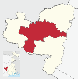
Purulia district is divided into the following administrative subdivisions: [2] [3] [4]

Purulia Subdivision Map (en).svg
SubdivisionHeadquarter
Area
km2
Population
(2011)
Rural Population %
(2011)
Urban Population %
(2011)
Purulia Sadar Purulia 1,474.81878,37381.4218.58
Manbazar Manbazar 1,766.55640,58896.323.68
Jhalda Jhalda 1,233.97573,77191.028.98
Raghunathpur Raghunathpur 1,733.01838,12883.8016.20
Purulia district Purulia 6208.342,930,86087.2412.76

Note: The 2011 census data has been recast as per reorganisation of the subdivisions. There may be minor variations.

Purulia Sadar subdivision
Places in Purulia Sadar subdivision in Purulia district
M: municipality, CT: census town, R: rural/ urban centre, H: historical/ religious centre, F: facility
Owing to space constraints in the small map, the actual locations in a larger map may vary slightly

Police stations

Police stations in the Purulia Sadar subdivision have the following features and jurisdiction: [2] [3] [5]

Police StationArea covered
km2
Inter-state border
km
Municipal TownCD block
Arsha 187.5-- Arsha
Hura 382.21-- Hura
Purulia (Town) 13.9- Purulia Purulia I, Purulia II
Purulia (Muffasil) 534.47-- Purulia I, Purulia II
Purulia Sadar Women -- Purulia, Jhalda Purulia (Muffasil), Kotshila, Arsha,
Jhalda, Jaypur police stations area
Balarampur 299.512.39- Balarampur

Blocks

Community development blocks in Purulia Sadar subdivision are: [2] [3] [4]

Purulia Tehsil Map (en).svg
CD blockHeadquartersArea
km2
Population
(2011)
SC  % ST  %Literacy
Rate %
Census
Towns
Arsha Sirkabad 375.04154,73611.8221.6954.78
Balarampur Baghadih 300.88137.95011.9131.7160.401
Hura Hura 382.21143,57519.5625.4668.79
Purulia I Chakda, PO Kotlui281.50151,18817.158.3778.371
Purulia II Bongabari,
PO Vivekanandanagar
310.10169,48827.164.8563.392

Gram panchayats

Gram panchayats in Purulia Sadar subdivision are : [2] [6]

Education

Given in the table below is a comprehensive picture of the education scenario in Purulia district, after reorganisation of the district in 2017, with data for the year 2013-14. (There may be minor variations because of data recasting).: [2] [3]

SubdivisionPrimary
School
Middle
School
High
School
Higher Secondary
School
General
College, Univ
Technical /
Professional Instt
Non-formal
Education
InstitutionStudentInstitutionStudentInstitutionStudentInstitutionStudentInstitutionStudentInstitutionStudentInstitutionStudent
Purulia Sadar81887,4251147,2922611,3458380,138612,463111,8061,46149,234
Manbazar 83259,1051214,141217,6156463,46655,44132561,37141,267
Jhalda 53353,629673,45321,4154755,49262,33229883634,779
Raghunathpur 81872,0731268,9253116,0556768,18847,00756491,76145,472
Purulia district 3,001272,23242823,8118036,430261267,2842127,243213.0095,429170,752

Note: Primary schools include junior basic schools; middle schools, high schools and higher secondary schools include madrasahs; technical schools include junior technical schools, junior government polytechnics, industrial technical institutes, industrial training centres, nursing training institutes etc.; technical and professional colleges include engineering colleges, medical colleges, para-medical institutes, management colleges, teachers training and nursing training colleges, law colleges, art colleges, music colleges etc. Special and non-formal education centres include sishu siksha kendras, madhyamik siksha kendras, centres of Rabindra mukta vidyalaya, recognised Sanskrit tols, institutions for the blind and other handicapped persons, Anganwadi centres, reformatory schools etc. [3]

Educational institutions

The following institutions are located in Purulia Sadar subdivision:

Healthcare

The table below (all data in numbers) presents an overview of the medical facilities available and patients treated in the hospitals, health centres and sub-centres in 2014 in Purulia district, after reorganisation of the district in 2017, with data for the year 2013-14. (There may be minor variations because of data recasting).: [2] [3]

SubdivisionHealth & Family Welfare Deptt, WB Other
State
Govt
Deptts
Local
bodies
Central
Govt
Deptts /
PSUs
NGO /
Private
Nursing
Homes
TotalTotal
Number
of
Beds
Total
Number
of
Doctors*
Indoor
Patients
Outdoor
Patients
Hospitals
Rural
Hospitals
Block
Primary
Health
Centres
Primary
Health
Centres
Purulia Sadar223132--9311,20396209,3901,626,712
Manbazar -1414----192544035,184990,561
Jhalda -1310----151962328,522820,961
Raghunathpur 11413--12228357755,8661,071,786
Purulia district 3514502-112872,488236328,9624,510,020

.* Excluding nursing homes.

Medical facilities

Medical facilities in Purulia Sadar subdivision are as follows:

Hospitals: (Name, location, beds) [14]

Rural Hospitals: (Name, CD block, location, beds) [15]

Primary Health Centres : (CD block-wise)(CD block, PHC location, beds) [16]

Electoral constituencies

Lok Sabha (parliamentary) and Vidhan Sabha (state assembly) constituencies in Purulia district were as follows:

Lok Sabha constituencyVidhan Sabha constituencyReservationCD Block and/or Gram panchayat
Purulia Balarampur None Balarampur CD Block; Chakaltore, Dimdiha, Durku, Garafusra, Lagda
and Sonaijuri gram panchayats of Purulia I CD Block; and Chatu Hansa,
Hensla and Puara gram panchayats of Arsha CD Block. [17]
Baghmundi None Jhalda municipality; Jhalda I and Baghmundi CD Blocks;
Hetgugui and Sirkabad gram panchayats of Arsha CD Block. [17]
Joypur None Joypur and Jhalda II CD Blocks;
Arsha, Beldih and Manikary gram panchayats of Arsha CD Block. [17]
Purulia None Purulia municipality; Purulia II CD Block; Bhandar Purachipida
and Manara gram panchayats of Purulia I CD Block. [17]
Manbazar ST Manbazar I and Puncha CD Blocks; Chatumadar, Daldali
and Manguria Lalpur gram panchayats of Hura CD Block. [17]
Kashipur None Kashipur CD Block; Hura, Jabarrah, Kalabani, Keshargarh, Ladhurka,
Lakhanpur and Rakhera Bishpuri gram panchayats of Hura CD Block. [17]
Para SC Para and Raghunathpur II CD Blocks. [17]
Bankura Raghunathpur SC Raghunathpur municipality; Raghunathpur I, Neturia and Santuri CD Blocks. [17]
Other assembly segments in Bankura district
Jhargram (ST) Bandwan ST Bandwan, Barabazar and Manbazar II CD Blocks. [17]
Other assembly segments in Paschim Medinipur district

Related Research Articles

<span class="mw-page-title-main">Purulia</span> City in West Bengal, India

Purulia, officially Purulia Sadar, is a city and a municipality in the Indian state of West Bengal. It is the headquarters of the Purulia district. It is located on the north of the Kangsabati River.

<span class="mw-page-title-main">Darjeeling Sadar subdivision</span> Subdivision in West Bengal, India

Darjeeling Sadar subdivision is a subdivision of the Darjeeling district in the state of West Bengal, India.

Balarampur is a census town in the Balarampur CD block in Purulia Sadar subdivision of the Purulia district in the state of West Bengal, India. Before Indian independence in 1947, it was the capital of an expensive zamindari of Barabhum in British India.

<span class="mw-page-title-main">Arsha (community development block)</span> Community development block in West Bengal, India

Arsha is a community development block that forms an administrative division in the Purulia Sadar subdivision of the Purulia district in the Indian state of West Bengal.

<span class="mw-page-title-main">Hura (community development block)</span> Community development block in West Bengal, India

Hura is a community development block that forms an administrative division in the Purulia Sadar subdivision of the Purulia district in the Indian state of West Bengal.

<span class="mw-page-title-main">Bankura Sadar subdivision</span> Subdivision in West Bengal, India

Bankura Sadar subdivision is a subdivision of the Bankura district in the state of West Bengal, India.

<span class="mw-page-title-main">Cooch Behar Sadar subdivision</span> Subdivision in West Bengal, India

Cooch Behar Sadar subdivision is a subdivision of the Cooch Behar district in the state of West Bengal, India.

<span class="mw-page-title-main">Tufanganj subdivision</span> Subdivision in West Bengal, India

Tufanganj subdivision is a subdivision of the Cooch Behar district in the state of West Bengal, India.

<span class="mw-page-title-main">Alipore Sadar subdivision</span> Subdivision in West Bengal, India

Alipore Sadar subdivision is an administrative subdivision of the South 24 Parganas district in the Indian state of West Bengal.

Purulia Sadar West subdivision was a subdivision of the Purulia district in the state of West Bengal, India, till reorganisation of the subdivisions in Purlia district in 2017.

<span class="mw-page-title-main">Raghunathpur subdivision</span> Subdivision in West Bengal, India

Raghunathpur subdivision is a subdivision of the Purulia district in the state of West Bengal, India.

<span class="mw-page-title-main">Purulia I</span> Community development block in West Bengal, India

Purulia I is a community development block that forms an administrative division in the Purulia Sadar subdivision of the Purulia district in the Indian state of West Bengal.

Hura is a village, with a police station, in the Hura CD block in the Purulia Sadar subdivision of the Purulia district in the state of West Bengal, India.

<span class="mw-page-title-main">Balarampur, Purulia (community development block)</span> Community development block in West Bengal, India

Balarampur is a community development block that forms an administrative division in the Purulia Sadar subdivision of the Purulia district in the Indian state of West Bengal.

Arsha is a village, with a police station, in the Arsha CD block in the Purulia Sadar subdivision of the Purulia district in the state of West Bengal, India.

Sirkabad is a village in the Arsha CD block in the Purulia Sadar subdivision of the Purulia district in the state of West Bengal, India.

<span class="mw-page-title-main">Jhalda subdivision</span> Subdivision in West Bengal, India

Jhalda subdivision is a subdivision of the Purulia district in the state of West Bengal, India.

<span class="mw-page-title-main">Manbazar subdivision</span> Subdivision in West Bengal, India

Manbazar subdivision is a subdivision of the Purulia district in the state of West Bengal, India.

Chakaltor is a village and a gram panchayat in the Purulia I CD block in the Purulia Sadar subdivision of the Purulia district in the state of West Bengal, India.

Lagda is a census town and a gram panchayat in the Purulia I CD block in the Purulia Sadar subdivision of the Purulia district in the state of West Bengal, India.

References

  1. "The Kolkata Gazette, 30 March 2017" (PDF). Government of West Bengal. Retrieved 17 January 2020.
  2. 1 2 3 4 5 6 "Purulia – the official website of Purlia district". Administration. District administration. Retrieved 16 January 2020.
  3. 1 2 3 4 5 6 "District Statistical Handbook 2014 Purulia". Tables 2.1, 2.2. Department of Planning and Statistics, Government of West Bengal. Archived from the original on 21 January 2019. Retrieved 16 January 2020.
  4. 1 2 "CD block Wise Primary Census Abstract Data(PCA)". 2011 census: West Bengal – District-wise CD blocks. Registrar General and Census Commissioner, India. Retrieved 16 January 2020.
  5. "Purulia District Police". PDC. Retrieved 16 January 2020.
  6. "Directory of District, Subdivision, Panchayat Samiti/ Block and Gram Panchayats in West Bengal". Purulia - Revised in March 2008. Panchayats and Rural Development Department, Government of West Bengal. Retrieved 16 January 2020.
  7. "Sidho-Kano-Birsha University". SKBU. Retrieved 17 January 2020.
  8. "Purulia Government Medical College & Hospital". PGMCH. Retrieved 17 January 2020.
  9. "Jagannath Kishore College". JKC. Retrieved 17 January 2020.
  10. "Nistarini Women's College". NWC. Retrieved 17 January 2020.
  11. "Arsha College". College Admission. Retrieved 17 January 2020.
  12. "Balarampur College". BC. Retrieved 17 January 2020.
  13. "Mahatma Gandhi College". MGC. Retrieved 17 January 2020.
  14. "Health & Family Welfare Department" (PDF). Health Statistics - Hospitals. Government of West Bengal. Retrieved 18 January 2020.
  15. "Health & Family Welfare Department" (PDF). Health Statistics – Rural Hospitals. Government of West Bengal. Retrieved 18 January 2020.
  16. "Health & Family Welfare Department" (PDF). Health Statistics – Primary Health Centres. Government of West Bengal. Retrieved 18 January 2020.
  17. 1 2 3 4 5 6 7 8 9 "Delimitation Commission Order No. 18 dated 15 February 2006" (PDF). West Bengal. Election Commission of India. Retrieved 10 October 2016.