Charida | |
|---|---|
Village | |
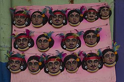 Masks at Charida | |
 Charida Location in West Bengal, India  Charida Charida (India) | |
| Coordinates: 23°12′17″N86°01′53″E / 23.2046°N 86.0314°E | |
| Country | |
| State | West Bengal |
| District | Purulia |
| Population (2011) | |
• Total | 2,568 |
| Languages | |
| • Official | Bengali, English |
| Time zone | UTC+5:30 (IST) |
| PIN | 723152 |
| Telephone/STD code | 03254 |
| Lok Sabha constituency | Purulia |
| Vidhan Sabha constituency | Baghmundi |
| Website | purulia |
 8km 5miles J H A R K H A N D △ Chandni Hill △ V Ajodhya Hills △ Chamtuburu T Subarnarekha River T T Bamni Falls T T Ajodhya Hill top X Charida H R R Patardi R R R R R R R M C C C Places in Jhalda subdivision in Purulia district. Key: M: municipality, C: census town, R: rural/ urban centre, H: historical/ religious centre, X: craft centre, T: tourist centre, △: hills Owing to space constraints in the small map, the locations in the larger map on click through may vary slightly. | |
Charida (also referred to as Chorida, Chorda) is a village in the Baghmundi CD block in the Jhalda subdivision of the Purulia district in the state of West Bengal, India.


