Places in Jhalda subdivision in Purulia district. Key: M: municipality, C: census town, R: rural/ urban centre, H: historical/ religious centre, X: craft centre, T: tourist centre, △: hills Owing to space constraints in the small map, the locations in the larger map on click through may vary slightly.
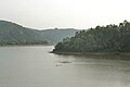
The Murguma Dam[1] is constructed on the Saharajhore River,[2] a tributary of the Kangsabati River in West Bengal, India. The dam is constructed near Murguma,[3] a village in the foothills of the Ajodhya Hills, Purulia District. The dam is situated at the north west end of Ajodhya Hills which is considered as an eastern extension of Chota Nagpur Plateau, resulting in the dam being surrounded by hills and forests. A number of other streams also flow into the dam directly from the Ajodhya Hills and the dam's lake contains a number of small islands.[4][bettersourceneeded]
The area is mainly inhabited by tribal people,[5][1] with the Santal people predominant.[6] The local economy is mainly dependent on agriculture.[7] However, there is potential for tourism which might improve economic conditions for the local population so the government is promoting it as a tourist destination.[3] This dam is one of the key small irrigation projects[8] in rural, arid areas of West Bengal.[2][6][5] While one of the promising tourist spots of Eastern Chota Nagpur Plateau region, to date, no facility of boating offered. The dam and surroundings are attractive locations for backpackers.[9] The dam features in the tourism brochure of Government Tourist Department of Purulia District.[10]
Accessibility
The nearest railway station is Jhalda, from where it is accessible by single metalled road. The other option is to follow the Purulia-Tamna more-Arsha-Begunkodor-Murguma route for 50km (31mi). As the accessibility is not good this is perhaps one of the reasons that the locality still offers wild beauty.
Being far from urban disturbance, this dam is a location for research on indigenous aquatic flora,[11][12] and fauna.[13] This area was affected by a Maoist insurgency in the past,[14] and is under the jurisdiction of Kotshila Police Station.[citation needed]
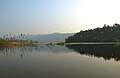
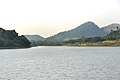
Gallery
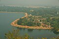
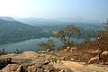
View from Ajodhya Hill
View of Murguma Dam and Murguma Village from Ajyodhya Hill View Point
View of Murguma Dam and Murguma Village from Ajyodhya Hill View Point
This page is based on this Wikipedia article Text is available under the CC BY-SA 4.0 license; additional terms may apply. Images, videos and audio are available under their respective licenses.