Phulia

Last updated

Phulia
Fulia
Census Town
Weaving Tant Saree by Handloom - 2 Natun Phulia - Nadia 2016-11-12 1808.JPG
Weaving a tant sari at Phulia
West Bengal location map.svg
Red pog.svg
Phulia
Location in West Bengal, India
India location map 3.png
Red pog.svg
Phulia
Phulia (India)
Coordinates: 23°14′04″N88°30′22″E / 23.2344°N 88.5062°E / 23.2344; 88.5062
CountryFlag of India.svg  India
State West Bengal
District Nadia
Area
  Total15.02 km2 (5.80 sq mi)
Population
 (2011)
  Total55,653
  Density3,700/km2 (9,600/sq mi)
Languages
  Official Bengali, English
Time zone UTC+5:30 (IST)
PIN
741402
ISO 3166 code IN-WB
Vehicle registration WB
Lok Sabha constituency Ranaghat
Vidhan Sabha constituency Ranaghat Uttar Paschim
Website wb.gov.in

Phulia (also spelled Fulia) is a census town in the Santipur CD block of the Ranaghat subdivision in the Nadia district in the Indian state of West Bengal. [1] It is birthplace of 'Adi kavi' of Bengal Krittibas Ojha.

Contents

Geography

Phulia
Cities and towns in Ranaghat subdivision of Nadia district
M: municipal town/ city/notified area, CT: census town, R: rural/ urban centre.
Owing to space constraints in the small map, the actual locations in a larger map may vary slightly

Location

Fulia is located at 23°14′04″N88°30′22″E / 23.2344°N 88.5062°E / 23.2344; 88.5062 .

Area overview

Nadia district is mostly alluvial plains lying to the east of Hooghly River, locally known as Bhagirathi. The alluvial plains are cut across by such distributaries as Jalangi, Churni and Ichhamati. With these rivers getting silted up, floods are a recurring feature. [2] The Ranaghat subdivision has the Bhagirathi on the west, with Purba Bardhaman and Hooghly districts lying across the river. Topographically, Ranaghat subdivision is spread across the Krishnanagar-Santipur Plain, which occupies the central part of the district, and the Ranaghat-Chakdaha Plain, the low-lying area found in the south-eastern part of the district. The Churni separates the two plains. A portion of the east forms the boundary with Bangladesh. The lower portion of the east is covered by a portion of the North 24 Parganas district. [3] The subdivision has achieved reasonably high urbanisation. 41.68% of the population lives in urban areas and 58.32% lives in rural areas. [4]

Note: The map alongside presents some of the notable locations in the subdivision. All places marked in the map are linked in the larger full screen map. All the four subdivisions are presented with maps on the same scale – the size of the maps vary as per the area of the subdivision.

Civic administration

CD block HQ

The headquarters of Santipur CD block are located at Buincha, as per Nadia District Census Handbook 2011. On page 422 in the Santipur CD Block map, Buincha is shown as part of Phulia census town. [5] According to the district administration, the Block Development Office is located at PO Fulia Colony. [6]

Krittibas Memorial Krittibas Memorial ver1.jpg
Krittibas Memorial

Infrastructure

According to the District Census Handbook 2011, Nadia, Phulia covered an area of 15.02 km2. Among the civic amenities, the protected water supply involved tap water from untreated sources, tube well, borewell. It had 3,200 domestic electric connections, 360 road light points. Among the medical facilities, the nearest dispensary/ health centre was 2 km away. Among the educational facilities it had 18 primary schools, 3 secondary schools, 3 senior secondary schools. It had 1 polytechnic, 2 recognised short-hand, type writing and vocational training institutes and 13 non-formal education centres (Sarva Shikhsha Abhiyan). Among the social, recreational and cultural facilities, it had 1 cinema theatre, 2 auditorium/ community halls, 2 public libraries, 2 reading rooms. Three important items it produced were handloom sari, ghee, poultry products. It had branch offices of 1 nationalised bank, 1 private commercial bank, 1 agricultural credit society, 7 non-agricultural credit societies. [7]

Economy

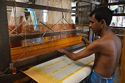
After partition of India, many skilled weavers of Dhaka came and settled in West Bengal around Shantipur in Nadia district and Ambika Kalna of Bardhaman district, both traditionally renowned centres for hand-woven fabrics. With government encouragement and support, the talented weavers soon revived their ancestral occupation and the art of exquisite weaving once again flourished. Today, finely woven feather-touch textiles and saris in exotic designs and colours are being produced in the vast weaving belt of Shantipur, Phulia, Samudragarh, Dhatrigram and Ambika Kalna—each centre producing superb fabrics in its own unique weaving style. Dhatrigram produces jacquards and jamdanis while Kalna is famous for tangails and gorgeous jamdanis. Phulia and Samudragarh specialize in a combination of jacquard and jamdani work which are based on Tangail Saree Culture of Bangladesh while Santipur is known for superfine dhotis and jacquards. The produce is marketed through some whole sellers & co-operatives and various undertakings. But nowadays, the main problem in making the handicraft is the rising price of raw materials and inadequate supply of skilled labour (mainly from Cooch Behar district of West Bengal and Assam region). So, the economy based on Tant Saree is a diminishing economy and the next generation is not so much interested in this crafts. The weavers need some economic and administrative supports from the Government. [8]

Transport

Phulia railway station is a railway station of the Kolkata Suburban Railway system and operated by Eastern Railway. It is situated beside National Highway 34 at Chatkatala, Phulia on the Ranaghat–Shantipur line in Nadia district in the Indian state of West Bengal.The distance between Sealdah to Phulia railway station is approximately 89 km.

Demographics

According to the 2011 Census of India, Phulia had a total population of 55,653, of which 28,695 (52%) were males and 26,958 (48%) were females. Population in the age range 0–6 years was 4,676. The total number of literate persons in Phulia was 41,752 (81.90% of the population over 6 years). [9]

The following municipality, notified area, outgrowths and census towns were part of Shantipur Urban Agglomeration in 2011 census: Shantipur (M), Taherpur (NA), Taherpur (OG), Barasat (OG), Bhaduri (OG), Mahisdanga (OG), Phulia (CT), Patuli (CT), Badkulla (CT), Ghoralia (CT), Beharia and Gangni. [10]

As of 2001 India census, [11] Phulia had a population of 50,254. Males constitute 52% of the population and females 48%. Phulia has an average literacy rate of 68%, higher than the national average of 59.5%: male literacy is 74%, and female literacy is 62%. In Phulia, 11% of the population is under 6 years of age.

Education

There are many schools and institutes in this region, some of the schools are listed below.

Training institutes are listed below.

Personalities

Kabi Krittibas Ojha (15th century poet), who wrote Ramayan in Bengali used to live here.

Healthcare

Nabla (Fulia) Block Primary Health Centre, with 10 beds at Fulia Colony, is the major government medical facility in the Santipur CD block. [12] [13]

Related Research Articles

<span class="mw-page-title-main">Shantipur</span> City in West Bengal, India

Santipur is a city and a municipality in the Ranaghat subdivision of Nadia district in the Indian state of West Bengal. The fort area of this city, also known as Daak-Garh is thought to have been built by Raja Krishnachandra of Nadia.

Jagadanandapur is a census town in the Nakashipara CD block in the Krishnanagar Sadar subdivision of the Nadia district in the Indian state of West Bengal,and the town is part of Bethuadahari 1 G.P.

Parbbatipur is a census town in Ranaghat I CD Block in Ranaghat subdivision of Nadia district in the Indian state of West Bengal.

Satigachha is a census town in the Ranaghat I CD block in the Ranaghat subdivision of the Nadia district in the Indian state of West Bengal.

<span class="mw-page-title-main">Taherpur</span> Town in West Bengal, India

Taherpur is a town and a notified area in Ranaghat subdivision of Nadia district in the Indian state of West Bengal.

<span class="mw-page-title-main">Badkulla</span> Census Town in West Bengal, India

Badkulla is a census town in the Hanskhali CD block in the Ranaghat subdivision of the Nadia district in the Indian state of West Bengal.

<span class="mw-page-title-main">Ranaghat subdivision</span> Subdivision in West Bengal, India

Ranaghat Subdivision is an administrative subdivision located at Nadia district, in the state of West Bengal, India The subdivision is administered by SDM/SDO(Ranaghat).

<span class="mw-page-title-main">Santipur (community development block)</span> Community development block in West Bengal, India

Santipur is a community development block that forms an administrative division in Ranaghat subdivision of Nadia district in the Indian state of West Bengal.

<span class="mw-page-title-main">Ranaghat I</span> Community development block in West Bengal, India

Ranaghat I is a community development block that forms an administrative division in Ranaghat subdivision of Nadia district in the Indian state of West Bengal.

<span class="mw-page-title-main">Kalna I</span> Community development block in West Bengal, India

Kalna I is a community development block that forms an administrative division in Kalna subdivision of Purba Bardhaman district in the Indian state of West Bengal.

Samudragarh is a village in Purbasthali I CD block in Kalna subdivision of Purba Bardhaman district in the state of West Bengal, India. Nadanghat police station serves this village. It is about 15 km away from Kalna, India. It is situated on the western bank of the Bhāgirathi.

Nrisinghapur is a census town in the Santipur CD block in the Ranaghat subdivision of the Nadia district in the state of West Bengal, India.

Harinadibhastsala is a census town in the Santipur CD block in the Ranaghat subdivision of the Nadia district in the state of West Bengal, India.

Ghoralia is a census town in the Santipur CD block in the Ranaghat subdivision of the Nadia district in the state of West Bengal, India.

Beharia is a census town in the Santipur CD block in the Ranaghat subdivision of the Nadia district in the state of West Bengal, India.

Patuli is a census town in the Hanskhali CD block in the Ranaghat subdivision of the Nadia district in the state of West Bengal, India.

Gangni is a census town in the Ranaghat I CD block in the Ranaghat subdivision of the Nadia district in the state of West Bengal, India.

Raghabpur is a census town in the Ranaghat I CD block in the Ranaghat subdivision of the Nadia district in the state of West Bengal, India.

Anulia is a census town in the Ranaghat I CD block in the Ranaghat subdivision of the Nadia district in the state of West Bengal, India.

Ranaghat (CT) is a census town in the Ranaghat II CD block in the Ranaghat subdivision of the Nadia district in the state of West Bengal, India.

References

  1. "District Wise List of Statutory Towns". Census of India 2001, Urban Frame. Directorate of Census Operations, West Bengal. Archived from the original on 30 September 2007. Retrieved 6 October 2007.
  2. Gangopadhyay, Basudev, Paschimbanga Parichay, 2001, (in Bengali), p. 70, Sishu Sahitya Sansad
  3. "District Census Handbook, Nadia, 2011, Series 20, Part XII A" (PDF). Pages 13,14. Directorate of Census Operations, West Bengal. Retrieved 16 October 2020.
  4. "District Statistical Handbook 2014 Nadia". Table 2.2, 2.4(a). Department of Planning and Statistics, Government of West Bengal. Retrieved 16 October 2020.
  5. "District Census Handbook: Nadia, Series 20 Part XII A" (PDF). Map of Nadia with CD Block HQs and Police Stations (on the fourth page) and Map of Santipur CD Block (on page 422). Directorate of Census Operations, West Bengal, 2011. Retrieved 23 May 2017.
  6. "Ranaghat Sub-division". Slock. Rananaghat SDO. Retrieved 23 May 2017.
  7. "District Census Handbook Nadia, Census of India 2011, Series 20, Part XII A" (PDF). Section II Town Directory, Pages 635-656; Statement I: Status and Growth History, Page 635; Statement II: Physical Aspects and Location of Towns, Page 641; Statement III: Civic and other Amenities, Page 643; Statement IV: Medical Facilities, Page 646; Statement V: Educational, Recreational and Cultural Facilities, Page 655; Statement VI:Industry and Banking ,Page 2833. Directorate of census Operations V, West Bengal. Retrieved 30 September 2020.
  8. "A Traditional Panorama - Bengal Art". Arts and Crafts in India. India Profile. Retrieved 8 September 2007.
  9. "2011 Census – Primary Census Abstract Data Tables". West Bengal – District-wise. Registrar General and Census Commissioner, India. Retrieved 18 May 2017.
  10. "Provisional Population Totals, Census of India 2011" (PDF). Constituents of Urban Agglomeration Having Population Above 1 Lakh. Census of India 2011. Retrieved 18 October 2020.
  11. "Census of India 2001: Data from the 2001 Census, including cities, villages and towns (Provisional)". Census Commission of India. Archived from the original on 16 June 2004. Retrieved 1 November 2008.
  12. "Health & Family Welfare Department" (PDF). Health Statistics – Block Primary Health Centres. Government of West Bengal. Retrieved 4 October 2020.
  13. "Health & Family Welfare Department" (PDF). Health Statistics – Primary Health Centres. Government of West Bengal. Retrieved 10 October 2020.