Patuli, Nadia

Last updated

Patuli
Census Town
West Bengal location map.svg
Red pog.svg
Patuli
Location in West Bengal, India
India location map 3.png
Red pog.svg
Patuli
Patuli (India)
Coordinates: 23°18′07″N88°30′56″E / 23.3020°N 88.5155°E / 23.3020; 88.5155 Coordinates: 23°18′07″N88°30′56″E / 23.3020°N 88.5155°E / 23.3020; 88.5155
CountryFlag of India.svg  India
State West Bengal
District Nadia
Area
  Total1.5369 km2 (0.5934 sq mi)
Population
 (2011)
  Total6,441
  Density4,200/km2 (11,000/sq mi)
Languages
  Official Bengali, English
Time zone UTC+5:30 (IST)
PIN
741121
Telephone/STD code03473
Lok Sabha constituency Ranaghat
Vidhan Sabha constituency Krishnaganj
Website nadia.gov.in

Patuli is a census town in the Hanskhali CD block in the Ranaghat subdivision of the Nadia district in the state of West Bengal, India.

Contents

Geography

Cities and towns in Ranaghat subdivision of Nadia district
M: municipal town/ city/notified area, CT: census town, R: rural/ urban centre.
Owing to space constraints in the small map, the actual locations in a larger map may vary slightly

Location

Patuli is located at 23°18′07″N88°30′56″E / 23.3020°N 88.5155°E / 23.3020; 88.5155 .

The map of Hanskhali CD block, in the District Census Handbook 2011, Nadia, shows Badkulla and Patuli as adjacent census towns. [1]

Area overview

Nadia district is mostly alluvial plains lying to the east of Hooghly River, locally known as Bhagirathi. The alluvial plains are cut across by such distributaries as Jalangi, Churni and Ichhamati. With these rivers getting silted up, floods are a recurring feature. [2] The Ranaghat subdivision has the Bhagirathi on the west, with Purba Bardhaman and Hooghly districts lying across the river. Topographically, Ranaghat subdivision is spread across the Krishnanagar-Santipur Plain, which occupies the central part of the district, and the Ranaghat-Chakdaha Plain, the low-lying area found in the south-eastern part of the district. The Churni separates the two plains. A portion of the east forms the boundary with Bangladesh. The lower portion of the east is covered by a portion of the North 24 Parganas district. [3] The subdivision has achieved reasonably high urbanisation. 41.68% of the population lives in urban areas and 58.32% lives in rural areas. [4]

Note: The map alongside presents some of the notable locations in the subdivision. All places marked in the map are linked in the larger full screen map. All the four subdivisions are presented with maps on the same scale – the size of the maps vary as per the area of the subdivision.

Demographics

According to the 2011 Census of India, Patuli had a total population of 6,441, of which 3,298 (51%) were males and 3,143 (49%) were females. Population in the age range 0–6 years was 503. The total number of literate persons in Patuli was 5095 (85.80% of the population over 6 years). [5]

The following municipality, notified area, outgrowths and census towns were part of Shantipur Urban Agglomeration in 2011 census: Shantipur (M), Taherpur (NA), Taherpur (OG), Barasat (OG), Bhaduri (OG), Mahisdanga (OG), Phulia (CT), Patuli (CT), Badkulla (CT), Ghoralia (CT), Beharia and Gangni. [6]

Infrastructure

According to the District Census Handbook 2011, Nadia, Patuli covered an area of 1.5369 km2. Among the civic amenities, the protected water supply involved tap water from untreated sources, tube well, borewell. It had 626 domestic electric connections. Among the medical facilities, the nearest hospital was 9 km away. Among the educational facilities it had 1 primary school, other school facilities were 1 km away. It had 1 non-formal education centre (Sarva Shiksha Abhiyan). Three important items it produced were paddy, wheat, jute. [7]

Related Research Articles

<span class="mw-page-title-main">Shantipur</span> City in West Bengal, India

Santipur is a city and a municipality in the Ranaghat subdivision of Nadia district in the Indian state of West Bengal. The fort area of this city, also known as Daak-Garh is thought to have been built by Raja Krishnachandra of Nadia.

Gopalpur is a census town in the Ranaghat I CD block in the Ranaghat subdivision of the Nadia district in the Indian state of West Bengal.

Parbbatipur is a census town in Ranaghat I CD Block in Ranaghat subdivision of Nadia district in the Indian state of West Bengal.

<span class="mw-page-title-main">Phulia</span> Census Town in West Bengal, India

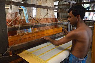
Phulia is a census town in the Santipur CD block of the Ranaghat subdivision in the Nadia district in the Indian state of West Bengal. It is birthplace of 'Adi kavi' of Bengal Krittibas Ojha.

Satigachha is a census town in the Ranaghat I CD block in the Ranaghat subdivision of the Nadia district in the Indian state of West Bengal.

<span class="mw-page-title-main">Taherpur</span> Town in West Bengal, India

Taherpur is a town and a notified area in Ranaghat subdivision of Nadia district in the Indian state of West Bengal.

<span class="mw-page-title-main">Badkulla</span> Census Town in West Bengal, India

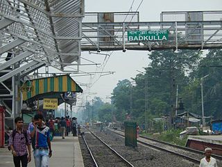
Badkulla is a census town in the Hanskhali CD block in the Ranaghat subdivision of the Nadia district in the Indian state of West Bengal.

<span class="mw-page-title-main">Hanshkhali</span> Village in West Bengal, India

Hanskhali is a village in the Hanskhali CD block in the Ranaghat subdivision of the Nadia district in the state of West Bengal, India. Situated on the bank of the Churni river, Hanshkhali is known for an Administrative Registry Office and Police Station.

Ranaghat Subdivision is an administrative subdivision located at Nadia district, in the state of West Bengal, India.741159. The subdivision is administered by SDM/SDO(Ranaghat).

Chapra is a census town and a gram panchayat in the Chapra CD block in the Krishnanagar Sadar subdivision of the Nadia district in the state of West Bengal, India.

Majdia is a census town in the Nabadwip CD block in the Krishnanagar Sadar subdivision of the Nadia district in the state of West Bengal, India.

Harinadibhastsala is a census town in the Santipur CD block in the Ranaghat subdivision of the Nadia district in the state of West Bengal, India.

Ghoralia is a census town in the Santipur CD block in the Ranaghat subdivision of the Nadia district in the state of West Bengal, India.

Beharia is a census town in the Santipur CD block in the Ranaghat subdivision of the Nadia district in the state of West Bengal, India.

Gangni is a census town in the Ranaghat I CD block in the Ranaghat subdivision of the Nadia district in the state of West Bengal, India.

Kamgachhi is a census town in the Ranaghat I CD block in the Ranaghat subdivision of the Nadia district in the state of West Bengal, India.

Panpara is a census town in the Ranaghat I CD block in the Ranaghat subdivision of the Nadia district in the state of West Bengal, India.

Anulia is a census town in the Ranaghat I CD block in the Ranaghat subdivision of the Nadia district in the state of West Bengal, India.

Halalpur Krishnapur is a census town in the Ranaghat II CD block in the Ranaghat subdivision of the Nadia district in the state of West Bengal, India.

Belgharia is a census town in the Ranaghat II CD block in the Ranaghat subdivision of the Nadia district in the state of West Bengal, India.

References

  1. "District Census Handbook Nadia, Census of India 2011, Series 20, Part XII A" (PDF). Map of Hanskhali CD block, page 397. Directorate of census Operations V, West Bengal. Retrieved 8 October 2020.
  2. Gangopadhyay, Basudev, Paschimbanga Parichay, 2001, (in Bengali), p. 70, Sishu Sahitya Sansad
  3. "District Census Handbook, Nadia, 2011, Series 20, Part XII A" (PDF). Pages 13,14. Directorate of Census Operations, West Bengal. Retrieved 16 October 2020.
  4. "District Statistical Handbook 2014 Nadia". Table 2.2, 2.4(a). Department of Planning and Statistics, Government of West Bengal. Retrieved 16 October 2020.
  5. "2011 Census – Primary Census Abstract Data Tables". West Bengal – District-wise. Registrar General and Census Commissioner, India. Retrieved 8 October 2020.
  6. "Provisional Population Totals, Census of India 2011" (PDF). Constituents of Urban Agglomeration Having Population Above 1 Lakh. Census of India 2011. Retrieved 18 October 2020.
  7. "District Census Handbook Nadia, Census of India 2011, Series 20, Part XII A" (PDF). Section II Town Directory, Pages 635-656; Statement I: Status and Growth History, Page 635; Statement II: Physical Aspects and Location of Towns, Page 641; Statement III: Civic and other Amenities, Page 643; Statement IV: Medical Facilities, Page 646; Statement V: Educational, Recreational and Cultural Facilities, Page 655; Statement VI:Industry and Banking ,Page 2833. Directorate of census Operations V, West Bengal. Retrieved 30 September 2020.