West Bengal, a state in eastern India, is divided into administrative districts that function as the basic units of governance and administration. As of 2024, West Bengal comprises 23 districts, each headed by a District Magistrate or Deputy Commissioner, responsible for general administration and revenue collection. Law and order in each district is maintained by a Superintendent of Police.[1]
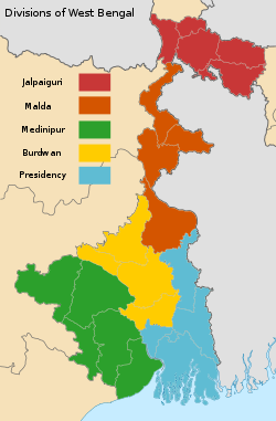
The districts are grouped into five administrative divisions: Presidency, Medinipur, Burdwan, Malda, and Jalpaiguri. These divisions help in facilitating more effective governance.[2]
Districts in West Bengal vary widely in terms of population, area, and economic activity. Some districts encompass major urban centres such as Kolkata, while others are predominantly rural. The creation of new districts, such as Alipurduar in 2014[3] and Jhargram in 2017,[4] reflects ongoing efforts to improve administrative efficiency and local governance.
The following is a comprehensive list of the districts of West Bengal, ordered alphabetically or by their respective divisions.
West Bengal is bordered by three countries: Nepal, Bhutan and Bangladesh; and five Indian states: Sikkim, Bihar, Jharkhand, Odisha, and Assam. Sikkim and Bhutan are located to the north of the state, Nepal to the northwest, Bihar and Jharkhand in the west, Odisha in the southwest, the Bay of Bengal to the south, and Bangladesh and Assam are in the east. West Bengal is the only state of India that has both snowy mountains (Himalayas in the north) and sea beaches (on the coast of the Bay of Bengal in the south). In between them, the river Ganga enters the state from west, before it branches off into its main distributaries: the Hooghly River, which flows southwards to reach the Bay of Bengal, and the Padma River, which flows eastwards into Bangladesh.
The districts that are located at the north of the Ganga—Darjeeling, Jalpaiguri, Cooch Behar, Malda, Uttar Dinajpur, Dakshin Dinajpur, Alipurduar and Kalimpong — are often referred to collectively as North Bengal. Kalimpong is a newly added district of West Bengal.[5] Geographically, this area is divided into the Darjeeling Himalayan hill region, the Terai and Dooars region, and the North Bengal plains.[5] The Siliguri Corridor, also known as Chicken's Neck, which connects North-East India with rest of the India, lies in this region. The Indo-Bangladesh enclaves are either enclaves or exclaves of the Cooch Behar district or the Jalpaiguri district.[6]
The uninhabited South Talpatti Island, which surfaced in the Bay of Bengal in the 1970s near the Indo-Bangladesh border, is claimed by both India and Bangladesh.[7]
History
After India gained independence in 1947, the province of Bengal was partitioned along religious lines. The western part remained in India (and was named West Bengal) while the eastern part joined newly formed Pakistan as a province called East Pakistan (later giving rise to Bangladesh in 1971).[8] At the time of its creation in 1947, the state of West Bengal was divided into 14 districts—Bankura, Birbhum, Burdwan, Calcutta (Kolkata), Darjeeling, Jalpaiguri, Hooghly, Howrah, Malda, Midnapore, Murshidabad, Nadia, West Dinajpur and 24 Parganas.[9] Cooch Behar district was a princely state named Koch Bihar till 20 August 1949, when the state formally agreed to join India. Transfer of administration was started on 12 September 1949 and was completed on 19 January 1950, when Cooch Behar became a district of West Bengal.[10] Chandannagar, which was earlier part of the French India, had voted to join India in a plebiscite in 1949. Formally, it joined India in 1952 and finally became a part of the Hooghly district of West Bengal on 2 October 1954.[11] The States Reorganisation Act of 1956 reorganised boundaries of the Indian states along linguistic lines. As this act was implemented, the then West Dinajpur district was enlarged with the addition of some areas from Bihar, and the Purulia district was formed on 1 November 1956 from parts of the Manbhum district of Bihar.[12]
Later, some large districts were divided into smaller districts. On 1 March 1986, the district of 24 Parganas was bifurcated into two districts—the North 24 Parganas district and the South 24 Parganas district.[13] On 1 April 1992, the West Dinajpur district was bifurcated into the Uttar Dinajpur district and the Dakshin Dinajpur district.[14][15] On 1 January 2002, the erstwhile Midnapore district was bifurcated into the Purba Medinipur district and the Paschim Medinipur district.[16]
Since 2007, the demand for a separate Gorkhaland state has been revived by the Gorkha Janmukti Morcha and its supporters in the Darjeeling hills.[17] The Kamtapur People's Party and its supporters' movement for a separate Kamtapur state that covers the North Bengal has also gained momentum in the 2000s.[18]
A district is governed by a District Collector, who is better known as a District Magistrate (DM) in the state of West Bengal.[19] A DM is an officer from either Indian Administrative Service (IAS) or West Bengal Civil Service (WBCS), and is appointed by the State Government of West Bengal.[19] Each district is divided into subdivisions, except the Kolkata district, which contains urban area only, administered by Kolkata Municipal Corporation. A subdivision is governed by a sub-divisional magistrate (SDM), better known as a Sub-Divisional Officer (SDO).[20] Other than urban units such as town municipalities, a subdivision contains 'community development blocks' (also known as CD blocks or blocks or Tehsil or Taluka). A block consists of urban units such as census towns and rural units called gram panchayats. A block is administered by a Block Development Officer (BDO),who is similar as Tehsildar and who is appointed by the Government of West Bengal.[19]
A gram panchayat, which consists of a group of villages, is administered by a village council headed by a Pradhan.[21] As per the West Bengal Panchayat Act, 1973, each Block has a Panchayat Samiti, whose members include the Pradhans of the constituent gram panchayats, and the MLAs from the block.[22] A Panchayat Samiti is headed by a Sabhapati.[23] The third tier of the Panchayati Raj is Zilla Parishad, a district level organisation with the Sabhapatis of the constituent Panchayat Samitis and the MLAs from the district as its members.[24] A Zilla Parishad is headed by a Sabhadhipati.[25] For the Darjeeling district, the Zilla Parishad has ceased to exist, but a similar organisation for the Siliguri subdivision exists, which is designated as a Mahakuma Parishad.[26]
The Gorkha Hill Council, formed in 1988, administers three (out of four) subdivisions of the Darjeeling district: Darjeeling Sadar, Kalimpong and Kurseong.[27] Gorkha Hill Council manages the departments of Public Health, Education, Public Works, Transport, Tourism, Market, Small scale industries, Agriculture, Agricultural waterways, Forest (except reserved forests), Water, Livestock, Vocational Training and Sports and Youth services.[28] District administration of Darjeeling, which is still responsible for election, panchayat, law and order, revenue etc., also acts as an interface between the Council and the State Government.[28]
A District Superintendent of Police, better known as a Superintendent of Police, heads the District Police organisation of West Bengal Police. This is as per the Police Act of 1861, which is applicable to the whole of India.[29] The Superintendents of Police are officers of the Indian Police Service.[30] For every subdivision, there is a Subdivision Police, headed by a Police officer of the rank of Assistant Superintendent of Police or Deputy Superintendent of Police.[31] Under subdivisions, there are Police Circles, each headed by an Inspector of Police.[31] A Police Circle consists of Police Stations, each headed by an Inspector of Police, or in case of rural areas, by a Sub-Inspector of Police.[31]
The Calcutta High Court has the jurisdiction of the state of West Bengal. Though most of the districts have more courts other than a District Court, not every subdivision of the state has a Court.[32]
A group of districts forms a division, which is administered by a 'Divisional Commissioner'. West Bengal is now divided in twenty three districts, grouped under five divisions:[33]
The following is a list of the basic demographic data for the districts of West Bengal at the time of the 2011 census by their population rank in India[39]
↑ Here 'Established' means year of establishment as a district of West Bengal. The state of West Bengal was established in 1947 with 14 districts of erstwhile Bengal province of British India.
This page is based on this Wikipedia article Text is available under the CC BY-SA 4.0 license; additional terms may apply. Images, videos and audio are available under their respective licenses.