List of districts of Odisha

Last updated

Districts of Odisha
ଓଡ଼ିଶାର ଜିଲ୍ଲାସମୂହ
Odisha districts map.svg
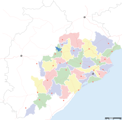
Odisha Political Map
Category Districts
Location Odisha
Number30 districts
Populations Debagarh – 3,12,520 (lowest); Ganjam – 35,29,031 (highest)
Areas Mayurbhanj – 10,418 km2 (4,022 sq mi) (largest); Jagatsinghpur – 1,759 km2 (679 sq mi) (smallest)
Government
Subdivisions
  • Sub-Divisions,Tahasils,

Odisha, a state on the eastern coast of India, is divided into 30 administrative geographical units called Districts . [1] [2] [3] These 30 districts have been placed under three different revenue divisions to streamline their governance. The divisions are Central, North and South with their headquarters at Cuttack (Central Division), Sambalpur (Northern Division), Berhampur (Southern Division) respectively. Each division consists of 10 districts, and has as its administrative head a Revenue Divisional Commissioner (RDC), a senior rank officer of Indian Administrative Service. The position of the RDC in the administrative hierarchy is that between that of the district administration and the state secretariat. Each District is governed by a Collector & District Magistrate, who is appointed from the Indian Administrative Service. The Collector & District Magistrate is responsible for collecting the revenue and maintaining law and order in the district. Each District is separated into Sub-Divisions, each governed by a Sub-Collector & Sub-Divisional Magistrate. The Sub-Divisions are further divided into Tahasils. The Tahasils are headed by Tahasildar. Odisha has 03 Divisions, 30 Districts, 58 Sub-Divisions, 317 Tahasils and 314 Blocks.

Contents

List of districts by divisions

Map of districts of Odisha.
.mw-parser-output .legend{page-break-inside:avoid;break-inside:avoid-column}.mw-parser-output .legend-color{display:inline-block;min-width:1.25em;height:1.25em;line-height:1.25;margin:1px 0;text-align:center;border:1px solid black;background-color:transparent;color:black}.mw-parser-output .legend-text{}
Northern Division
Central Division
Southern Division Odisha districts map.svg
Map of districts of Odisha.
  Northern Division
  Central Division
  Southern Division

The 30 districts of Odisha have been placed under three different revenue divisions to streamline their governance. The divisions are Central, North and South with their headquarters at Cuttack (Central Division), Sambalpur (Northern Division), Berhampur (Southern Division) respectively. Each division consists of 10 districts, and has as its administrative head a Revenue Divisional Commissioner (RDC), a senior rank officer of Indian Administrative Service. The position of the RDC in the administrative hierarchy is that between that of the district administration and the state secretariat. The list of districts, organized by divisions:

Northern Division (HQ – Sambalpur)Central Division (HQ – Cuttack)Southern Division (HQ – Berhampur)

Administration

Collector & District Magistrate is an Indian Administrative Service (IAS) Officer in charge of revenue collection and administration of a district and Superintendent of Police (SP), an officer of Indian Police Service (IPS) is responsible for maintaining law and order and related issues of a district in Odisha.

Districts

There are 30 districts in Odisha. Mayurbhanj is the largest district and Jagatsinghpur is the smallest district by area. Ganjam is the largest district and Deogarh is the smallest district by population in Odisha. Bhubaneswar, the capital city of Odisha is located in Khordha district. The area and population of the 30 districts are given below: [4] [5]

Proposed Districts

There are demands for about 28 districts. Most notable new district forming demands are given below. [7]

Related Research Articles

<span class="mw-page-title-main">Odisha</span> State in Eastern India

Odisha, formerly Orissa, is an Indian state located in Eastern India. It is the eighth-largest state by area, and the eleventh-largest by population, with over 41 million inhabitants. The state also has the third-largest population of Scheduled Tribes in India. It neighbours the states of Jharkhand and West Bengal to the north, Chhattisgarh to the west, and Andhra Pradesh to the south. Odisha has a coastline of 485 kilometres (301 mi) along the Bay of Bengal in the Indian Ocean. The region is also known as Utkaḷa and is mentioned by this name in India's national anthem, Jana Gana Mana. The language of Odisha is Odia, which is one of the Classical languages of India.

<span class="mw-page-title-main">Brahmapur, Odisha</span> City in Odisha, India

Brahmapur is a city on the eastern coastline of Odisha, India.

<span class="mw-page-title-main">Mayurbhanj district</span> District in Odisha, India

Mayurbhanj district is one of the 30 districts in the Odisha state of eastern India. It holds the distinction of being the largest district in Odisha by area. The district's headquarters is located in Baripada, with other major towns including Rairangpur, Karanjia, and Udala. As of 2011, Mayurbhanj ranks as the third-most populous district in Odisha, following Ganjam and Cuttack. Mayurbhanj District Comptises of 04 subdivision namely SADAR Sub-Division with Headquarter at Baripada, Bamanghaty Sub-Division with head quarter at Rairangpur, Panchpidh with headquarter at Karanjia and Kaptipada Sub-Division with headquarter at Udala. The District Has a total of 26 blocks and Tahasils, the Highest in Odisha.

<span class="mw-page-title-main">Koraput district</span> District of Odisha in India

Koraput district is a district of India in southern Odisha, with headquarters at Koraput. The district is located in the Eastern Ghats and is known for its hilly terrain, rich and diverse types of mineral deposits and its tribal culture and traditions. The district headquarters town of Koraput and its largest city, Jeypore are major centres of trade and commerce for South Odisha and fall on an important road connecting Visakhapatnam to Raipur.

<span class="mw-page-title-main">Ganjam district</span> District of Odisha in India

Ganjam district is a district in the Indian state of Odisha. Ganjam's total area is 8,206 km² (3,168 mi²). The district headquarters is Chhatrapur. Ganjam is divided into three sub-divisions Chhatrapur, Berhampur, and Bhanjanagar. The Imperial Gazetteer of India 1908 lists Ganjam, along with the Thanjavur and South Canara districts, as the three districts of the Madras Presidency where Brahmins were most numerous. As of 2011 it is the most populous district of Odisha.

<span class="mw-page-title-main">Cuttack district</span> District in Odisha, India

Cuttack district is one of the 30 districts of Odisha state in India. It is located in the coastal part of the state and its administrative headquarters are located in the city of Cuttack. As of 2011 Census, after Ganjam, it is the second most populous district of Odisha, with a population of 2,624,470. The name is an anglicized form of Kataka or Katak meaning Fort – referring to the Barabati Fort. The district is bisected by the river Mahanadi and its numerous distributaries and occupies a large portion of the river's delta. It is bounded by the Angul, Dhenkanal, Nayagarh and Khurda districts to the west while its southern and eastern boundaries touch Puri, Jagatsinghpur, Kendrapara and Jajpur districts.

<span class="mw-page-title-main">Angul district</span> District of Odisha in India

Angul district; also known as Anugul, is one of the thirty districts of Odisha in eastern India. The city of Angul is the district headquarters of Angul district. A major industrial hub of the state, the district hosts numerous industries relating to coal, bauxite and steel apart from extensive forests including the Satkosia Tiger Reserve.

<span class="mw-page-title-main">Sub-divisional magistrate</span> Head of a sub-division in India

A sub-divisional magistrate, also known as sub collector, revenue divisional officer, or assistant commissioner, is the administrative head of a sub-division in an Indian district, exercising executive, revenue, and magisterial duties. The specific name depends on the state or union territory. The primary responsibilities include revenue collection, maintaining law and order, overseeing developmental activities and coordinating various departments within a sub-division.

<span class="mw-page-title-main">Puri district</span> District of Odisha in India

Puri district is a coastal district of the Odisha state of India. It has one sub-division, 11 tahasils and 11 blocks and comprises 1722 revenue villages. Puri is the only municipality of the district. Konark, Pipili, Satyabadi, Gop, Kakatpur and Nimapada are the NACs in this district while Brahmagiri being a semi-urban town.

Chhatrapur (ଛତ୍ରପୁର) is a town and a Municipality in Ganjam district in the state of Odisha, India.

Previously a neglected aspect of the Indian Central government, Education in Odisha is witnessing a rapid transformation. Its capital city, Bhubaneswar, is emerging as a knowledge hub in India with several new public and private universities, including the establishment of an Indian Institute of Technology after five decades of demand.

<span class="mw-page-title-main">Odisha Police</span> State police force in India

The Odisha Police abbreviated as either OP or OPS, is the law enforcement agency for the state of Odisha in India. It is headquartered in Cuttack, the former capital of Odisha. The Odisha Police is headed by a Director General of Police, currently Sunil Kumar Bansal, IPS and falls under the purview of the state's Home Department of the Government of Odisha. The sanctioned personnel strength of Odisha Police is 72,145; comprising women as one-third of its total sanctioned strength in the directly recruited posts of civil constable, sub-inspector and deputy superintendent of police. This feat makes it one of the foremost in that aspect among the police services of India.

<span class="mw-page-title-main">Odisha State Road Transport Corporation</span> Indian bus operator

Odisha State Road Transport Corporation or OSRTC is the state owned road transport corporation in the eastern Indian state of Odisha. It is acknowledged for its distinguished service for safe and lowest cost of operation with a fleet of 636 buses.

<span class="mw-page-title-main">Rourkela Junction railway station</span> Railway station in Odisha, India

Rourkela Junction railway station is a railway junction located in the north-western part of the Indian state of Odisha and serves Rourkela in Sundergarh district. Rourkela is the third-largest urban agglomeration in Odisha.

The Odisha Tourism Development Corporation (OTDC) is a Government of Odisha undertaking corporation in the Indian state of Odisha. It was incorporated in the year 1979 to promote tourism in the state and operate some of the existing tourist bungalows and transport fleets in commercial line. OTDC's Tourist Bungalows are called as Panthanivas.

The Odisha State Electricity Regulatory Commission or OERC is a Public Sector Undertaking of Government of Odisha established under the Orissa Electricity Reform (OER) Act, 1995, as a part of the Reform Process in the State of Odisha.

A sub-division is an administrative division of a district in India. In some states(Andhra Pradesh, Telangana, Tamil Nadu, Kerala) they are called Revenue Divisions. It is headed by a sub-divisional magistrate. In some states, the post is designated as Revenue Divisional Officer (RDO) or Sub-Divisional Officer (Civil). A district may have multiple sub-divisions, and each of those sub-divisions may contain multiple sub-districts and municipalities. For example, in West Bengal, the Murshidabad district contains five sub-divisions (mahakumas)

Aparajita Sarangi is an Indian politician from the Bharatiya Janata Party and the incumbent Member of Parliament from Bhubaneswar. A former Odisha cadre Indian Administrative Service (IAS) officer of the 1994 batch, Sarangi quit her job and joined the BJP on 27 November 2018 to contest the 2019 Indian general election. She was fielded against Biju Janata Dal's Arup Patnaik.

<span class="mw-page-title-main">Parvathipuram Manyam district</span> District in Andhra Pradesh, India

Parvathipuram Manyam district is a district in the Indian state of Andhra Pradesh. With Parvathipuram as its administrative headquarters, it became functional from 4th April 2022. The district was formed from Parvathipuram revenue division from Vizianagaram district and part of Palakonda revenue division of Srikakulam district. The district was once part of ancient Kalinga. The famous Kamalingeswara swamy temple was built in the regin of King Rajaraja Deva of Eastern Ganga Dynasty of Odisha in 11th century CE.

References

  1. 1 2 "Districts of Odisha". Official Portal. Bhubaneswar: Government of Odisha. Retrieved 4 January 2013.
  2. "Districts of Orissa". Archived from the original on 16 January 2012. Retrieved 13 January 2012.
  3. "List of Districts" (PDF). Retrieved 13 January 2012.
  4. "Administrative Unit". Revenue & Disaster Management Department, Government of Odisha. Archived from the original on 21 August 2013. Retrieved 27 March 2015.
  5. The Office of Registrar General and Census Commissioner of India.
  6. "List of districts of Orissa". census2011.co.in.
  7. "New district demands".