Districts
The sixteen districts of Manipur state are:
Manipur, a state in India, has sixteen administrative districts.
A district of an Indian state is an administrative geographical unit, headed by a district magistrate or a deputy commissioner, an officer belonging to the Indian Administrative Service. The district magistrate or the deputy commissioner is assisted by a number of officials belonging to different wings of the administrative services of the state.
A superintendent of Police, an officer belonging to Indian Police Service is entrusted with the responsibility of maintaining law and order and related issues.
On 9 December 2016, the government created 7 new districts, bringing the total number of districts to 16. [1]
The sixteen districts of Manipur state are:
| District | Population (2011) [2] | Area (km2) | Density (/km2) |
|---|---|---|---|
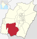
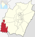
| Bishnupur | 240,363 | 496 | 415 |
| Thoubal | 420,517 | 324 | 713 |
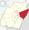
| Imphal East | 452,661 | 497 | 555 |
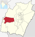
| Imphal West | 514,683 | 519 | 847 |
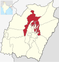
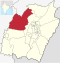
| Senapati | 354,772 | 1,573 | 116 |
| Ukhrul | 183,115 | 2,206 | 31 |
| Chandel | 144,028 | 2,100 | 37 |
| Churachandpur | 271,274 | 2,392 | 50 |
| Tamenglong | 140,143 | 3,315 | 25 |
| Jiribam | 43,818 | 182 | 190 |
| Kangpokpi | 1,698 | ||
| Kakching | 135,481 | 190 | |
| Tengnoupal | 1,213 | ||
| Kamjong | 45,616 | 2,338 | 23 |
| Noney | 1,076 | ||
| Pherzawl | 47,250 | 2,128 | 21 |
| District | Indigenous names of districts | Languages (major) | Languages (minor) |
| Bishnupur | Meitei | Kom*, Kabui | |
| Thoubal | Thoubal | Meitei | Aimol, Anal*, Maring |
| Imphal East | Imphal East | Meitei, Kabui | Tangkhul*, Thadou*, Mao*, Hmar*, Paite*, Gangte*, Vaiphei |
| Imphal West | Imphal West | Meitei, Kabui | Tangkhul*, Thadou*, Mao*, Hmar*, Paite*, Gangte*, Vaiphei |
| Senapati | Tahamzam | Mao*, Poula* | Maram, Thangal, Liangmai, Maram, Rongmai, Inpui, Tangkhul* |
| Ukhrul | Ukhrul | Tangkhul* | Thadou* |
| Chandel | Chandel | Thadou*, Anal*, Lamkang | Maring, Moyon, Monsang, Chothe, Gangte, Tarao, Vaiphei |
| Churachandpur | Lamka | Paite*, Thadou*, Hmar, Vaiphei*, Zou, Gangte | Kom*, Aimol, Chiru, Meitei, Simte |
| Tamenglong | Inriangluang | Rongmei, Liangmei, Zemei, Inpui | Thadou*, Chiru, Hmar* |
| Jiribam | Jiribam | Meitei, Bengali, Hmar* | Rongmei, Thadou*, Paite, Gangte, Vaiphei |
| Kangpokpi (Sadar Hills) | Kanggui | Thadou*, Nepali | Kom*, Liangmai, Thangal, Rongmei, Aimol, Tangkhul*, Koireng, Kharam, Vaiphei, Gangte, Hmar* |
| Kakching | Kakching | Meitei, Loi* | _ |
| Tengnoupal | Tengnoupal | Maring, Thadou*, Gangte | Aimol*, Zou |
| Kamjong | Kamjong | Tangkhul | Thadou* |
| Noney | Longmai | Rongmei, Inpui | Gangte, Vaiphei |
| Pherzawl | Pherzawl | Hmar*, Thadou | Simte, Paite*, Bengali, Vaiphei, Gangte |
| Districts | Subdivisions |
| Bishnupur | Nambol, Moirang, Bishnupur |
| Thoubal | Thoubal, Lilong |
| Imphal East | Porompat, Keirao Bitra, Sawombung |
| Imphal West | Lamshang, Patsoi, Lamphelpat, Wangoi |
| Senapati | Tadubi, Paomata, Purul, Willong, Chilivai Phaibung, Songsong, Lairouching |
| Ukhrul | Ukhrul, Lungchong Maiphai, Chingai, Jessami |
| Chandel | Chandel, Chakpikarong, Khengjoy |
| Churachandpur | churchandpur, Tuiboung, Sangaikot, Mualnuam, Singngat, Henglep, Suangdoh, Kangvai, Samulamlan, Saikot |
| Tamenglong | Tamenglong, Tamei, Tousem |
| Jiribam | Jiribam, Borobekra |
| Kangpokpi (Sadar Hills) | Kangpokpi, Champhai, Saitu Gamphazol, Kangchup Geljang, Tuijang Waichong, Saikul, Lhungtin Island, Bungte Chiru |
| Kakching | Kakching, Waikhong |
| Tengnoupal | Machi, Moreh, Tengnoupal |
| Kamjong | Kamjong, Kasom Khullen, Sahamphung, Phungyar |
| Noney | Nungba, Khoupum, Longmai, Haochong |
| Pherzawl | Pherzawl, Parbung Tipaimukh, Vangai Range, Thanlon |