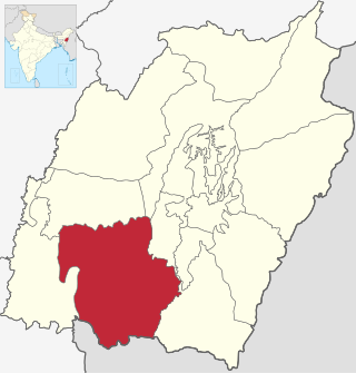
Churachandpur District, is one of the 16 districts of the Indian state of Manipur populated mainly by Kuki-Zo people. The name honours former Maharaja Sir Churachand Singh of Manipur. The district headquarters is located in the Churachandpur town, which is also locally known by the name Lamka.
Jiribam is a town governed by a municipal council in the Jiribam district of the state of Manipur, India. It is one of the fastest-growing towns in Manipur.
Lilong (Thoubal) is a town with Municipal Council in Thoubal District in the Indian state of Manipur.
Wangjing is a town and a municipal council in Thoubal district in the Indian state of Manipur. It is about 6 km from district headquarters and an agricultural town in Thoubal district in the Indian state of Manipur. It is bordered by Heirok village in the east, Tentha village in the south-west, and on the other side by agricultural land. Wangjing River, a rivulet flowing down from the eastern hills, runs through the middle of the town, serving as a natural spring. It is connected to other parts of the state by the Imphal–Moreh national highway. It is the junction between Heirok and Tentha village.
Dadra is one of the two talukas in Dadra and Nagar Haveli district, India. It is an enclave lying a few kilometres north west of Nagar Haveli and is surrounded by Gujarat.
Heirok is a town and a nagar panchayat in Thoubal district in the Indian state of Manipur.

Kaimri is a village in Karauli district of Rajasthan State in India.
Chingai is a village located north of Ukhrul in Ukhrul district, Manipur state, India. The village is one of the seven sub-divisional headquarters of Ukhrul district. The village partially connected by National Highway 150, Imphal-Kohima road via Jessami. Chingai is also one of the 60 Vidhan Sabha constituencies of Manipur and Khashim Vashum is the Member of Ligislative Assembly (MLA) elected from this constituency & Minister of 1.Animal Husbandry & Veterinary Dept. 2. Transportation dept. of government of Manipur.[ The village is flanked by Awang Kasom in the west, Khamasom in the south, Somrah Tract in the east and Kharasom in the north.
Phungyar is a small town located south of Kamjong in Kamjong district, Manipur state, India. It is also the name of a sub division of the district. The town is about 50 kilometers from Ukhrul and is partially connected by National Highway 150 that connects Imphal and Kohima via Ukhrul and Jessami. The town is flanked by Khambi in the south, Loushing in the north and alang in the west. Locally, the inhabitants speak common tangkhul language and native village dialect which belongs to the Tibeto-Burman language family.
Sumchinvum is a small village in Singngat-Sub-Division, Churachandpur District, Manipur, India. It was also known as 'Dimmual' by the Tedim people inhibiting in the village before the Kuki–Paite ethnic clash of 1997–98.
Barni (Barhni) is a small village of Baliah Panchyat of Barsar District Hamirpur, Himachal Pradesh. According to Census 2011 information the location code or village code of Barni village is 017512. Barni village is located in Barsar Tehsil of Hamirpur district in Himachal Pradesh, India. It is situated 35 km away from district headquarter hamirpur. Barsar is the sub-district headquarter of Barni village.
Lasanpur is a large village located in Dagarua of Purnia district, Bihar with total 437 families residing. It has population of 2126 of which 1115 are males while 1011 are females as per Population Census 2011.
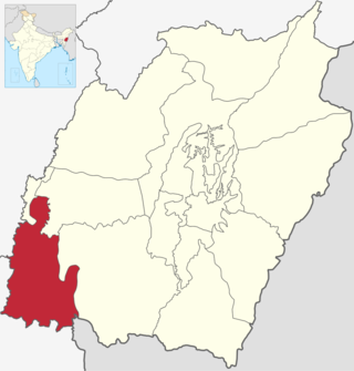
Pherzawl district is located in the southern part of the state of Manipur. It is bounded on the east by Churachandpur District; on the north by Tamenglong District, Noney District and Jiribam district; on the west by the Cachar District of Assam and on the South by Sinlung Hills, Mizoram. Pherzawl District has approximately 200 villages.

Jiribam District is a district at the western periphery state of Manipur, India. It borders the Cachar district of Assam on the west, and serves as the western gateway for Manipur. Formerly a subdivision of the Imphal East district, it was made an independent district in December 2016.
Khamlang village is situated on the southern part of Ukhrul District, Manipur, India. It is inhabited by Khameon a Tangkhul Naga tribe. It is situated 2 km away from headquarter of Sub-Division, Kasom Khullen, 137 km away from district headquarter Ukhrul and 59 km from state capital Imphal, Manipur.
Wangoo is a village in the Kakching district of the Indian state of Manipur. It is situated approximately 64 km south of the state capital, Imphal. It has an area of 13.05 km2 with a population of 6134.

Sipuikawn is a Hmar village in Pherzawl District, Northeast India. It is located in south-western hilly region of Manipur bordering the Indian state of Mizoram. The National Highway 150 passes through the village connecting Mizoram and Manipur. Parbung is also as Sub-Divisional block headquarters and its neighboring villages are Lungthulien, Rawvakawt and Khawpuar (Mizoram). Sipuikawn is also known by its alternate name "Hmarkhawpui".
Bungmual is a village in a Churachandpur district of Manipur, India. It is further sub-divided into "Veng", some of them are Lamlian Veng, Lai Veng, Hausa Veng, New Lane, Colony Veng, Siloam Veng and Zoar Veng,

Taithu, is a Hmar village in Pherzawl district, Northeast India. The National Highway 2 runs through this village connecting Manipur and Mizoram. According to the 2016 House Counting Data from the Government of Manipur, Taithu has 211 households where its population is recorded as 1198, with 601 males and 597 females.
