This article needs additional citations for verification .(September 2014) |
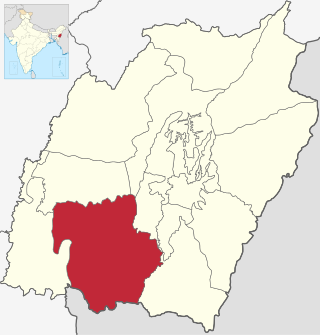
Sadar Hills is a geographic area in the state of Manipur in North East India.
This article needs additional citations for verification .(September 2014) |
Sadar Hills is a geographic area in the state of Manipur in North East India.
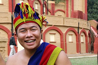
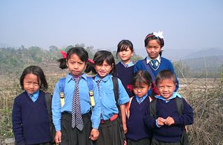
Sadar Hills is inhabited by heterogeneous ethnic groups with inherent socio-economic and cultural backgrounds, including the indigenous Kuki tribes, minor of Nepalis and Nagas. Many of the people are economically underprivileged. As per the Hill House Counting and Grazing Tax assessment of 2012, the total number of villages and population of Sadar Hills in the three sub-divisional wise are shown below: [1]
| Sl/no. | Name of Sub-Division | No. of village | Population |
|---|---|---|---|
| 1. | Kangpokpi-Sadar Hills West | 150 | 60945 |
| 2. | Saitu-Gamphazol | 259 | 44130 |
| 3. | Saikul-Sadar Hills East | 178 | 51438 |
| 4. | Total : | 587 | 156513 |
Sadar Hills has mild climatic conditions. The land has a complete and clear demarcated boundary.
In 1971, during the process for granting full-fledged statehood to Manipur, the government of India passed an Act of Parliament, called Manipur (Hill Areas) Autonomous District Council Act, 1971 (vide Section 4 of Sub-Section 3, Bill No. 76 of 26/12/1971) for safeguarding the hill areas and protection of the tribals in Manipur. The Act provides for creation of six Autonomous District Councils in the hill areas of Manipur for ultimate conversion into full-fledged district, viz.:
In spite of many protests by the Naga people of the area, as of 2016 Sadar Hills had been created as a district. [2] [3]
| Sl/no. | Name Of Sub-Division | Area (in Sq.Km) | No. of village as 2011 Census | Population as of 2011 Census [4] |
|---|---|---|---|---|
| 1. | Kangpokpi-Sadar Hills West | 476 | 150 | 60945 |
| 2. | Saitu-Gamphazol | 457 | 295 | 44130 |
| 3. | Saikul-Sadar Hills East | 765 | 178 | 51438 |
| 4. | Total | 1698 | 623 | 1,56,513 |

Nagaland is a state in the north-eastern region of India. It is bordered by the Indian states of Arunachal Pradesh to the north, Assam to the west, Manipur to the south, and the Naga Self-Administered Zone of the Sagaing Region of Myanmar (Burma) to the east. Its capital city is Kohima and its largest city is the twin Chümoukedima–Dimapur. The state has an area of 16,579 square kilometres (6,401 sq mi) with a population of 1,980,602 as per the 2011 Census of India, making it one of the smallest states of India.

Manipur is a state in northeast India, with the city of Imphal as its capital. It is bounded by the Indian states of Nagaland to the north, Mizoram to the south and Assam to the west. It also borders two regions of Myanmar, Sagaing Region to the east and Chin State to the south. The state covers an area of 22,327 km2 (8,621 sq mi). The official and most widely spoken language is the Meitei language. Native to the Meitei people, it is also used as a lingua franca by smaller communities, who speak a variety of other Tibeto-Burman languages. Manipur has been at the crossroads of Asian economic and cultural exchange for more than 2,500 years. This exchange connects the Indian subcontinent and Central Asia to Southeast Asia, East Asia, Siberia, regions in the Arctic, Micronesia and Polynesia enabling migration of people, cultures and religions.

The Insurgency in Northeast India involves multiple separatist and jihadist militant groups operating in some of India's northeastern states, which are connected to the rest of India by the Siliguri Corridor, a strip of land as narrow as 14.29 miles (23.00 km) wide.
Churachandpur District, is one of the 16 districts of the Indian state of Manipur populated mainly by Kuki-Zo people. The name honours former Maharaja Sir Churachand Singh of Manipur. The district headquarters is located in the Churachandpur town, which is also locally known by the name Lamka.
The Paite people are an ethnic group in Northeast India, mainly living in Manipur and Mizoram. The Paites are recognized as a scheduled tribe in these two states. They are part of the larger Zo people, but also use their Zomi identity along with all the 7 tribes under 'Zomi Council' . "Guite" is a major clan of the Paite people.

Bishnupur district or Bishenpur district, is a district of Manipur state in northeastern India.

Chandel district is one of the 16 districts of Manipur state in northeastern India. Its headquarters is the town of Chandel. In December 2016, a part of the district was split to establish the new Tengnoupal district. The district is mainly populated by Kuki-Zo and Old Kuki/Naga tribal people.

Senapati, is one of the 16 districts of the Indian state of Manipur. The present Senapati district was formed in December 2016, after spawning off the Sadar Hills region in the south into a separate Kangpokpi district. The district headquarter is located in the municipality of Tahamzam.

Thoubal district is one of the sixteen districts of Manipur state in northeastern India. This district is bounded by Imphal East on the north, Kangpokpi District and Tengnoupal District districts on the east, Kakching district on the south and Imphal West district on the west. The district occupies an area of 324 km2. The population as of 2011 is 286,687. Thoubal town is the district headquarters. This district is known for Khongjom, where the last battle of the independence of Manipur was fought in April 1891 against the British army.

Ukhrul district is an administrative district of the state of Manipur in India with its headquarters at Ukhrul. The Ukhrul district has a long history dating back to the 1920s when it was created as the North-East Hill Sub-Division of the then princely state of Manipur. In 2016, the Kamjong subdivision of the Ukhrul district was spun out as a separate district, leading to the present configuration of the Ukhrul district.

Imphal West district is one of the sixteen districts of Manipur state in northeastern India. As of 2011, it is the most populous district in the state.

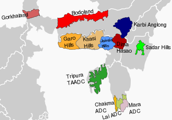
In India, there are autonomously administered territories for Scheduled Tribes, administered by representatives of those tribes. The Sixth Schedule of the Constitution of India allows for the formation of Autonomous District Councils and Autonomous Regional Councils in Assam, Meghalaya, Mizoram, and Tripura, granting them autonomy within their respective territories. Currently, there are 10 Autonomous District Councils across these four states. In these areas, Acts of Parliament and state legislation do not apply.
The Kuki–Paite Conflict, also called Kuki–Zomi Conflict, was an ethnic conflict during 1997–1998 between tribal communities in Churachandpur district in Manipur, India. The conflict started when a Kuki insurgent group, KNF, mercilessly killed 10 Paite villagers of Saikul Village on June 24, 1997, which led to pitting one group that subscribed to the Kuki label against another group that subscribed to the Zomi label, the latter being led by the Paites. The conflict lasted for over a year, during which 352 people died, thousands of homes were destroyed and over 13,000 people were displaced. The Government of India sent in the Indian Army to attempt to stop the violence, but peace was restored in September–October 1998 only with the initiative of the Church.
The Naga Hills District was a former district of the Assam province of British India. Located in the Naga Hills, it was mainly inhabited by the Naga ethnic groups. The area is now part of the state of Nagaland.
The Mate people are one of the Kuki tribes of Manipur, India. The Mates – a name, in its literal sense, connotes front beaters and consequently, in the broadest sense as a designation, implies a migratory people – are a little-known tribal community of Manipur, India, whose socio-cultural identity as a distinct tribe was only recently recognised by the Union Government of India and the State Government of Manipur. The Mates achieved recognition as a scheduled tribe in January 2012.
Jadonang Malangmei (1905–1931), popularly known as Haipou Jadonang, was a Naga spiritual leader and political activist from Manipur, British India. He established the Heraka religious movement, which was based on the ancestral Naga religion, and declared himself to be the "messiah king" of the Nagas. His movement was widespread in the Zeliangrong territory before the conversion to Christianity. He also espoused the cause of an independent Naga kingdom, which brought him in conflict with the colonial British rulers of India. He was hanged by the British in 1931, and succeeded by his cousin Rani Gaidinliu.

Purul is a village in Senapati district, Manipur, India. Whereas Purul is the name given by other people, Hiimai ki is the name given by its own inhabitants. 'Hiimai' refers to its people and 'ki' to a place/land, meaning land of Hiimai. The predominant inhabitants belong to Poumai Naga tribe. The village consists of two contiguous habitations viz Purul Akutpa & Purul Atongba . As per the latest census of India in 2011, 99.4% of the people follow Christianity and the rest follow naturism. And literacy rate is 74%. Purul is bordered by Phuba (North), Shirong (East), Oinam Hill(West) and Koide (South). At the village level, each of Purul Akutpa and Purul Atongba is administered by a selected person known as Village Chairman assisted by Secretary and other persons. These administrators are collectively known as Village Authority, similar to Panchayat/Sarpanch. At Zila level, 27 villages including Purul is administered by a Sub-divisional Officer (SDO)/Teshildar, whose office is located at the village. Among the 27 villages, Purul Akutpa is most populous with 6168 persons. The SDO works under the District Magistrate (DM/DC), Senapati. One elected person represent Purul in the Autonomous District Council (ADC), Senapati. Purul along with Oinam Hill, Phuba, Koide, Karong and other areas are represented at Manipur State level by one Member of Legislative Assembly (MLA). Name of the constituency is 47,Karong Legislative Assembly Constituency. It is the 47th of total 60 legislative constituencies of the Manipur state. Purul is 20 km from the nearest town i.e. Maram, which is located on the highway, NH-2. It is 45 km from District Headquarters, 112 km from the nearest airport, 140 km from the nearest railway station. Medical practitioner/physicians and other medical personnels are stationed at the Nearest Primary Health Centre (PHC), Oinam Hill. The PHC is 10 km from Purul. The village has one government higher secondary school, one private secondary school and five government primary schools.
The Anāl is a Naga tribe native to Manipur state in North-East India and part of Myanmar. They are listed as a Scheduled Tribe, in accordance with The Scheduled Castes and Scheduled Tribes Orders (Amendment) Act, 1976 Indian Constitution. The Anāl tribe is one of the 'sixty six Naga tribes' of the Naga ancestral homeland. The members of this tribe are found both in India and Myanmar. In India, they are situated in the States of Manipur and Nagaland but mostly concentrated in the former. In the State of Manipur, the Anāl Naga population concentrated in Chandel and a few Anāl villages are located in its neighbouring districts, Churachandpur district has about three villages and Thoubal district has one or two.
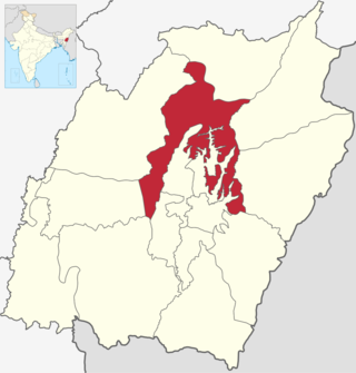
Kangpokpi district is one of the 16 districts in the Indian state of Manipur. It was created in December 2016 from areas in the Sadar Hills region which were previously part of Senapati District.
The hill tribes of Northeast India are hill people, mostly classified as Scheduled Tribes (STs), who live in the Northeast India region. This region has the largest proportion of scheduled tribes in the country.
| 6th Schedule areas (Constitution of India) |
| ||||||||
|---|---|---|---|---|---|---|---|---|---|
| Non-6th Schedule areas (State legislation) |
| ||||||||
| Central India |
|  |
|---|---|---|
| East India | ||
| North India |
| |
| Northeast India |
| |
| South India |
| |
| West India |
| |