
Manipur is a state in northeast India, with the city of Imphal as its capital. It is bounded by the Indian states of Nagaland to the north, Mizoram to the south and Assam to the west. It also borders two regions of Myanmar, Sagaing Region to the east and Chin State to the south. The state covers an area of 22,327 km2 (8,621 sq mi). The official and most widely spoken language is the Meitei language. Native to the Meitei people, it is also used as a lingua franca by smaller communities, who speak a variety of other Tibeto-Burman languages. Manipur has been at the crossroads of Asian economic and cultural exchange for more than 2,500 years. This exchange connects the Indian subcontinent and Central Asia to Southeast Asia, East Asia, Siberia, regions in the Arctic, Micronesia and Polynesia enabling migration of people, cultures and religions.
Northeast India, officially the North Eastern Region (NER), is the easternmost region of India representing both a geographic and political administrative division of the country. It comprises eight states—Arunachal Pradesh, Assam, Manipur, Meghalaya, Mizoram, Nagaland and Tripura, and the "brother" state of Sikkim.
Ri Bhoi is an administrative district in the state of Meghalaya in India. The district headquarters are located at Nongpoh. The district occupies an area of 2378 km² and has a population of 258,840. As of 2011 it is the second least populous district of Meghalaya, after South Garo Hills.
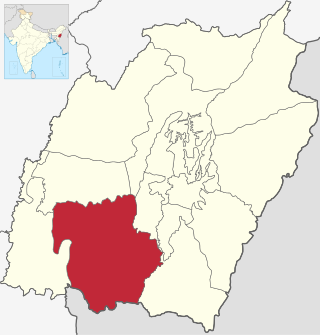
Churachandpur District, is one of the 16 districts of the Indian state of Manipur populated mainly by Kuki-Zo people. The name honours former Maharaja Sir Churachand Singh of Manipur. The district headquarters is located in the Churachandpur town, which is also locally known by the name Lamka.
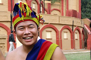
The Paite people are an ethnic group in Northeast India, mainly living in Manipur and Mizoram. The Paites are recognized as a scheduled tribe in these two states. They are part of the larger Zo people, but also use their Zomi identity along with all the 7 tribes under 'Zomi Council' . "Guite" is a major clan of the Paite people.

The Kuki people, or Kuki-Zo people, are an ethnic group in the Northeastern Indian states of Manipur, Nagaland, Assam, Meghalaya, Tripura and Mizoram, as well as the neighbouring countries of Bangladesh and Myanmar. The Kukis form one of the largest hill tribe communities in this region. In Northeast India, they are present in all states except Arunachal Pradesh. The Chin people of Myanmar and the Mizo people of Mizoram are kindred tribes of the Kukis. Collectively, they are termed the Zo people.
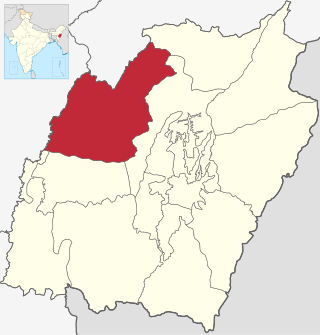
Tamenglong district is one of the 16 districts of Manipur state in northeastern India. In 2011, Tamenglong was the least populous district in Manipur. In 2016, the Nungba subdivision was separated as a separate district.Tamenglong district is also the largest district of Manipur in 2024 with an area of 3,315 km2.

Ukhrul district is an administrative district of the state of Manipur in India with its headquarters at Ukhrul. The Ukhrul district has a long history dating back to the 1920s when it was created as the North-East Hill Sub-Division of the then princely state of Manipur. In 2016, the Kamjong subdivision of the Ukhrul district was spun out as a separate district, leading to the present configuration of the Ukhrul district.
Moreh is a border town located on the India–Myanmar border in Tengnoupal district of the Indian state of Manipur. As a rapidly developing international trade point with the integrated customs and international immigration checkpoint, Moreh plays an important role in India's Look East Policy, trade and commerce under ASEAN–India Free Trade Area, India-Myanmar relationship, India–Myanmar–Thailand road connectivity, and Trans-Asian Railway connectivity.
Zo is a Northern Kuki-Chin-Mizo language originating in western Burma and spoken also in Mizoram and Manipur in northeastern India.
The Zo people is a term to denote the ethnolinguistically related speakers of the Kuki-Chin languages who primarily inhabit northeastern India, western Myanmar, and southeastern Bangladesh.
Maring people, are a Tibeto-Burman ethnic group of Northeast Indian state of Manipur. They live in the Chandel district along the north border and in the Tengnoupal district. They speak the Maring language. The Marings identify with the Naga people. The Marings do not have a system of hereditary chiefs.
Paite is a Sino-Tibetan language spoken by the Paite people. There are different Paite dialects; some notable Paite dialects are Bukpi, Lousau, Valpau, Dapzal, Tuichiap, Sukte, Dim, Lamzang and Sihzang. The language exhibits mutual intelligibility with the other languages of the region including Thadou, Hmar, Vaiphei, Simte, Kom, Gangte and other languages. The name Paite could translate to 'the people who went', 'a group of people marching'. Paite refers to a group of people who enter today Manipur and Mizoram (India) crossing the run river during the pre colonial era, so the word Paite itself means "those who went out".... It is fairly necessary to note that there are amongst those group of people who do not leave today Burma and still settle there. They cannot be called Paite since they do not leave or set out, So to put an umbrella term on all the ethnic groups between two international countries the word "Zomi" is unifiedly used. They are a part of the Chin/Kuki/Mizo/Zomi (CHIKIMZO)

The Kharam people, also known as the Kharam Naga's, are inhabiting the Northeast Indian state of Manipur. They are recognised as a Scheduled Tribe (STs) by India. They use Meitei language as their second language (L2) according to the Ethnologue.

Chiru is a Kuki-Chin language spoken mostly in Manipur. The Chiru population numbers approximately 8,599. It is an endangered spoken in three districts of Manipur: Senapati, Noney district of Manipur and Cachar district of Assam. Chiru has been recognized as a Scheduled Tribe of Manipur by the government of India since 1956 under "The Scheduled Castes and Scheduled Tribes Orders (Amendment) Act, Act No. 63 of 1956" Dated 25 September 1956. The total population of the native speakers of Chiru is only 8599. The native speakers have high proficiency in Meitei language. The language is neither used in schools nor in radio or mass media. Older people read and write in Meitei language. The younger generation of Chiru speakers prefers Roman script.
Ranglong is an ethnic people belonging to the Kuki people. The majority of the Ranglong people live in a small and densely-packed area in the northeastern part of India, mainly in the border areas of Tripura, Assam and Mizoram.

Aimol, also known as Aimual, is a Sino-Tibetan language spoken by the Aimol people of Manipur, India. It is considered endangered and has less than 9,000 speakers worldwide as per 2011 census. The speakers of this language use Meitei language as their second language (L2) according to the Ethnologue.
The Anāl is a Naga tribe native to Manipur state in North-East India and part of Myanmar. They are listed as a Scheduled Tribe, in accordance with The Scheduled Castes and Scheduled Tribes Orders (Amendment) Act, 1976 Indian Constitution. The Anāl tribe is one of the 'sixty six Naga tribes' of the Naga ancestral homeland. The members of this tribe are found both in India and Myanmar. In India, they are situated in the States of Manipur and Nagaland but mostly concentrated in the former. In the State of Manipur, the Anāl Naga population concentrated in Chandel and a few Anāl villages are located in its neighbouring districts, Churachandpur district has about three villages and Thoubal district has one or two.
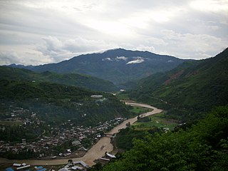
Noney, also known as Longmai, is a town located in the western part of Manipur, India. It is 63 kilometres (39 mi) west of Imphal, the capital of the state of Manipur. Its population is almost entirely made up of Rongmei Naga. Previously known as a village, recently has been declared as one of the new district headquarters of Manipur and is separated from the existing Tamenglong District and now comprises Haochong, Khoupum, Nungba and the Longmai subdivision.
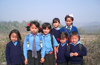
The hill tribes of Northeast India are hill people, mostly classified as Scheduled Tribes (STs), who live in the Northeast India region. This region has the largest proportion of scheduled tribes in the country.

