Mamit district | |
---|---|
Coordinates(Mamit): 23°55′31″N92°29′29″E / 23.925141°N 92.491368°E | |
Country | India |
State | Mizoram |
Headquarters | Mamit |
Government | |
• Lok Sabha constituencies | Mizoram |
• Vidhan Sabha constituencies | 3 |
Area | |
• Total | 3,025 km2 (1,168 sq mi) |
Population (2011) | |
• Total | 86,364 |
• Density | 29/km2 (74/sq mi) |
Demographics | |
• Literacy | 84.93 |
• Sex ratio | 927 |
Time zone | UTC+05:30 (IST) |
Website | mamit |
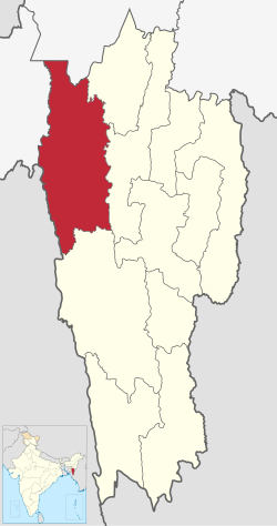
Mamit district is one of the eleven districts of Mizoram state in India.
The district is bounded on the north by Hailakandi district of Assam state, on the west by North Tripura district of Tripura state and Bangladesh, on the south by Lunglei district and on the east by Kolasib and Aizawl districts. The district occupies an area of 3025.75 km². Mamit town is the administrative headquarters of the district. [1]
Year | Pop. | ±% p.a. |
---|---|---|
1971 | 30,311 | — |
1981 | 52,255 | +5.60% |
1991 | 64,572 | +2.14% |
2001 | 62,785 | −0.28% |
2011 | 86,364 | +3.24% |
source: [2] |
According to the 2011 census Mamit district has a population of 86,364, roughly equal to the nation of Andorra. [4] This gives it a ranking of 618th in India (out of a total of 640). The district has a population density of 29 inhabitants per square kilometre (75/sq mi). Its population growth rate over the decade 2001-2011 was 37.56%. Mamit has a sex ratio of 927 females for every 1000 males, and a literacy rate of 84.93%. 17.25% of the population lives in urban areas. 95.04% of the population belongs to Scheduled Tribes. [1]
According to the 2011 census, 62.61% of the population spoke Mizo, 17.64% Tripuri, 15.25% Chakma and 1.92% Bengali as their first language. [5]
Indian has set up several Border Haats (markets) and ICP (Integrated Check Posts) in Mizoram to boost the border trade and Look-East connectivity to Trans-Asian Railway and Asian Highway Network (via AH1). [6] [7] Marpara and Tuipuibari on Bangladesh–India border are two ICP in Mamit district. [8]
In 1985 Mamit district became home to Dampa Tiger Reserve, which has an area of 500 km². [9]
Karimganj district is one of the 35 districts of the Indian state of Assam. Karimganj town is both the administrative headquarters district and the biggest town of this district. It is located in southern Assam and borders Tripura and the Sylhet Division of Bangladesh. It makes up the Barak Valley alongside Hailakandi and Cachar. Karimganj was previously part of the Sylhet District before the Partition of India. It became a district in 1983.
West Tripura is an administrative district in the state of Tripura in India. The district headquarters are located at Agartala. As of 2012 it is the most populous district of Tripura.
Sheohar is an administrative district in the Mithila region of Bihar in India. The district headquarters are located at Sheohar, and the district is a part of Tirhut Division. This district was carved out of Sitamarhi district in 1994 due to the extreme efforts of Raghunath Jha, former Union Minister. Eminent Hindi Novelist, Dr. Bhagwati Sharan Mishra was the first District magistrate of Sheohar. Sivas used to have a guest house in the Mehsi town of his time, which is still located in the name of Raja Bazar in East Champaran.The district occupies an area of 349 km2 and has a population of 656,246. Sheohar is known for its greenery and cleanliness. Cadamba and teak are the principal trees of this district. Nilgai or blue bull is the regional animal of this area.
Jamtara district is one of the twenty-four districts of Jharkhand state in eastern India. Jamtara town is the administrative headquarters of this district. The district is situated between 23°10′ and 24°05′ north latitudes and 86°30′ and 87°15′ east longitudes.
Bulandshahr district is a district in the Meerut region in the north Indian state of Uttar Pradesh (UP), situated between the Ganga and Yamuna rivers. It is a part of the National Capital Region of India, and Bulandshahr is the district headquarters.
Ayodhya district is one of the 75 districts in the northern Indian state of Uttar Pradesh. The city of Ayodhya is its administrative headquarters. The district occupies an area of 2,522 square kilometres (974 sq mi), and had a population of 2,470,996 in the 2011 census. Ayodhya district shares its borders with 6 districts of Uttar Pradesh. It is bordered by Gonda and Basti districts on the northern side, Amethi and Sultanpur districts on the south, and Ambedkar Nagar and Barabanki districts share the border on the east and west.
Jalpaiguri district is a district of the Indian state of West Bengal. The district was established in 1869 during British Raj. The headquarters of the district are in the city of Jalpaiguri, which is also the divisional headquarters of Jalpaiguri division.
Kannauj district is an administrative district of Uttar Pradesh state in northern India, along the river Ganges. The historic town of Kannauj, northwest of Kanpur, is the administrative center. The district was carved out of Farrukhabad district on 18 September 1997. The native dialect of this district is Kannauji.
Gorakhpur district is one of the 75 districts of Uttar Pradesh state in northern India. This district is a part of the Gorakhpur division. The city of Gorakhpur, or Gorakhpur is the administrative headquarters of this district and Gorakhpur division. It borders Sant Kabir Nagar district to the west, Kushinagar and Deoria districts to the east, and Maharajganj and Azamgarh districts to the north and south.
Lunglei district is one of the eleven districts of Mizoram state in India. As of 2011 it is the second most populous district in the state, after Aizawl.
Kolasib district is one of the eleven districts of Mizoram state in India.
Serchhip district is one of the eleven districts of Mizoram state in India. The district occupies an area of 1421.60 km2. Serchhip town is the administrative headquarters of the district. This district came into existence on 15 September 1998, being carved out of the larger Aizawl District. Because of the way it was created it includes part of East Lungdar Tehsil and part of Thingsulthliah Tehsil.
Siaha district is one of the eleven districts of Mizoram state in India. The district is bounded on the northwest by Lunglei district, on the north and west by Lawngtlai District and on the south and east by Myanmar. The district occupies an area of 1399.9 km2. Siaha town is the administrative headquarters of the Mara Autonomous District Council. The population had Increased from 56,574 to 67,658. It is the least populous district of Mizoram.
Lawngtlai district is one of the eleven districts of Mizoram state in India.
Barnala is one of the districts of Indian state of Punjab. It was carved out of Sangrur district, in November 2006. It is a centrally located district bordered by Ludhiana district on the north, Moga district on northwest, Bathinda district on west, Sangrur district on east and Mansa district on south. As per census 2011, the population of District Barnala is 5,96,294. The town has a thriving industrial sector with two main industries: Trident Group and a large industry producing Combines.
Bijapur District, formerly known as Birjapur, is one of the 27 districts of the state of Chhattisgarh in central India. It is one of the two new districts created on May 11, 2007. As of 2011 it is the second least populous district of Chhattisgarh, after Narayanpur. It is the second-least literate district in India, with a literacy rate of at 41.58%, according to the 2011 census.
Zote is a village in Champhai block of Champhai District, Mizoram state, India.
Khowai district is a district of Tripura state of India. This district was created in January, 2012 when four new districts were created in Tripura, taking the number of districts in the state from four to eight. The district headquarters are located in the town Khowai. The district was carved out of West Tripura district along with new Sipahijala district. The district is divided into two subdivisions, namely Khowai and Teliamura.
Zokhawthar is a border town in the Champhai district of Mizoram state of India.
The Republic of India shares borders with several sovereign countries; it shares land borders with China, Bhutan, Nepal, Pakistan, Bangladesh, and Myanmar. Bangladesh, Myanmar, and Pakistan share both land borders as well as maritime borders, while Sri Lanka shares only a maritime border through Ram Setu. India's Andaman and Nicobar Islands share a maritime border with Thailand, Myanmar, and Indonesia.
198 Andorra 84,825 July 2011 est.