The Indo-Tibetan Border Police (ITBP) is a paramilitary border guarding force of India deployed along its borders with Tibet Autonomous Region. It is one of the five Central Armed Police Forces, established in 1962 in the aftermath of the Sino-Indian War of 1962.

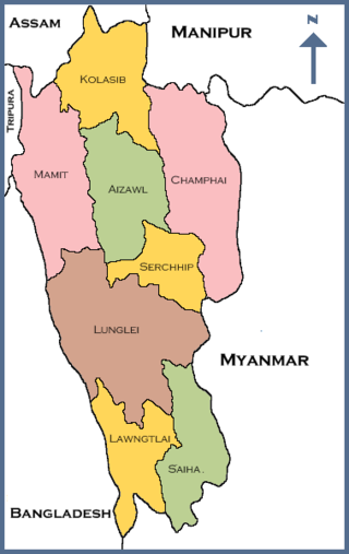
Mizoram is a state in northeastern India, with Aizawl as its seat of government and largest city. Within India's northeast region, it is the southernmost state, sharing borders with three of the Seven Sister States, namely Tripura, Assam and Manipur, and also shares a 722-kilometre (449 mi) border with the neighbouring countries of Bangladesh and Myanmar. The state spans over an area of approximately 21,087 square kilometres, of which approximately 91% is forested. With an estimated population of 1.25 million in 2023, it is the second least populous state in the country.

Jungle warfare or woodland warfare is warfare in forests, jungles, or similar environments. The term encompasses military operations affected by the terrain, climate, vegetation, and wildlife of densely-wooded areas, as well as the strategies and tactics used by military forces in these situations and environments.
Tezu is a census town and the headquarters of Lohit district in the Indian state of Arunachal Pradesh. It is the fifth largest town in Arunachal Pradesh and one of its most developed.

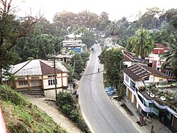
Kolasib is a town located in the northern part of Mizoram, India. It serves as the headquarters of the Kolasib District. Situated along the border with the state of Assam, Kolasib is an important transit point connecting Mizoram with the rest of India. The town is known for its strategic location and serves as a gateway to Mizoram from the neighboring state.

The Counter-Insurgency and Jungle Warfare School (CIJWS) in Vairengte, Mizoram, India is a training and research establishment of the Indian Army specialising in unconventional warfare, especially counter-insurgency and guerrilla warfare. CIJWS is one of the premier counter-insurgency training institutions in the world.

The Marine Commandos, abbreviated to MARCOS and officially called the Marine Commando Force (MCF), are the special forces of the Indian Navy. The MARCOS were originally named Indian Marine Special Force, which was later changed to Marine Commando Force to impart "an element of individuality" to it, according to the Indian Navy. The abbreviation 'MARCOS' was coined afterwards.
The Indian Defence services have established numerous academies and staff colleges across India for the purpose of training professional soldiers in military sciences, warfare command and strategy, and associated technologies.
Villukuri is a small village in Kanyakumari district, Tamil Nadu, India.

Kolasib district is one of the eleven districts of Mizoram state in India.

Mamit district is one of the eleven districts of Mizoram state in India.

Serchhip district is one of the eleven districts of Mizoram state in India. The district occupies an area of 1421.60 km2. Serchhip town is the administrative headquarters of the district. This district came into existence on 15 September 1998, being carved out of the larger Aizawl District. Because of the way it was created it includes part of East Lungdar Tehsil and part of Thingsulthliah Tehsil.
Champhai district is one of the eleven districts of Mizoram state in India. The district is bounded on the north by Churachandpur district of Manipur state, on the west by Saitual and Serchhip districts, and on the south and east by Myanmar. The district occupies an area of 3,185.83 km2 (1,230.06 sq mi). Champhai town is the administrative headquarters of the district.

Lawngtlai is a town located in the southern part of Mizoram, India. It serves as the administrative headquarters of the Lawngtlai district and is home to the Pawi people, also known as the Hakha Chin people in Myanmar. Lawngtlai celebrates a variety of indigenous festivals, such as the Hlukhla Kut, similar to that of Chapchar Kut.
The Mizo National Front uprising was a revolt against the government of India aimed at establishing a sovereign nation state for the Mizo people, which started on 28 February 1966. On 1 March 1966, the Mizo National Front (MNF) made a declaration of independence, after launching coordinated attacks on the Government offices and security forces post in different parts of the Mizo district in Assam. The government retaliated and recaptured all the places seized by the MNF by 25 March 1966.
Builum is a village in Bilkhawthlir Block of Kolasib district of Mizoram state of India. The village was established in the year 1941, but had to be moved as the construction of Serlui B dam on the Serlui river between 2003 and 2009 submerged the original village. The compensations due to the villagers due to the construction of the Serlui B dam are still ongoing.
Rajivnagar is a large village located in Zawlnuam of Mamit district, Mizoram with total 708 families residing. The Rajivnagar village has population of 3530 of which 1796 are males while 1734 are females as per Population Census 2011. Rajiv nagar also known as Aamsury is an important business center for local Chakma people.

The following outline is provided as an overview of and topical guide to Mizoram:
Khamlang village is situated on the southern part of Ukhrul District, Manipur, India. It is inhabited by Khameon a Tangkhul Naga tribe. It is situated 2 km away from headquarter of Sub-Division, Kasom Khullen, 137 km away from district headquarter Ukhrul and 59 km from state capital Imphal, Manipur.
Captain Brijesh Chowta is an Indian politician and the Member of Parliament, Lok Sabha from Dakshina Kannada Lok Sabha constituency. He is a member of the Bharatiya Janata Party on 4 June 2024.