Kolasib

Last updated

Kolasib
Town
Kolasib-535106 0.JPG
Kolasib, mizoram
Location map India Mizoram EN.svg
Red pog.svg
Kolasib
India location map.svg
Red pog.svg
Kolasib
Coordinates: 24°13′52″N92°40′34″E / 24.23111°N 92.67611°E / 24.23111; 92.67611
CountryIndia
State Mizoram
District Kolasib
Government
  BodyDistrict Collector : John LT Sanga
Elevation
888 m (2,913 ft)
Population
 (2023)
  Total34,200
Languages
  Official Mizo
Time zone UTC+5:30 (IST)
PIN
796081 [1]
Vehicle registration MZ 05
Climate Cwa
Website mizoram.nic.in

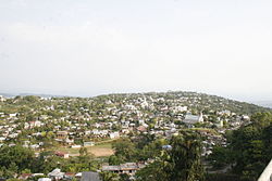
Kolasib is a town located in the northern part of Mizoram, India. It serves as the headquarters of the Kolasib District. Situated along the border with the state of Assam, Kolasib is an important transit point connecting Mizoram with the rest of India. The town is known for its strategic location and serves as a gateway to Mizoram from the neighboring state.

Contents

Demographics

[ needs update ] As of the 2011 Census of India, [2] Kolasib district had a population of 83,955.

Economy

Kolasib is agriculture-dominated economy with a few service sector jobs as it is a district capital. A large number of people cultivate betel nut, oil palms, rice, wheat and fish which is both consumed and exported to other districts of Mizoram. [3]

Transport

A helicopter service by Pawan Hans [4] has been started which connects the Aizawl with Kolasib. [5] The distance between Kolasib and Aizawl through NH 54 is 83 km and is connected with regular service of bus and Maxi-Cabs. [6]

Media

The Major Newspapers in Kolasib are: [7]

Major Television Cable Network in Kolasib are:

Related Research Articles

<span class="mw-page-title-main">Mizoram</span> State in northeastern India

Mizoram is a landlocked state in northeast India, with Aizawl as its seat of government and largest city. Within India's northeast region, it is the southernmost state, sharing borders with three of the Seven Sister States, namely Tripura, Assam and Manipur, and also shares a 722-kilometre (449 mi) border with the neighbouring countries of Bangladesh and Myanmar. The state spans over an area of approximately 21,087 square kilometres, of which approximately 91% is forested. With an estimated population of 1.25 million in 2023, it is the second least populous state in the country.

<span class="mw-page-title-main">Siaha</span> Town in Mizoram, India

Siaha is a town and headquarters of Siaha District and the Mara Autonomous District Council in southern Mizoram, northeast India. It is the fourth most populous town in Mizoram.

<span class="mw-page-title-main">Vairengte</span> Town in Mizoram, India

Vairengte is a town located in the Kolasib district of the Indian state of Mizoram. It is situated in the northeastern part of the state, at the border with the state of Assam. Vairengte is known for being the location of the Counter Insurgency and Jungle Warfare School (CIJWS), which is operated by the Indian Army. Due to its strategic location at the Assam-Mizoram border and its association with the CIJWS, Vairengte holds a unique position in the state of Mizoram.

<span class="mw-page-title-main">Lunglei</span> Town in Mizoram, India

Lunglei, formerly known as Lungleh, is the second-largest town situated in the south-central part of Mizoram, northeastern India. The city served as the capital of British Mizoram from 1889 to 1898. Due to its location, it has been serving as a commercial hub for southern Mizoram.

<span class="mw-page-title-main">Champhai</span> Town in Mizoram, India

Champhai is the third largest town in Mizoram, northeast India and is one of the oldest settlements founded by the Mizo people, that initially served as a capital for the Hmar dynasty. It serves as a hub for trade and commerce in the region as the town's strategic location near the India–Myanmar border facilitates cross-border trade, contributing to its economic vibrancy.

Bairabi is a census town in Kolasib district in the state of Mizoram, India.

Hnahthial is the headquarters of Hnahthial district in the Indian state of Mizoram. The term Hnahthial is a Mizo term which means Phrynium capitatum, a plant which grows in plenty in Hnahthial.

Khawzawl is a census town in Khawzawl district in the Indian state of Mizoram.

<span class="mw-page-title-main">Mamit, India</span> Town in Mizoram, India

Mamit is a census town in Mamit district in the Indian state of Mizoram.

<span class="mw-page-title-main">Serchhip</span> Town in Mizoram, India

Serchhip is a town located in the Indian state of Mizoram, in the northeastern part of the country. It serves as the headquarters of the Serchhip district.

Thenzawl is a census town in Serchhip district in the Indian state of Mizoram. It is a center for the traditional Mizo handloom industry.

<span class="mw-page-title-main">Lengpui Airport</span> Airport in Aizawl, India

Lengpui Airport is a domestic airport serving Aizawl, the capital of Mizoram, India. It is located at Lengpui in the Mamit district of the state. The airport is connected by flights to Delhi, Kolkata, Guwahati, Imphal and Silchar and is located at a distance of 32 km from Aizawl. Lengpui Airport is the first airport in the country to be built by the State Government.

<span class="mw-page-title-main">Kolasib district</span> District of Mizoram in India

Kolasib district is one of the eleven districts of Mizoram state in India.

<span class="mw-page-title-main">Lawngtlai</span> Town in Mizoram, India

Lawngtlai is a town located in the southern part of Mizoram, India. It serves as the administrative headquarters of the Lawngtlai district and is home to the Pawi people, also known as the Hakha Chin people in Myanmar. Lawngtlai celebrates a variety of indigenous festivals, such as the Hlukhla Kut, similar to that of Chapchar Kut.

<span class="mw-page-title-main">New Serchhip</span> Town in Mizoram, India

New Serchhip is the northern extension of Serchhip Town in Mizoram State of India. It was created and inhabited since 1976.

<span class="mw-page-title-main">Lammual Stadium</span> Football stadium in Mizoram, India

Lammual Stadium is a football stadium located in Aizawl, Mizoram, India. It is used mainly for football matches. It was one of the venues for the Northeast Games 2012. The stadium is used for playing Mizoram Premier League matches.

<span class="mw-page-title-main">Aizawl</span> Capital city of the Indian state Mizoram

Aizawl, formerly known as Aijal, is the capital city and the most populous city of Mizoram, India. It is also the third largest city in northeast India after Guwahati and Agartala. It is situated atop a series of ridges, with an average elevation of around 1,132 metres above sea level. In 2024, the city has an estimated population of 405,000 people.

Hnahthial district is one of the eleven districts of Mizoram state in India. The creation of Hnahthial District was first notified on 12 September 2008 but until 2020, it remained non-functional despite a number of promises made by top political leaders and an all-out effort by Hnahthial District Function Demand Committee to let the state government make it functional. Hnahthial district was made functional only 12 years later on 3 June 2019 with the creation of the office of the Deputy Commissioner.

Khawzawl district is one of the eleven districts of Mizoram state in India. Khawzawl district was recently created on 3 June 2019.

References

  1. "Kolasib PIN Code Number, India". askkaka.in. Archived from the original on 7 November 2017. Retrieved 30 October 2017.
  2. "Census of India 2001: Data from the 2001 Census, including cities, villages and towns (Provisional)". Census Commission of India. Archived from the original on 16 June 2004. Retrieved 1 November 2008.
  3. "Economic activity gains momentum in Mizoram's Kolasib District". Yahoo News. Retrieved 29 August 2012.
  4. "MIZORAMA HELICOPTER SERVICE TUR CHIEF MINISTER IN HAWNG". Mizoram DIPR. Archived from the original on 12 December 2013. Retrieved 14 August 2012.
  5. "Nilaini atangin 'Helicopter Service". The Zozam Times. Archived from the original on 23 September 2015. Retrieved 20 August 2012.
  6. "Aizawl to Shillong". Mizoram NIC. Retrieved 29 August 2012.
  7. "Accredited Journalists". DIPR Mizoram. Archived from the original on 19 June 2013. Retrieved 5 September 2012.
  8. "Accredited Journalists". DIPR Mizoram. Archived from the original on 19 June 2013. Retrieved 5 September 2012.
  9. "RNI Registration". Archived from the original on 3 June 2016. Retrieved 19 May 2016.