Kolasib district

Last updated

Kolasib district
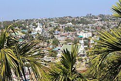
Kolasib, Mizoram - panoramio.jpg
View of Kolasib
Kolasib in Mizoram (India).svg
Location in Mizoram
Kolasib district
Kolasib district
Country India
State Mizoram
Headquarters Kolasib
Government
   Lok Sabha constituencies Mizoram
   Vidhan Sabha constituencies 3
Area
  Total1,382.51 km2 (533.79 sq mi)
Population
 (2011)
  Total83,955
  Density61/km2 (160/sq mi)
Demographics
   Literacy 93.50
  Sex ratio956
Time zone UTC+05:30 (IST)
Website kolasib.nic.in

Kolasib district is one of the eleven districts of Mizoram state in India.

Contents

Geography

Hydrology

Kolasib district has one completed Dam, Serlui B Dam [1] and two under construction Bairabi Dam [2] and Tuirial Dam Construction recommenced in September 2011. [3]

Demographics

Historical population
YearPop.±% p.a.
197126,983    
198138,432+3.60%
199148,769+2.41%
200165,960+3.07%
201183,955+2.44%
source: [4]
Religions in Kolasib district (2011) [5]
ReligionPercent
Christianity
89.58%
Islam
5.27%
Hinduism
4.76%
Other or not stated
0.39%

According to the 2011 census Kolasib district has a population of 83,955, roughly equal to the nation of Andorra. [6] This gives it a ranking of 620th in India (out of a total of 640). The district has a population density of 61 inhabitants per square kilometre (160/sq mi). Its population growth rate over the decade 2001-2011 was 27.28%. Kolasib has a sex ratio of 956 females for every 1000 males, and a literacy rate of 93.50%. 55.84% of the population lives in urban areas. Scheduled Tribes make up 87.67% of the population. [7]

Languages spoken in Kolasib district (2011) [8]

   Mizo (75.93%)
   Hmar (7.56%)
   Bengali (5.30%)
   Tripuri (4.63%)
   Nepali (1.90%)
   Hindi (1.33%)
  Others (3.35%)

According to the 2011 census, 75.93% of the population spoke Mizo, 7.56% Hmar, 5.30% Bengali, 4.63% Tripuri, 1.90% Nepali and 1.33% Hindi as their first language. [8]

Related Research Articles

<span class="mw-page-title-main">Una district</span> A district in Himachal Pradesh, India

Una district is a district in the Indian state of Himachal Pradesh. Una shares its border with the Hoshiarpur and Rupnagar districts of Punjab and Kangra, Hamirpur, and Bilaspur districts of Himachal Pradesh. The terrain is generally plain with semi hills.

<span class="mw-page-title-main">Narmada district</span> District of Gujarat in India

Narmada district is an administrative district in the state of Gujarat in India. The district headquarters are located at Rajpipla. The district is bounded by Vadodara and Chhota Udaipur districts in the north, by Nandurbar district of Maharashtra state in the east, by Surat and Tapi districts in the south and by Bharuch district in the west. The district occupies an area of 2,755 km² and has a population of 590,297. It was 10.44% urban as of 2011. As of 2011, it is the third least populous district of Gujarat, after Dang and Porbandar.

<span class="mw-page-title-main">Simdega district</span> District of Jharkhand in India

Simdega district is one of the 24 districts of Jharkhand state, India, and Simdega town is the administrative headquarters of this district. As of 2011, this district is the least densely populated district and the third least populous district of Jharkhand after Lohardaga and Khunti districts. Simdega District was carved out from erstwhile Gumla district on 30 April 2001. It is currently a part of the Red Corridor.

<span class="mw-page-title-main">Sahebganj district</span> District of Jharkhand in India

Sahibganj district is one of the twenty-four districts of Jharkhand state, India, and Sahibganj is the administrative headquarters of this district.

<span class="mw-page-title-main">Jamtara district</span> District of Jharkhand in India

Jamtara district is one of the twenty-four districts of Jharkhand state in eastern India. Jamtara town is the administrative headquarters of this district. The district is situated between 23°10′ and 24°05′ north latitudes and 86°30′ and 87°15′ east longitudes.

<span class="mw-page-title-main">Aligarh district</span> District of Uttar Pradesh in India

Aligarh district is a district in the state of Uttar Pradesh, India. This district is a part of Aligarh Division. The districts which adjoin Aligarh are Gautam Buddha Nagar, Bulandshahr, Sambhal, Badaun, Kasganj, Hathras and Mathura.

<span class="mw-page-title-main">Ayodhya district</span> District of Uttar Pradesh in India

Ayodhya district is an administrative district of the Indian state of Uttar Pradesh. The city of Ayodhya is its administrative headquarters. The district occupies an area of 2,522 square kilometres (974 sq mi), and had a population of 2,470,996 in the 2011 census. Ayodhya district shares its borders with 6 districts of Uttar Pradesh. It is bordered by Gonda and Basti districts on the northern side, Amethi and Sultanpur districts on the south, and Ambedkar Nagar and Barabanki districts share the border on the east and west.

<span class="mw-page-title-main">Hathras district</span> District of Uttar Pradesh in India

Hathras district is a district of Uttar Pradesh state of India. The city of Hathras is the district headquarters. Hathras district is a part of Aligarh division. The district occupies an area of 1,840 square kilometres (710 sq mi) and has a population of 1,564,708 as of the 2011 census.

<span class="mw-page-title-main">Kanpur Nagar district</span> District of Uttar Pradesh in India

Kanpur Nagar district, meaning Urban Kanpur District is one of the districts of the Uttar Pradesh state of India. It is a part of Kanpur division and its district headquarters is Kanpur. Kanpur was formerly spelled Cawnpore.

<span class="mw-page-title-main">Burhanpur district</span> District of Madhya Pradesh in India

Burhanpur District is a district of Madhya Pradesh state in central India. The city of Burhanpur is the district headquarters.

<span class="mw-page-title-main">Chittorgarh district</span> District of Rajasthan in India

Chittorgarh district is one of the 33 districts of Rajasthan state in western India. The historic city of Chittaurgarh is the administrative headquarters of the district. The district was established on 1 August 1948 by integrating portions of various princely states: Mewar, Pratabgarh, Tonk, and Jhalawar. Chittaurgarh is famous for the Chittor fort, home to various famous Rajput dynasties.

Bairabi is a census town in Kolasib district in the state of Mizoram, India.

<span class="mw-page-title-main">Dhamtari district</span> District of Chhattisgarh in India

Dhamtari is a district of the Indian state of Chhattisgarh. This district is situated at 20°42' N latitude and 81°33' E longitude. Dhamtari district was officially formed on 6 July 1998 by trifurcating Raipur district into Raipur, Dhamtari and Mahasamund districts.

<span class="mw-page-title-main">Lunglei district</span> District of Mizoram in India

Lunglei district is one of the eleven districts of Mizoram state in India. As of 2011 it is the second most populous district in the state, after Aizawl.

<span class="mw-page-title-main">Mamit district</span> District of Mizoram in India

Mamit district is one of the eleven districts of Mizoram state in India.

<span class="mw-page-title-main">Serchhip district</span> District of Mizoram in India

Serchhip District is one of the eleven districts of Mizoram state in India. The district occupies an area of 1421.60 km2. Serchhip town is the administrative headquarters of the district. This district came into existence on 15 September 1998, being carved out of the larger Aizawl District. Because of the way it was created it includes part of East Lungdar Tehsil and part of Thingsulthliah Tehsil.

<span class="mw-page-title-main">Saiha district</span> District of Mizoram in India

Siaha District is one of the eleven districts of Mizoram state in India. The district is bounded on the northwest by Lunglei district, on the north and west by Lawngtlai District and on the south and east by Myanmar. The district occupies an area of 1399.9 km2. Siaha town is the administrative headquarters of the Mara Autonomous District Council. The population had decreased from 60,823 to 56,574. It is the least populous district of Mizoram.

<span class="mw-page-title-main">Lawngtlai district</span> District of Mizoram in India

Lawngtlai district is one of the eleven districts of Mizoram state in India.

<span class="mw-page-title-main">Fatehgarh Sahib district</span> District of Punjab in India

Fatehgarh Sahib district is one of the twenty-three districts of the state of Punjab, India, with its headquarters in the town of Fatehgarh Sahib.

<span class="mw-page-title-main">Outline of Mizoram</span> Overview of and topical guide to Mizoram

The following outline is provided as an overview of and topical guide to Mizoram:

References

  1. "SerluiB A Milestone in the Power Sector". Eastern Panorama. 20 October 2010. Archived from the original on 18 February 2013. Retrieved 8 August 2012.
  2. Lalfakzuala. "Bairabi Dam Project 80MW leh TLAWNG HEP 55MW TAN MOU ZIAKFEL". DIPR Mizoram. Archived from the original on 8 January 2014. Retrieved 13 August 2012.
  3. "Tuirial Project To Be Completed by 2014". SINLUNG. 11 November 2011. Retrieved 5 August 2012.
  4. Decadal Variation In Population Since 1901
  5. "Table C-01 Population By Religion: Mizoram". census.gov.in. Registrar General and Census Commissioner of India. 2011.
  6. US Directorate of Intelligence. "Country Comparison:Population". Archived from the original on 13 June 2007. Retrieved 1 October 2011. 198 Andorra 84,825 July 2011 est.
  7. "District Census Handbook: Kolasib" (PDF). censusindia.gov.in. Registrar General and Census Commissioner of India. 2011.
  8. 1 2 "Table C-16 Population By Mother Tongue: Mizoram". censusindia.gov.in. Registrar General and Census Commissioner of India. 2011.

24°13′48″N92°40′48″E / 24.23000°N 92.68000°E / 24.23000; 92.68000