
India is the most populous country in the world with one-sixth of the world's population. According to the UN estimates, India has overtaken China in having the largest population in the world with population of 1,425,775,850 at the end of April 2023.
Madipakkam is residential locality situated in south of Chennai, India. It has been recently placed under the Greater Chennai Corporation.
Thiruneermalai is a neighborhood in the city of Tambaram, situated within the Chennai Metropolitan Area, Tamil Nadu, India.

Meerut district, is one of the districts of Uttar Pradesh state of India, and Meerut is the district headquarters. Meerut district is also a part of the Meerut division. The administrative head of district of Meerut is a District Magistrate while the administrative head of Meerut Division is Divisional Commissioner, an IAS officer.
Athipattu is a census town in Chennai in Thiruvallur district in the state of Tamil Nadu, India. The neighbourhood is served by Athipattu railway station of the Chennai Suburban Railway network. it is a suburb in northern part of Chennai.
In India and some other countries, a census town is designated as a town that satisfies certain characteristics.

Injambakkam is a locality in the south of Chennai in the Indian state of Tamil Nadu. Being a part of the Walajabad block of the district, its panchayat is part of Walajabad panchayat union. Injambakkam is located along the ECR.
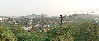
Peerkankaranai is a neighborhood in the city of Tambaram, situated within the Chennai Metropolitan Area, Tamil Nadu, India.
The Delimitation commission or Boundary commission of India is a commission established by the Government of India under the provisions of the Delimitation Commission Act. The main task of the commission is redrawing the boundaries of the various assembly and Lok Sabha constituencies based on a recent census. The representation from each State is not changed during this exercise. However, the number of SC and ST seats in a state are changed in accordance with the census. The present delimitation of constituencies has been done on the basis of 2001 census under the provisions of Delimitation Act, 2002.
RannaBelagali is a Pattan Panchayat Town in the southern state of Karnataka, India. It is located in the Mudhol taluka of Bagalkot district in Karnataka
Nagaral(ನಾಗರಾಳ) is a village in the southern state of Karnataka, India. It is located in the Bilagi taluk of Bagalkot district in Karnataka. It is about 35 kilometres (22 mi) from the district headquarters of Bagalkot town and is about 5 kilometres (3.1 mi) from taluka headquarters of Bilagi and on the left bank of the Krishna River. It is famous for the Digamabareshwara temple and well educated persons.
The 2001 census of India was the 14th in a series of censuses held in India every decade since 1871.

The 2011 census of India or the 15th Indian census was conducted in two phases, house listing and population enumeration. The House listing phase began on 1 April 2010 and involved the collection of information about all buildings. Information for National Population Register (NPR) was also collected in the first phase, which will be used to issue a 12-digit unique identification number to all registered Indian residents by Unique Identification Authority of India. The second population enumeration phase was conducted between 9 and 28 February 2011. Census has been conducted in India since 1872 and 2011 marks the first time biometric information was collected. According to the provisional reports released on 31 March 2011, the Indian population increased to 1.21 billion with a decadal growth of 17.70%. Adult literacy rate increased to 74.04% with a decadal growth of 9.21%. The motto of the census was Our Census, Our Future.
Aldhal is a village in Belgaum district in the southern state of Karnataka, India. Administratively, it is part of the Naganur K D gram panchayat in Hukeri Taluka.
Ingalagi is a panchayat village in Belgaum district in the southern state of Karnataka, India.

