
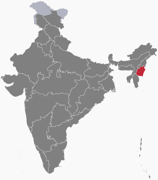
Manipur is a state in northeast India, with the city of Imphal as its capital. It is bounded by the Indian states of Nagaland to the north, Mizoram to the south and Assam to the west. It also borders two regions of Myanmar, Sagaing Region to the east and Chin State to the south. The state covers an area of 22,327 km2 (8,621 sq mi). The official and most widely spoken language is the Meitei language. Native to the Meitei people, it is also used as a lingua franca by smaller communities, who speak a variety of other Tibeto-Burman languages. Manipur has been at the crossroads of Asian economic and cultural exchange for more than 2,500 years. This exchange connects the Indian subcontinent and Central Asia to Southeast Asia, East Asia, Siberia, regions in the Arctic, Micronesia and Polynesia enabling migration of people, cultures and religions.
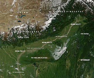
Northeast India, officially the North Eastern Region (NER), is the easternmost region of India representing both a geographic and political administrative division of the country. It comprises eight states—Arunachal Pradesh, Assam, Manipur, Meghalaya, Mizoram, Nagaland and Tripura, and the "brother" state of Sikkim.

The Keibul Lamjao National Park is a national park in the Bishnupur district of the state of Manipur in Northeast India. It is 40 km2 (15.4 sq mi) in area, the only floating national park in the world, and an integral part of Loktak Lake. It is currently under the tentative lists of the UNESCO World Heritage Sites, under the title "Keibul Lamjao Conservation Area (KLCA)", additionally covering the buffer of Loktak Lake and Pumlen Pat.

Imphal East district is one of the 16 districts of Manipur state in northeastern India. In 2011, it was the second most populous district in the state, after Imphal West. In 2016, the Jiribam subdivision, which was an exclave at the western periphery of the state, was separated as an independent district.
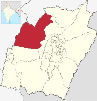
Tamenglong district is one of the 16 districts of Manipur state in northeastern India. In 2011, Tamenglong was the least populous district in Manipur. In 2016, the Nungba subdivision was separated as a separate district.Tamenglong district is also the largest district of Manipur in 2024 with an area of 3,315 km2.

Thoubal district is one of the sixteen districts of Manipur state in northeastern India. This district is bounded by Imphal East on the north, Kangpokpi District and Tengnoupal District districts on the east, Kakching district on the south and Imphal West district on the west. The district occupies an area of 324 km2. The population as of 2011 is 286,687. Thoubal town is the district headquarters. This district is known for Khongjom, where the last battle of the independence of Manipur was fought in April 1891 against the British army.

The Northeast India-Myanmar pine forests is a montane subtropical coniferous forest ecoregion in the mountains of Northeastern India and adjacent portions of Myanmar.
Jiribam is a town governed by a municipal council in the Jiribam district of the state of Manipur, India. It is one of the fastest-growing towns in Manipur.
This article discusses the geological origin, geomorphic characteristics, and climate of the northeastern Indian state of Assam. Extending from 89° 42′ E to 96° E longitude and 24° 8′ N to 28° 2′ N latitude, it has an area of 78,438 km2, similar to that of Ireland or Austria.
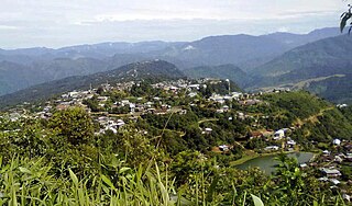
Tamenglong is a town in the Naga hills of Manipur and the district headquarter of the Tamenglong district.
The Zeliangrong people are one of the major indigenous Naga communities living in the tri-junction of Assam, Manipur and Nagaland in India. They are the descendants of Nguiba. The term "Zeliangrong" refers to the Zeme, Liangmai and Rongmei Kindred tribes combined. Earlier, the term also covered the Inpui tribe. The descendants of Hoi of Makuilongdi (Makhel) were divided and were made peripheral appendages to three political entities - Nagaland, Manipur and the Dima Hasao of Assam. The Zeliangrong may be classified as an ethno-cultural entity. The Zeliangrong belong to the larger Southern Mongoloid population and their language belongs to the Sino-Tibetan family of languages.
Jadonang Malangmei (1905–1931), popularly known as Haipou Jadonang, was a Naga spiritual leader and political activist from Manipur, British India. He established the Heraka religious movement, which was based on the ancestral Naga religion, and declared himself to be the "messiah king" of the Nagas. His movement was widespread in the Zeliangrong territory before the conversion to Christianity. He also espoused the cause of an independent Naga kingdom, which brought him in conflict with the colonial British rulers of India. He was hanged by the British in 1931, and succeeded by his cousin Rani Gaidinliu.

Purul is a village in Senapati district, Manipur, India. Whereas Purul is the name given by other people, Hiimai ki is the name given by its own inhabitants. 'Hiimai' refers to its people and 'ki' to a place/land, meaning land of Hiimai. The predominant inhabitants belong to Poumai Naga tribe. The village consists of two contiguous habitations viz Purul Akutpa & Purul Atongba . As per the latest census of India in 2011, 99.4% of the people follow Christianity and the rest follow naturism. And literacy rate is 74%. Purul is bordered by Phuba (North), Shirong (East), Oinam Hill(West) and Koide (South). At the village level, each of Purul Akutpa and Purul Atongba is administered by a selected person known as Village Chairman assisted by Secretary and other persons. These administrators are collectively known as Village Authority, similar to Panchayat/Sarpanch. At Zila level, 27 villages including Purul is administered by a Sub-divisional Officer (SDO)/Teshildar, whose office is located at the village. Among the 27 villages, Purul Akutpa is most populous with 6168 persons. The SDO works under the District Magistrate (DM/DC), Senapati. One elected person represent Purul in the Autonomous District Council (ADC), Senapati. Purul along with Oinam Hill, Phuba, Koide, Karong and other areas are represented at Manipur State level by one Member of Legislative Assembly (MLA). Name of the constituency is 47,Karong Legislative Assembly Constituency. It is the 47th of total 60 legislative constituencies of the Manipur state. Purul is 20 km from the nearest town i.e. Maram, which is located on the highway, NH-2. It is 45 km from District Headquarters, 112 km from the nearest airport, 140 km from the nearest railway station. Medical practitioner/physicians and other medical personnels are stationed at the Nearest Primary Health Centre (PHC), Oinam Hill. The PHC is 10 km from Purul. The village has one government higher secondary school, one private secondary school and five government primary schools.

Northeast India consists of eight states: Arunachal Pradesh, Assam, Manipur, Meghalaya, Mizoram, Nagaland, Sikkim and Tripura. Tourism in this area is based around the unique Himalayan landscape and culture distinct from the rest of India.
The following outline is provided as an overview of and topical guide to Manipur:
Noney, also known as Longmai, is a town located in the western part of Manipur, India. It is 63 kilometres (39 mi) west of Imphal, the capital of the state of Manipur. Its population is almost entirely made up of Rongmei Naga. Previously known as a village, recently has been declared as one of the new district headquarters of Manipur and is separated from the existing Tamenglong District and now comprises Haochong, Khoupum, Nungba and the Longmai subdivision.

Noney district is a district in Manipur, India, created by bifurcating erstwhile Tamenglong district.
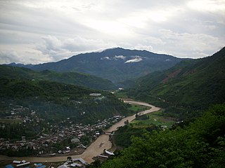
Khongsang railway station is a railway station in Tamenglong district, Manipur about 106 km from capital Imphal by road. Its code is KGBP. It serves Khongsang village of Nungba sub-division of Tamenglong District. The station includes two platforms. The first train engine reached Khongsang station on March 14, 2022. The first Goods Train reached Khongsang station on March 28, 2022. On October 13, 2022, the President of India flagged off the first passenger train from Agartala to Khaongsang. Presently two trains terminate and originate from Khongsang Railway Station, 12097/12098 Agartala Khongsang Jan Shatabdi Express and 05659/05660 Silchar Khongsang Passenger Special.
Pongringlong (Charoipandongba), also known locally as Puangringluang, is a Rongmei Naga village located along NH 37. The village is located within the Saitu Gamphazol subdivision of Senapati district, Manipur state, India. The villagers are mostly small farmers practicing Slash-and-burn, or jhum, cultivation of land that is communally owned.

Imphal Valley or Manipur Valley is located in the Indian state of Manipur and is an irregular almost oval shaped canyon that was formed as a result of the multiple small rivers that originate from neighbouring hill regions surrounding the valley and flow through it. The water in the Imphal valley is fetched from several rivers that flows via the valley, such as Imphal River, Iril River, Thoubal River, Khuga River and Sekmai river.


