The United States Post Office Department was the predecessor of the United States Postal Service, in the form of a Cabinet department officially from 1872 to 1971. It was headed by the Postmaster General.

A postal code is a series of letters or digits or both, sometimes including spaces or punctuation, included in a postal address for the purpose of sorting mail.
A ZIP Code is a postal code used by the United States Postal Service (USPS) in a system it introduced in 1963. The term ZIP is an acronym for Zone Improvement Plan; it was chosen to suggest that the mail travels more efficiently and quickly when senders use the code in the postal address. The basic format consists of five digits. An extended ZIP+4 code was introduced in 1983 which includes the five digits of the ZIP Code, followed by a hyphen and four additional digits that reference a more specific location.
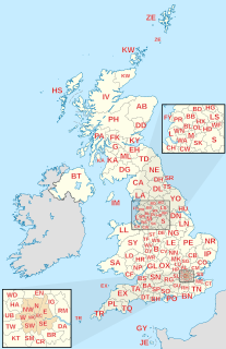
Postal codes used in the United Kingdom are known as postcodes. They are alphanumeric and were adopted nationally between 11 October 1959 and 1974, having been devised by the General Post Office. A full postcode is known as a "postcode unit" and designates an area with a number of addresses or a single major delivery point.
A Canadian postal code is a six-character string that forms part of a postal address in Canada. Like British, Irish and Dutch postcodes, Canada's postal codes are alphanumeric. They are in the format A1A 1A1, where A is a letter and 1 is a digit, with a space separating the third and fourth characters. As of September 2014, there were 855,815 postal codes using Forward Sortation Areas from A0A in Newfoundland to Y1A in the Yukon.
A Postal Index Number (PIN), or sometimes redundantly PIN code, is a code in the post office numbering or postal code system used by India Post, the Indian postal entity. The code is six digits long.
Events in the year 1972 in the Republic of India.
The INSEE code is a numerical indexing code used by the French National Institute for Statistics and Economic Studies (INSEE) to identify various entities, including communes, départements. They are also used as national identification numbers given to people.
An address is a collection of information, presented in a mostly fixed format, used to give the location of a building, apartment, or other structure or a plot of land, generally using political boundaries and street names as references, along with other identifiers such as house or apartment numbers. Some addresses also contain special codes, such as a postal code, to make identification easier and aid in the routing of mail.

The Department of Posts (DoP), trading as India Post, is a government-operated postal system in India under the Department of Posts, which is part of the Ministry of Communications of the Government of India. Generally called "the post office" in India, it is the most widely distributed postal system in the world.

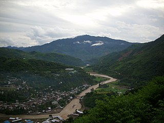
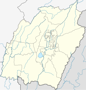
Tamenglong district (Pron:/tæmɛŋˈlɒŋ/) is one of the districts of Manipur state in northeastern India.

Postcodes are used in Australia to more efficiently sort and route mail within the Australian postal system. Postcodes in Australia have four digits and are placed at the end of the Australian address. Postcodes were introduced in Australia in 1967 by the Postmaster-General's Department and are now managed by Australia Post, and are published in booklets available from post offices or online from the Australia Post website.
Outer Manipur Lok Sabha constituency is one of the two Lok Sabha (parliamentary) constituencies in Manipur, a state in northeastern India. The seat is reserved for scheduled tribes.
Nungba is a small town surrounded by a low-lying hill ranges and rivers, an extension of eastern Indian Himalayas. The highest point of Nungba "Ramphaan But" which means "Viewpoint" stands high at the centre of the town.
Gaikhangam Gangmei is an Indian Politician and former Deputy Chief Minister of Manipur, India. He belongs to the Rongmei tribe. Born and brought up from Gaidimjang Khoupum valley.

Allowal is a medium size village in Phillaur tehsil of Jalandhar District of Punjab State, India. It is located 5 km away from postal head office Phillaur, 14.8 km from Goraya, 48 km from Jalandhar and 111 km from state capital Chandigarh. The village is administrated by a sarpanch who is an elected representative of village as per Panchayati raj (India).
Ramgarh is a medium size village in Phillaur tehsil of Jalandhar District of Punjab State, India. It is located 1 km away from postal head office Phillaur, 16 km from Ludhiana, 45 km from district headquarter Jalandhar and 118 km from state capital Chandigarh. The village is administrated by a sarpanch who is an elected representative of village as per Panchayati raj (India).
Bakapur is a village in Phillaur tehsil of Jalandhar district of Punjab State, India. It is located 7 km away from postal head office in Phillaur, 10 km from Goraya, 41.5 km from district headquarter Jalandhar and 115 km from state capital Chandigarh. The village is administrated by a sarpanch who is an elected representative of village as per Panchayati raj (India).