Bodoland Territorial Region

Last updated

Bodoland Territorial Region
Motto(s): 
Satyameva Jayate
("Truth alone triumphs")
Slogan(s): For Peace and Development
Bodoland Territorial Area Districts.svg
Bodoland Territorial Region Within India
Coordinates: 26°42′N91°05′E / 26.700°N 91.083°E / 26.700; 91.083
CountryFlag of India.svg  India
State Assam
EstablishedFebruary 9, 2003;21 years ago (2003-02-09)
Capital Kokrajhar
Districts 4
Government
  Type Autonomous Administrative Region
  Body Bodoland Territorial Council
   Chief Executive Pramod Boro [1] [2]
  Deputy Chief ExecutiveGobinda Basumatary [3]
  SpeakerKatiram Boro
Area
  Total8,970 km2 (3,460 sq mi)
Population
 (2011)
  Total3,155,359
  Density350/km2 (910/sq mi)
Languages [4]
  Official Bodo, Assamese, English [5]
Time zone UTC+05:30 (IST)
Website bodoland.gov.in

The Bodoland Territorial Region (BTR) is an autonomous division in Assam, India, and a proposed state in Northeast India. It is made up of four districts on the north bank of the Brahmaputra river below the foothills of Bhutan and Arunachal Pradesh. It is administered by an elected body known as the Bodoland Territorial Council which came into existence under the terms of a peace agreement signed in February 2003 and its autonomy was further extended by an agreement signed in January 2020. The region covers an area of over nine thousand square kilometres and is predominantly inhabited by the Bodo people and other indigenous communities of Assam. [6] [7]

Contents

Etymology of Bodoland

The Plains Tribes Council of Assam had demanded, since its inception in 1967, for a separate union territory for the Boro and other plain tribes to be called Udayachal. [8] With the failure of PTCA, the All Bodo Students' Union launched the Bodo Movement in 1987 with the demand for a separate state to be called Bodoland, [9] ending with the Bodo Accord of 1993 with the formation of Bodoland Autonomous Council. [10] Bodoland is named after Bodo, an alternative spelling of the Boro people who live primarily in the Dooars regions of Goalpara and Kamrup districts.

History

Map of the Languages and Dialects of the Bara or Bodo Group of the Tibeto-Burman Family (cropped).jpg
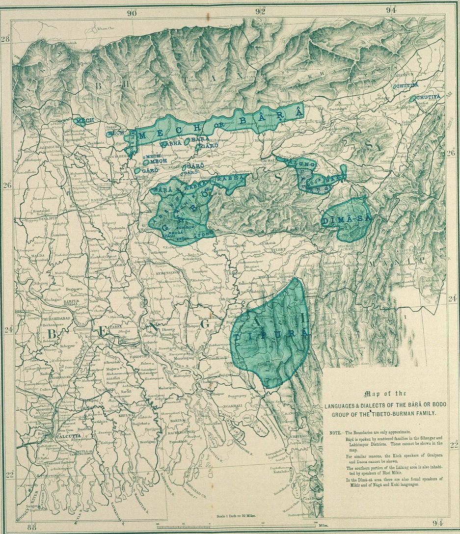
Bodoland is Mech or Bârâ region of North bank, as reported in the Language Survey of India 1903
A Brahma Temple at Kokrajhar Album Pose.jpg
A Brahma Temple at Kokrajhar

Originally a part of ancient Kamarupa this region came under the control of Koch king Vishwa Singha in the early 16th century. [11] Around 1562, the successor king Nara Narayan determined that the Meches and Koches peoples north of the newly constructed Gohain Kamal Ali could follow their indigenous customs whereas peoples to its south had to follow Hindu Brahmanical rites. [12] [13] After the split of the Koch kingdom and subsequent collapse of the eastern Koch Hajo due to the Mughals and during the period of Ahom-Mughal conflicts in early 17th century the Bhutan kingdom pushed south and took control of the region down to the Gohain Kamal Ali. [14] [15] Following the Battle of Itakhuli in 1681 the Ahom kingdom consolidated their rule up to the Manas river in the west and the region north of the Gohain Kamal Ali, divided into different Duars , fell into its possession. [16] The Ahoms soon faced trouble from the Bhutanese, in the form of incursions, raids, [17] and violent opposition, beginning about 1688, to tax collection by the Ahoms. [18] Eventually these clashes came to an end with a written agreement. [18]

Duars between Sankosh river and Manas river were collectively known as the Eastern Duars, those between Manas river and Barnadi river were collectively known as Kamrup Duars, [19] and those between Barnadi river and Dhansiri river were collectively known as Darrang Duars. [20] [21] The duars to the west of Goalpara were called Western Duars.

The Duars in the Goalpara region (which was outside the Ahom kingdom) were under Bhutan's control, but the administration of the Duars to east were shared between Bhutan or Tibet and the Ahom kingdom under different mechanisms. [22] [23] The Duars in the Kamrup region followed the posa system in which the Bhutanese were given possession of the duars in lieu of an annual payment; [24] and those in the Darrang region were alternately controlled by the Bhutanese and the Ahoms in an annual cycle. [25] The Bhutanese control over these regions were via local authorities, not ethnic Bhutanese, who were appointed by Bhutanese provincial governors called Ponlops [26]

After the British took control of Ahom kingdom in 1826, they maintained the Ahom-Bhutan arrangement for a while but the payments made in kind and the shared administration were something the colonial administration was unwilling to maintain [27] and annexed the Kamrup and Darrang Duars in 1841 and the Kariapar Duar in 1844; [28] and following the Duar War in 1865 took complete possession of the Duars and removed Bhutanese interest from the Goalpara and Western Duars for good. The duars associated with the historical regions of Goalpara, Kamrup, and Darrang were then added to these districts.

Demand for statehood

Along with the other parts of Northeast India, regional aspiration in the region reached a turning point in the 1980s. The isolation of the region, its complex social character, and its backwardness compared to other parts of the country have all resulted in the complicated set of demands ranging from demand for autonomy and opposition to migrants to movements for secession.

The region is also the gateway to the North Eastern Region of India, where one of the main students organization, All Bodo Students Union (ABSU), allied with National Democratic Front of Boroland – Progressive (NDFB-P), National Democratic Front of Boroland – D.R. Nabla faction, People's Joint Action Committee for Boroland Movement (PJACBM) which is an amalgamation of over three dozen Bodo organisations [29] and its supporters are demanding from the Government of India that a separate state (within the Indian Union) be created comprising the seven districts of Kokrajhar, Chirang, Baksa, Udalguri, Sonitpur, Lakhimpur and Dhemaji of Assam which have a significant Bodo population. [30] [31] On the other hand, it is also claimed as a sovereign state (complete independence from India) by the separatist insurgent group NDFB. [32]

1993 and 2003 peace agreements

Following an agreement in 1993, Bodoland became an autonomous administrative unit constituted under the Sixth Schedule area of the Constitution of India covering an area of 8,795 km2 administered by the Bodoland Autonomous Council.

Following a further peace agreement, the Bodoland Territorial Council was formed in 2003, with a mission to accomplish development in the area of economic, education, preservation of land right, linguistic aspiration, socio-culture and ethnic identity of Bodos and above all to speed up the infrastructure development of communities in the Bodoland area. The actual functioning of the council was started on 7 December 2003 by constituting the 12 members of the Council provisionally.

After the Council Election on 13 May 2005 and subsequent bye-election in November 2005, the 40-member Legislative Council has been formed to look after the development works in the Bodoland Territorial Area Districts. The remaining six members are nominated by the Governor of Assam from the unrepresented Communities. Thus there are altogether 46 members of the council, representing all communities of BTC Area known as Member of Council Legislative Assembly (MCLA).

2020 peace agreement and the formation of the Bodoland Territorial Region

A new peace agreement was signed on 27 January 2020 between the Government of India and the Government of Assam on one side and the National Democratic Front of Bodoland (NDFB), the All Bodo Students’ Union and United Bodo People's Organisation on the other. [33] Under the terms of this agreement, a Bodoland Territorial Region was formed with enhanced executive and legislative powers. The Bodoland Territorial Council will have competency over almost all areas defined by the Sixth Schedule of the Constitution of India and its membership will be increased to 60. [34] The boundary of BTR will be redrawn to make Boro speakers majority within the region. This will be done by forming new districts and the boundary of the region will be adjusted to include contiguous Bodo inhabited areas from neighbouring districts and exclude the non-Bodo inhabited territories which are currently under the jurisdiction of the BTC. [35] [36] [37] On 26 January 2023, Assam Chief Minister Himanta Biswa Sarma have decided to include 60 more villages which have at least 80% Bodo population in the Bodoland Territorial Region, in order to make Bodo-speakers a slight majority. [38] [39] [40]

Bodoland will also have the right to autonomously be represented at national level sports and cultural events such as the National Games of India and the Khelo India Youth Games. [41] The agreement also makes the Bodo language with Devnagri script an associate official language of Assam.

Government and politics

Bodoland Territorial Council

The region is administered by an elected body known as the Bodoland Territorial Council (BTC) which was established according to the Memorandum of Settlement of 10 February 2003. BTC came into existence immediately after the surrender of Bodo Liberation Tigers Force (BLTF). The BLTF laid down their weapons on 6 December 2003 under the leadership of Hagrama Mohilary and Shri Hagrama Mohilary was sworn in as the Chief Executive Member (CEM) on 7 December 2003.

The BTC has 46 members (30 seats reserved for scheduled Tribes, 5 seats for non-scheduled tribes and 5 open seats) and 6 seats of which are nominated by Governor of Assam from unrepresented communities. The council appoints a cabinet of 14 executive members each looking after a specific area of control.

Districts

The Bodoland region is made up of five districts which are further subdivided into 10 Civil Subdivisions and 40 Development Blocks. [42]

The area and population of these districts has been estimated as follows:

NoNameArea (km2)Population (census 2011)
1 Kokrajhar 3,169887,142
2 Chirang 1,974482,162
3 Baksa 1,573560,925
4 Udalguri 2,012831,668
5 Tamulpur 884389,150
Total9,6123,151,047

Under the terms of a peace agreement signed in January 2020, new districts will be created with the existing four districts reorganised into seven districts. The area of the region will be enlarged and will also include two new districts created from areas currently outside the region. The total number of districts within the Bodoland region will therefore be nine. [43] In January 2022, Tamulpur district was created by separating the Tamulpur sub-division from Baksa district. [44]

The proposed new districts created from districts currently within the Bodoland region are
The proposed new districts created from districts currently outside the Bodoland region are

Geography

The geographical boundary of the BTR lies between 26° 7'12'' N to 26° 47' 50'' N Latitude and 89° 47' 40'' E to 92° 18' 30'' E Longitude and is in the North Western part of Assam. Kokrajhar town the Administrative Head Quarter lies roughly between 26° 25' N latitude and 90° 16' 38'' E Longitude.

Its strategic location is blessed with beautiful forests full of flora and fauna. [42]

Economy

Agriculture in Kokrajhar district A collage of vegetables spices puthimari growing in Kokrajhar.jpg
Agriculture in Kokrajhar district

The economy is largely agricultural based and is lagging behind in urbanization and development. The region is industrially backward with most of its population depending on agriculture for livelihood. Most of the industries like oil, gas and major industries of the state are located in upper Assam.

Tourism

Tourism in the region is regulated by the department of Bodoland Tourism. Manas National Park is the major tourist attraction of the region. It also has many wildlife sanctuaries, reserve forests, site seeings, picnic spots, and events. [45]

Manas National Park

Main entrance of Manas National Park in Chirang Manas National Park.jpg
Main entrance of Manas National Park in Chirang

Manas, the nature's abode is at the foothills of Bhutan with its unique biodiversity and landscape. The blending of the dense jungle and grassland at the confluence of Indian, Ethiopian and Indo Chinese realms enhances it as one of the richest region of wild animals. The Park harbours 60 species of mammals of which 23 has been listed in Schedule 1 under the Indian Wildlife Protection Act 1972. The Park also has a recorded count of 36 species of reptiles and 476 species of birds. The Park is home for Elephant, Rhino, Tiger, Gaur, Wild Buffalo, Deer, Wild Hogs, and many other Reptiles, Birds and Insects including some highly endangered species like Pygmy Hog, Golden Langur & Bengal Florican. It is not only a significant National Park of India but also an important migratory corridor for the elephant population of the entire Indo-Bhutan region. Manas is also included in the much ambitious plan nomenclature as Indian Rhino Vision −2020 (IRV-2020) since 2006, with the support of Govt. of Assam in collaboration with Wildlife Trust of India, (WTI), Bodoland Territorial Council, WWF-India, International Rhino Foundation, and US Fish and Wildlife Service.

Gethsemane Man-made Forest

Situated in Udalguri's Bhairabkunda, it is a forest-grown entirely by local JFMC of 35 members with the help of Forest department of Assam. [46] Spread across more than 6 km2, the forest contains more than 1.4 million plus trees of over 35 varieties. A number of animals, birds and reptiles [47] can also be spotted in the area. Visitors can trek through the trail in the forest and stay the night in their guest house. [48]

Trekking of Baukungri Hill

Baukungri hill trekking is an adventurous event held annually in Kokrajhar, Bodoland. It is organised every year on first day of the year according to the Bodo calendar which falls in mid April. [49]

Demographics

Religions in Bodoland (2011) [50] [51] [52]

   Hinduism (71.25%)
   Islam (19.25%)
   Christianity (9.25%)
  Others (0.25%)
Language in Bodoland (2011 Census) [53]
LanguagePercent
Bodo
30.4%
Assamese
25.5%
Bengali
20.4%
Santali
5.3%
Nepali
3.3%
Rajbongshi
3.1%
Kurukh
1.4%
Hindi
1.2%
"Others" under Assamese
1.1%
Rabha
1%
Others
7.3%

Population

Bodos constitute the largest ethnic Tribe in the region numbering around 1.2 million (31.5%) followed by Bangla-speaking Miya people, who form the largest minority group as per 2011 Census. [54] The population of BTC area as per 2011 Census report is 3.2 million out which the ST[ clarification needed ] population is around 38% of which only 3% of the total population live in urban areas. The average density of the population in BTC is 326 per Sq.K.m. compared to 340 per Sq.K.m. of Assam. Amongst the ST/SC population Bodos, and others Indigenous Assamese tribe like Rabha, Sarania-Kachari, Modahi-Kachari and less quantity of Assamese speaking SC caste Kaibarta, Hira, Bania are inhabiting in this area out of which Bodos are dominant. [54] The other ethnic groups like Kamatapuri speaking Koch-Rajbanshi, Nath-Jogi, Kalita, Sutradhar are inhabiting in large part of BTC. Adivasi communities including Santhal, Oraon etc. are also available in sizeable numbers. Moreover, other general communities like ethnic Assamese Muslim like Garia, Maria and Deshi(Uzani) and large number of Bengali speaking Miya Muslim and Bengali Hindu people, Gorkha and few numbers of Hindi speaking people are also found in the Council area. [55]

Culture

A green coloured Aronai with white Agor (design) Aronai.jpg
A green coloured Aronai with white Agor (design)
Bodo girls dancing the Bagurumba dance Bodo dance.jpg
Bodo girls dancing the Bagurumba dance

The Bodos have a distinct culture from the rest of the world, ranging from dance and music to festivals and attires.

Sports

Football is popular in the region with clubs like Bodoland FC, competing in Durand Cup; [56] and United Chirang Duar FC playing in the fourth tier of Indian football, I-League 3. [57] Many clubs from the region also participate in the state football league.

See also

Related Research Articles

<span class="mw-page-title-main">Boro people</span> Ethnolinguistic group in northeast India

Boro, also called Bodo, is an ethnolinguistic group native to the state of Assam in India. They are a part of the greater Bodo-Kachari family of ethnolinguistic groups and are spread across northeastern India. They are concentrated mainly in the Bodoland Territorial Region of Assam, though Boros inhabit all other districts of Assam and Meghalaya.

<span class="mw-page-title-main">Bongaigaon district</span> District of Assam in India

Bongaigaon district (Prpn:ˈbɒŋgaɪˌgãʊ) is an administrative district in the state of Assam in northeastern India. The district headquarters are located at Bongaigaon. The district occupies an area of 1,093 km2.

<span class="mw-page-title-main">Darrang district</span> District of Assam in India

Darrang is an administrative district in the state of Assam in India. The district headquarters are located at Mangaldoi. The district occupies an area of 1585 km2.

<span class="mw-page-title-main">Kokrajhar district</span> Administrative district of Assam, India

Kokrajhar district is an administrative district in Bodoland Territorial Region of Assam. It is predominantly inhabited by the Boro tribe. The district has its headquarters located at Kokrajhar Town and occupies an area of 3,169.22 km2 (1,223.64 sq mi). It has two civil sub-divisions namely Parbatjhora and Gossaigaon and five revenue circles namely Kokrajhar, Dotma, Bhaoraguri, Gossaigaon and Bagribarilll

<span class="mw-page-title-main">Dooars</span> Alluvial floodplains in eastern-northeastern India

The Dooars or Duars are the alluvial floodplains in eastern-northeastern India and southern Bhutan that lie south of the outer foothills of the Himalayas and north of the Brahmaputra River basin. This region is about 30 km (19 mi) wide and stretches over about 350 km (220 mi) from the Teesta River in West Bengal to the Dhansiri River in Udalguri district of Assam. The region forms the gateway to Bhutan. It is part of the Terai-Duar savanna and grasslands ecoregion.

Kokrajhar is a town in the Bodoland Territorial Region, an autonomous territory in Assam, one of the North Eastern states of India.

<span class="mw-page-title-main">Bodo Liberation Tigers Force</span> Dissolved armed militant group in Assam, India

The Bodo Liberation Tigers Force, also known as the Bodo Liberation Tigers, was an armed militant group that operated in the Bodo dominated regions of Assam, India. The BLTF was founded on 18 June 1996 by Prem Singh Brahma and Hagrama Mohilary. Hagrama Mohilary was the chief of the outfit.

<span class="mw-page-title-main">Chirang district</span> District of Assam in India

Chirang District is an administrative district in the Bodoland Territorial Region of Assam state in the North-East of India.

<span class="mw-page-title-main">Bodoland Territorial Council</span> Territorial council in Assam state, India

The Bodoland Territorial Council (BTC) is an autonomous council for the Bodoland Territorial Region established under 6th Schedule of The Constitution of India according to the Memorandum of Settlement between Bodoland Liberation Tiger Force (BLTF) and Government of India and Government of Assam.

<span class="mw-page-title-main">Hagrama Mohilary</span> Indian politician

Hagrama Mohilary is an Indian politician who has served as the first Chief Executive Member of the Bodoland Territorial Council from 2005 to 2020, representing the Deborgaon constituency. He is the chairperson of the Bodoland People's Front and had been the head of Bodoland Territorial Council since its inception in 2003. He won the third General Assembly Elections 2015 and formed his Government for the third time. Mohilary was the chief of the Bodo Liberation Tigers (BLT) before joining the mainstream politics in 2003.

<span class="mw-page-title-main">Baksa district</span> District of Assam in India

Baksa district is an administrative district in the Bodoland Territorial Region of Assam, one of the North-Eastern states of India. The administrative headquarters is at Mushalpur. Manas National Park is a part of this district.

<span class="mw-page-title-main">Udalguri district</span> District of Assam in India

Udalguri district (Pron:ˌʊdʌlˈgʊəri), also known as Odalguri, is a district in the Bodoland Territorial Region of the state of Assam in Northeastern India. Udalguri town is the headquarters of the district.

<span class="mw-page-title-main">Upper Assam division</span> Division in Assam, India

Upper Assam is an administrative division of the state of Assam comprising the undivided Lakhimpur and Sivasagar districts, of the upper reaches of the Brahmaputra valley. The other divisions are: Lower Assam, North Assam and Hills and Barak Valley. The division is under the jurisdiction of a Commissioner, stationed at Jorhat.

Goalpara region, largely congruous to the historical undivided Goalpara district, is a region that is associated with the people and culture of Goalpara. It is bounded on the north by Bhutan, on the east by the Kamrup region, in the south by Meghalaya and in the west by Cooch Behar and Jalpaiguri in West Bengal and Rangpur in Bangladesh. The natural landmarks are: Sankosh and Brahmaputra rivers on the west, the Manas river on the east in the north bank, and a corresponding region in the south bank; the Garo Hills in the south and Bhutan Hills in the north.

<span class="mw-page-title-main">Undivided Goalpara district</span>

The Undivided Goalpara district is an erstwhile district of Assam, India, first constituted by the British rulers of Colonial Assam.

<span class="mw-page-title-main">British annexation of Assam</span>

The present-day state of Assam and its predecessor Undivided Assam was colonized by the East India Company and the British Raj over a period of 150 years—beginning with the Goalpara region in 1765 to drawing of the McMahon Line in 1913-1914 when the British consolidated its rule over the present-day Arunachal Pradesh.

<span class="mw-page-title-main">Lower Assam division</span> Division in Assam, India

Lower Assam division is one of the 5 administrative divisions of Assam in India. It was formed in 1874, consisting of the undivided Kamrup district of Western Assam, undivided Darrang and Nagaon districts of Central Assam and Khasi & Jaintia hills of Meghalaya, created for revenue purposes. The division is under the jurisdiction of a Commissioner, who is stationed at Guwahati. The division currently covers the Western Brahmaputa Valley. Shri Jayant Narlikar, IAS is the current Commissioner of Lower Assam division.

Assam – 16th largest, 15th most populous and 26th most literate state of the 28 states of the democratic Republic of India. Assam is at 14th position in life expectancy and 8th in female-to-male sex ratio. Assam is the 21st most media exposed states in India. The Economy of Assam is largely agriculture based with 69% of the population engaged in it. Growth rate of Assam's income has not kept pace with that of India's during the Post-British Era; differences increased rapidly since the 1970s. While the Indian economy grew at 6 percent per annum over the period of 1981 to 2000, the same of Assam's grew only by 3.3 percent.

<span class="mw-page-title-main">Gohain Kamal Ali</span>

Gohain Kamal Ali was an embanked road that connected the capital of the Koch dynasty, Cooch Behar in North Bengal to heart of Agomani in Dhubri and Narayanpur in Lakhimpur district in Assam, and ran along the foot of the Bhutan hills and the Dafla (Nishi) hills. This was constructed under the supervision of Gohain Kamal, the step-brother of the king, Nara Narayan and was completed in 1547. This was the road that the Koch general Chilarai used soon after for his invasion of the Ahom kingdom, and attacked the Ahom fort at Pichala, which was not a success, but a later movement in 1562 was greatly successful.

<span class="mw-page-title-main">Pramod Boro</span> Indian politician

Pramod Boro is an Indian politician serving as the president of the United People's Party Liberal (UPPL) since 2020 and the 2nd and current Chief Executive Member of the Bodoland Territorial Council since 2020 representing Koklabari. He was the former president of All Bodo Students Union from 2009 to 2015.

References

  1. Das, Mukut (14 December 2020). "From student leader to BTC chief: The meteoric rise of Pramod Boro". The Times of India. Retrieved 15 December 2020.
  2. "BTC Elections Result: UPPL's Pramod Boro declared new BTC chief". The Sentinel. 13 December 2020. Retrieved 20 February 2021.
  3. "Bodoland Territorial Council: Five members of BJP-UPPL-GSP coalition sworn in". Deccan Herald. 15 December 2020. Retrieved 15 December 2020.
  4. "Assam govt to bring ordinance to accord Bodo as associate official language". The New Indian Express. 7 October 2020. Retrieved 4 December 2020.
  5. "As Assam grants Bodo language official status, here's all you need to know on Bodoland struggle". ThePrint. 8 October 2020. Retrieved 27 February 2022.
  6. "Bodoland Territorial Council (BTC) Accord". cdpsindia.org. Archived from the original on 19 April 2012. Retrieved 15 December 2011.
  7. "THE BODOLAND AUTONOMOUS COUNCIL ACT, 1993" (PDF). ucdpged.uu.se. Retrieved 3 December 2020.
  8. "(T)he Bodo leadership in 1967 formed a political party called the Plains Tribals Council of Assam (PTCA). Since its formation, the PTCA has categorically demanded a union territory for the Bodosand other Plains tribals of the region called Udayachal." ( George 1994 :879)
  9. "ABSU took over the leadership of the Bodos; it launched a movement for greater autonomy on March 2, 1987, with the demand for creation of a full fledged state of Bodoland outside of Assam." ( George 1994 :880)
  10. "These efforts ultimately resulted in the Bodo Accord, signed at Guwahati on February 20, formally ending the six-year Bodoland agitation...The Bodo Accord provides for a Bodoland Autonomous Council (BAC)..." ( George 1994 :887)
  11. "When Biswa Singha (1515-40) rose to power, the local chiefs, who ruled the country between the river Sonkosh and the Baradi were subdued and the Koch occupied the Duar areas." ( Das 1998 :29)
  12. "[Nara Narayana] further instructed the Meches and Koches living to the north of the Gosain Kamal Ali to follow their tribal customs, but in the territory south of this road as far as the Brahmaputra Brahmanic rites were to be continued." ( Nath 1989 :55)
  13. Naranarayan placed an image of Goddess Durga and appointed a Kachari as its priest. He then collected all the Bhutias of Duars, the Kacharis and Meches living between the Bhutan hills and the Gohain Kamal Ali and ordered that the former could follow their tribal custom in the territory upto the Gohain Kamal Ali.( Das 1998 :31–32)
  14. "Taking advantage of [the collapse of Koch Hajo], the Bhutias pushed their southern boundary towards the plains and occupied the land upto the Gohain Kamal Ali." ( Das 1998 :13)
  15. "During the period of political uncertainty caused by the Ahom-Mughal conflict in the middle of seventeenth century, the Bhutias had taken possession of the whole of the fertile plain south of their hills as far as the Gohain Kamal Ali." ( Das 1998 :59)
  16. "These Duars play crucial role in the determination of the relations between Assam and Bhutan. The term ‘Duar’ literally meaning ‘door’ in English, is used to refer to the areas below the foothills is equivalent to Bhutanese ‘las-sgo’ (lit. work-door) which always carries the sense of a border mart at the foot of a pass and the area in its immediate vicinity." ( Das 1998 :26)
  17. "As a result, they are said to have harassed the population along the Assam frontiers with persistent incursions and raids."( Phuntsho 2013 :394)
  18. 1 2 ( Phukan 2014 :65)
  19. "The Kamrup duars were Bijni, Chapakhamar, Chapaguri, Baksa and Gharkola." ( Phukan 2014 :63)
  20. ( Das 1998 :26)
  21. "The two Darrang duars were Bariguma and Killing." ( Phukan 2014 :63)
  22. Das (1998 , p. 32)
  23. "While Bhutan generally enjoyed absolute possession of the eleven Bengal duars, its control over the seven Assam duars was not straightforward. Even during the Ahom rule, the Bhutanese did not gain full possession of the duar tracts. As a result, they are said to have harassed the population along the Assam frontiers with persistent incursions and raids." ( Phuntsho 2013 :394)
  24. "In order to avoid these violent attacks, the Ahom rulers gave possession of the five duar tracts along the Kamrup district to Bhutan in exchange for an annual payment. The payment included about thirty-seven tola of gold, thirty-seven bags of musk, thirty-seven yak tails, thirty-seven daggers, thirty-seven blankets, fifty-seven ponies and about 4785 Narrainee rupees in cash in total." ( Phuntsho 2013 :394)
  25. "It was also provided that the Darrang Duars were to be annually surrendered to the Ahom government for four months from Ashar to Aswin. (that is from the 15th of June to the 15th of October)." ( Das 1998 :30)
  26. ( Phuntsho 2013 :394)
  27. "This arrangement between Bhutan and Ahom rulers of control over the seven Assam duars continued with the British after their annexation of Assam in 1826." ( Phuntsho 2013 :395)
  28. Das (1998 , p. 31)
  29. "Bodo groups impose 12-hour 'bandh' in Assam over statehood demand". Hindustan Times. 11 September 2017. Retrieved 3 December 2020.
  30. "A demand for Bodoland, with blood". The Telegraph. Retrieved 3 December 2020.
  31. "Teer in Shillong: Teer Result Online | F/R & S/R » [2020]". TeerinShillong.
  32. T8N (14 September 2017). "NDFB(S) eyes Bodoland sovereignty". Archived from the original on 16 March 2018. Retrieved 27 September 2017.{{cite news}}: CS1 maint: numeric names: authors list (link)
  33. "Govt signs historic Bodo peace accord, Amit Shah says golden future awaits Assam". India Today. 27 January 2020. Retrieved 3 December 2020.
  34. "How the Bodo Accord was accomplished, establishing a wider template for peace in the Northeast". Times of India Blog. 6 February 2020. Retrieved 3 December 2020.
  35. "Assam sets up commission to redraw BTAD boundary as per Bodo accord". 25 September 2020.
  36. "Bodoland Area is set to be redrawn". The Hindu. 25 January 2020.
  37. "Assam: BTR boundary commission to submit report within August 15". February 2021.
  38. "60 more villages to get included in Bodo council, says Assam CM". 26 January 2023.
  39. "Assam to include 60 new villages in BTR".
  40. "Process to include 98 villages in Bodoland Territorial Region underway - Sentinelassam". 19 January 2023.
  41. Bharati, Ananta Ram (28 January 2020). "What is Bodo Peace Accord? Read the full text of Draft Bodo Treaty". Indus Scrolls. Retrieved 3 December 2020.
  42. 1 2 "About Bodoland". www.bodoland.in. 2 December 2018.
  43. Bharati, Ananta Ram (28 January 2020). "What is Bodo Peace Accord? Read the full text of Draft Bodo Treaty". Indus Scrolls. Retrieved 3 February 2021.
  44. "Assam Govt Forms Tamulpur As New District In State". www.sentinelassam.com. 24 January 2021. Retrieved 24 January 2022.
  45. "Bodoland Tourism". www.bodolandtourism.org. Retrieved 26 March 2017.
  46. "Afforestation changes life and landscape: How a district in Assam lost a forest, gained a future". The Indian Express. 25 December 2017. Retrieved 15 May 2020.
  47. "Man-made forest houses rare flying snake". The Assam Tribune Online. Retrieved 4 December 2020.
  48. "New tourist guest house at Bhairabkunda". Assam Times. 17 November 2014. Retrieved 4 December 2020.
  49. "Kokrajhar- Three Day Baokhungri festival Begins". Arunachal24.in. 12 April 2017. Retrieved 13 April 2017.
  50. Bodoland University http://buniv.edu.in  › contentPDF Bodoland International Knowledge Festival and Religion, 2023
  51. "Assam's religious demography data in census 2011 may come as a shocker". 3 September 2014.
  52. Singh, Bikash (17 November 2022). "Bodoland People's Front chief raises religious conversion issue in letter to PM". The Economic Times.
  53. Census data Census India
  54. 1 2 "Bodos say most Muslim settlers are illegal migrants – Assam violence: Chief reasons behind the rivalry". The Economic Times. Retrieved 3 December 2020.
  55. "Bodoland Territorial Council | Kokrajhar". bodoland.gov.in. Archived from the original on 12 February 2017. Retrieved 28 March 2017.
  56. "Bodoland FC in Durand Cup". indiansuperleague.com.
  57. "Chirang Duar in I-League 3". sentinelassam.com.

Bibliography