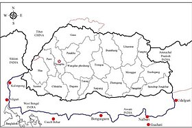
The Bodoland Territorial Region (BTR) is an autonomous division in Assam, India, and a proposed state in Northeast India. It is made up of four districts on the north bank of the Brahmaputra river below the foothills of Bhutan and Arunachal Pradesh. It is administered by an elected body known as the Bodoland Territorial Council which came into existence under the terms of a peace agreement signed in February 2003 and its autonomy was further extended by an agreement signed in January 2020. The region covers an area of over nine thousand square kilometres and is predominantly inhabited by the Bodo people and other indigenous communities of Assam.

Darrang is an administrative district in the state of Assam in India. The district headquarters are located at Mangaldoi. The district occupies an area of 1585 km2.

The Dooars or Duars are the alluvial floodplains in eastern-northeastern India and southern Bhutan that lie south of the outer foothills of the Himalayas and north of the Brahmaputra River basin. This region is about 30 km (19 mi) wide and stretches over about 350 km (220 mi) from the Teesta River in West Bengal to the Dhansiri River in Udalguri district of Assam. The region forms the gateway to Bhutan. It is part of the Terai-Duar savanna and grasslands ecoregion.

Cooch Behar, also known as Koch Bihar, was a princely state in India during the British Raj. The state was placed under the Bengal States Agency, part of the Eastern States Agency of the Bengal Presidency. It is located south of the Himalayan kingdom of Bhutan, in present-day West Bengal.
The Koch dynasty ruled parts of eastern Indian subcontinent in present-day Assam and Bengal. Biswa Singha established power in the erstwhile Kamata Kingdom which had emerged from the decaying Kamarupa Kingdom. The dynasty came to power by removing the Baro-Bhuyans, who had earlier removed the short-lived rule established by Alauddin Hussain Shah.

The Kamata Kingdom emerged in western Kamarupa probably when Sandhya, a ruler of Kamarupanagara, moved his capital west to Kamatapur sometime after 1257 CE. Since it originated in the old seat of the Kamarupa kingdom, and since it covered most of the western parts of it, the kingdom is also sometimes called as Kamarupa-Kamata.
Koch Hajo (1581–1616) was the kingdom under Raghudev and his son Parikshit Narayan of the Koch dynasty that stretched from Sankosh river in the west to the Bhareli river in the east on the north bank of the Brahmaputra river. It was created by dividing the Kamata kingdom then under Nara Narayan in medieval Assam. The Sankosh river divided the two new kingdoms, and it is roughly the boundary between the present-day Assam and West Bengal. The western half of the Kamata kingdom emerged as Koch Bihar whereas the eastern half emerged as Koch Hajo. The name Hajo comes from the legendary king Hajo, a Koch tribal chief and an ancestor of the Koch dynasty, who ruled over the Rangpur division in present-day Bangladesh and some regions of present-day Assam.

Susenghphaa or Pratap Singha, was the 17th and one of the most prominent kings of the Ahom kingdom. As he was advanced in years when he became king, he is also called the burha Raja. His reign saw an expansion of the Ahom kingdom to the west, the beginning of the Ahom-Mughal conflicts, and a reorganization of the kingdom with an expanded Paik system and reoriented village economy designed by Momai Tamuli Borbarua. His expansion to the west is underlined by the two new offices that he created: that of the Borbarua and the Borphukan. The alliances he formed with the rulers of Koch Hajo resulted in formation that successfully thwarted Mughal expansion. The administrative structure that he created survived until the end of the Ahom kingdom in 1826.

The Ahom kingdom was a late medieval kingdom in the Brahmaputra Valley that retained its independence for nearly 600 years despite encountering Mughal expansion in Northeast India. Established by Sukaphaa, a Tai prince from Mong Mao, it began as a mong in the upper reaches of the Brahmaputra based on wet rice agriculture. It expanded suddenly under Suhungmung in the 16th century and became multi-ethnic in character, casting a profound effect on the political and social life of the entire Brahmaputra valley. The kingdom became weaker with the rise of the Moamoria rebellion, and subsequently fell to repeated Burmese invasions of Assam. With the defeat of the Burmese after the First Anglo-Burmese War and the Treaty of Yandabo in 1826, control of the kingdom passed into East India Company hands.

Hajo is a historic town set in the hills northwest of Guwahati, Assam, India. It is a meeting point of Buddhists, Hindus and Muslims due to the various pilgrimage sites on the different hills of Hajo. To the Hindus, the Manikut Parbat of Hajo is the site of the 10th-century temple ruins and the 11th- to 16th-century temples complex for Vaishnavism as well as shrines of Shaivism and Shaktism. To the Buddhists, particularly from Bhutan and Tibet, Assam is where the Buddha died and the Hayagriva temple in Hajo is a part of the sacred geography of the Buddha. To the regional Muslims, the Mughal era Poa-Mecca shrine on another hill of Hajo has the tomb of Giyasuddin Aulia built in the 17th century.

Ahom–Mughal conflicts refers to the series of 17th-century conflicts between the Ahoms and the Mughals over the control of the Brahmaputra valley. It began soon after the eastern branch of the Kamata kingdom then under the Koch dynasty, Koch Hajo, collapsed after a sustained Mughal campaign bringing it face-to-face with the eastern Ahoms. After nearly seventy years of sustained efforts, the Mughals were finally ousted in the Battle of Itakhuli in 1682. The Mughals since then maintained interest to the region west of the Manas river via zamindars, till they were ousted from Bengal by the British about a hundred years later.
Biswa Singha (1515–1540) was the progenitor king of the Koch dynasty of the Kamata kingdom. He was able to unify different Bodo tribes, replace the Baro-Bhuyans of Kamata kingdom, and establish a dynasty the remnant of which still exists today.

Suklingphaa, or Kamaleswar Singha, was a king of the Ahom kingdom. He came to power when he was a toddler, and died in his teens during a small pox epidemic. The de facto ruler during his reign was Purnanada Burhagohain, who was able to consolidate power after installing him on the throne; and his parents Kadamdighala and Numali also were very powerful. Kamaleswar Singha's reign witnessed the suppression of Moamoria rebellion and restoration of Ahom rule over Upper Assam. The Dundiya Revolution in Kamrup was also suppressed during his reign. In Nagaon, the Ahom army also managed to defeat a coalition of Moamoria rebels and the Kacharis of Kachari Kingdom. Much of this was the handiwork of Purnananda Burhagohain and not Kamaleshwar Singha.
Naranarayan was the last ruler of the undivided Koch dynasty of the Kamata Kingdom. He succeeded his father, Biswa Singha. Under him the Koch kingdom reached its cultural and political zenith. Under his rule, and under the military command of his brother Chilarai, he was able to subjugate the entire Brahmaputra valley, including the Ahom kingdom; besides the Kachari, Tripura kingdoms, as well as the Khyrem, Jaintia and others. This influence was halted when he faced Suleman Karranni, the Sultan of Bengal.

Udalguri district (Pron:ˌʊdʌlˈgʊəri), also known as Odalguri, is a district in the Bodoland Territorial Region of the state of Assam in Northeastern India. Udalguri town is the headquarters of the district.

Mir Jumla II invaded the Ahom kingdom in January 1662 and left it in January–February 1663. He was able to occupy Garhgaon, the Ahom capital, before the beginning of the rainy season, but he and his army were confined mostly to Garhgaon and Madhupur during that period. The Ahom king Sutamla had to take flight and hide in Namrup during Mir Jumla's occupation of the capital. The defection of Baduli Phukan, a high ranking Ahom commander, precipitated the Treaty of Ghilajharighat in January 1663, with the Ahom king accepting tributary status. Mir Jumla died on his way back before he could reach Dhaka, his capital.

Kamrup is the modern region situated between two rivers, the Manas and the Barnadi in Western Assam, with the same territorial extent as the Colonial and post-Colonial "Undivided Kamrup district". It was the capital region of two of the three dynasties of Kamarupa and Guwahati, the current political center of Assam, is situated here. It is characterized by its cultural artifacts.
The Undivided Goalpara district is an erstwhile district of Assam, India, first constituted by the British rulers of Colonial Assam.
The Koch–Ahom relations (1532–1571) refer to the diplomatic, strategic and military relationships between the Koch and the Ahom kingdoms over the control of the Brahmaputra Valley. Though an initial contact between the Ahoms and Koch occurred during Biswa Singha's reign, the relationship became belligerent with Nara Narayana ascending to power and consolidating his hold over the western portion of Assam; and it ended with the failure of Chilarai's campaign against Sulaiman Karrani. This was followed by an alliance that soon gave way to a fierce conflict between the Ahoms and the Mughals.
Balinarayan alias Dharmanarayan or Baldeo of Mughals was the son of Koch King Raghudev and younger brother of King Parikshit and the first King of Darrang Desa. He was the chief conductor of the operations conducted against the Mughals during their occupation of Kamrupa erstwhile fallen Koch Hajo which got annexed to Mughal domain after the defeat of the latter.