Concrete is a composite material composed of aggregate bonded together with a fluid cement that cures to a solid over time. Concrete is the second-most-used substance in the world after water, and is the most widely used building material. Its usage worldwide, ton for ton, is twice that of steel, wood, plastics, and aluminium combined.

A road is a thoroughfare for the conveyance of traffic that mostly has an improved surface for use by vehicles and pedestrians. Unlike streets, whose primary function is to serve as public spaces, the main function of roads is transportation.

A tunnel is an underground or undersea passageway. It is dug through surrounding soil, earth or rock, or laid under water, and is usually completely enclosed except for the two portals common at each end, though there may be access and ventilation openings at various points along the length. A pipeline differs significantly from a tunnel, though some recent tunnels have used immersed tube construction techniques rather than traditional tunnel boring methods.

Bentonite is an absorbent swelling clay consisting mostly of montmorillonite which can either be Na-montmorillonite or Ca-montmorillonite. Na-montmorillonite has a considerably greater swelling capacity than Ca-montmorillonite.

A road surface or pavement is the durable surface material laid down on an area intended to sustain vehicular or foot traffic, such as a road or walkway. In the past, gravel road surfaces, macadam, hoggin, cobblestone and granite setts were extensively used, but these have mostly been replaced by asphalt or concrete laid on a compacted base course. Asphalt mixtures have been used in pavement construction since the beginning of the 20th century and are of two types: metalled (hard-surfaced) and unmetalled roads. Metalled roadways are made to sustain vehicular load and so are usually made on frequently used roads. Unmetalled roads, also known as gravel roads or dirt roads, are rough and can sustain less weight. Road surfaces are frequently marked to guide traffic.

Asphalt concrete is a composite material commonly used to surface roads, parking lots, airports, and the core of embankment dams. Asphalt mixtures have been used in pavement construction since the beginning of the twentieth century. It consists of mineral aggregate bound together with bitumen, laid in layers, and compacted.
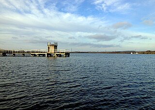
Chasewater is a reservoir located in the parish of Burntwood and the district of Lichfield in Staffordshire, England. Originally known as Norton Pool and Cannock Chase Reservoir, it was created as a canal feeder reservoir in 1797. The reservoir was created to directly supply the Wyrley and Essington Canal and maintain levels in the 160-mile (260 km) Birmingham Canal Network. During a period of great industrial growth in the Black Country region the maintenance of water levels in canal infrastructure was essential and Chasewater was in great demand. As canals became less essential for transport of goods during the mid-20th century, the reservoir diversified and became a popular public amenity with activities such as water-skiing, sailing, wakeboarding and cycling. Chasewater is the third largest reservoir by volume in the county of Staffordshire and the largest canal feeder reservoir in the West Midlands.

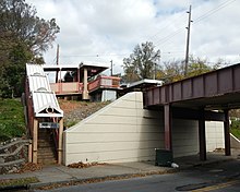
A berm is a level space, shelf, or raised barrier separating areas in a vertical way, especially partway up a long slope. It can serve as a terrace road, track, path, a fortification line, a border/separation barrier for navigation, good drainage, industry, or other purposes.

Geosynthetics are synthetic products used to stabilize terrain. They are generally polymeric products used to solve civil engineering problems. This includes eight main product categories: geotextiles, geogrids, geonets, geomembranes, geosynthetic clay liners, geofoam, geocells and geocomposites. The polymeric nature of the products makes them suitable for use in the ground where high levels of durability are required. They can also be used in exposed applications. Geosynthetics are available in a wide range of forms and materials. These products have a wide range of applications and are currently used in many civil, geotechnical, transportation, geoenvironmental, hydraulic, and private development applications including roads, airfields, railroads, embankments, retaining structures, reservoirs, canals, dams, erosion control, sediment control, landfill liners, landfill covers, mining, aquaculture and agriculture.

In earthmoving, cut and fill is the process of constructing a railway, road or canal whereby the amount of material from cuts roughly matches the amount of fill needed to make nearby embankments to minimize the amount of construction labor.

A gravel road is a type of unpaved road surfaced with gravel that has been brought to the site from a quarry or stream bed. Gravel roads are common in less-developed nations, and also in the rural areas of developed nations such as Canada and the United States. In New Zealand, and other Commonwealth countries, they may be known as metal roads. They may be referred to as "dirt roads" in common speech, but that term is used more for unimproved roads with no surface material added. If well constructed and maintained, a gravel road is an all-weather road.
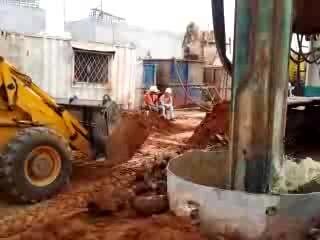
A deep foundation is a type of foundation that transfers building loads to the earth farther down from the surface than a shallow foundation does to a subsurface layer or a range of depths. A pile or piling is a vertical structural element of a deep foundation, driven or drilled deep into the ground at the building site.
In civil engineering, concrete leveling is a procedure that attempts to correct an uneven concrete surface by altering the foundation that the surface sits upon. It is a cheaper alternative to having replacement concrete poured and is commonly performed at small businesses and private homes as well as at factories, warehouses, airports and on roads, highways and other infrastructure.

An embankment dam is a large artificial dam. It is typically created by the placement and compaction of a complex semi-plastic mound of various compositions of soil or rock. It has a semi-pervious waterproof natural covering for its surface and a dense, impervious core. This makes the dam impervious to surface or seepage erosion. Such a dam is composed of fragmented independent material particles. The friction and interaction of particles binds the particles together into a stable mass rather than by the use of a cementing substance.
Landslide mitigation refers to several human-made activities on slopes with the goal of lessening the effect of landslides. Landslides can be triggered by many, sometimes concomitant causes. In addition to shallow erosion or reduction of shear strength caused by seasonal rainfall, landslides may be triggered by anthropic activities, such as adding excessive weight above the slope, digging at mid-slope or at the foot of the slope. Often, individual phenomena join to generate instability over time, which often does not allow a reconstruction of the evolution of a particular landslide. Therefore, landslide hazard mitigation measures are not generally classified according to the phenomenon that might cause a landslide. Instead, they are classified by the sort of slope stabilization method used:
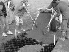
Cellular confinement systems (CCS)—also known as geocells—are widely used in construction for erosion control, soil stabilization on flat ground and steep slopes, channel protection, and structural reinforcement for load support and earth retention. Typical cellular confinement systems are geosynthetics made with ultrasonically welded high-density polyethylene (HDPE) strips or novel polymeric alloy (NPA)—and expanded on-site to form a honeycomb-like structure—and filled with sand, soil, rock, gravel or concrete.

In civil engineering, a cut or cutting is where soil or rock from a relative rise along a route is removed. The term is also used in river management to speed a waterway's flow by short-cutting a meander.
Diamond grinding is a pavement preservation technique that corrects a variety of surface imperfections on both concrete and asphalt concrete pavements. Most often utilized on concrete pavement, diamond grinding is typically performed in conjunction with other concrete pavement preservation (CPP) techniques such as road slab stabilization, full- and partial-depth repair, dowel bar retrofit, cross stitching longitudinal cracks or joints and joint and crack resealing. Diamond grinding restores rideability by removing surface irregularities caused during construction or through repeated traffic loading over time. The immediate effect of diamond grinding is a significant improvement in the smoothness of a pavement. Another important effect of diamond grinding is the considerable increase in surface macrotexture and consequent improvement in skid resistance, noise reduction and safety.
Grahamstown Dam is a major off-stream earthfill Embankment dam with a controlled labyrinth spillway and baffle chute that stores water from the Williams River. The dam is located north of Newcastle, New South Wales, Australia. The dam's main purpose is water supply; it provides about 40 per cent of the potable water for the Hunter Region; and is its largest drinking water supply dam.

Canal lining is the process of reducing seepage loss of irrigation water by adding an impermeable layer to the edges of the trench. Seepage can result in losses of 30 to 50 percent of irrigation water from canals, so adding lining can make irrigation systems more efficient. Canal linings are also used to prevent weed growth, which can spread throughout an irrigation system and reduce water flow. Lining a canal can also prevent waterlogging around low-lying areas of the canal.