Geotechnical engineering, also known as geotechnics, is the branch of civil engineering concerned with the engineering behavior of earth materials. It uses the principles of soil mechanics and rock mechanics to solve its engineering problems. It also relies on knowledge of geology, hydrology, geophysics, and other related sciences.

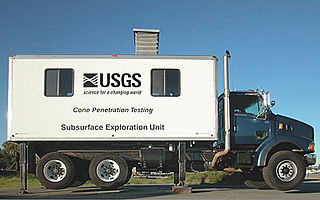
The cone penetration or cone penetrometer test (CPT) is a method used to determine the geotechnical engineering properties of soils and delineating soil stratigraphy. It was initially developed in the 1950s at the Dutch Laboratory for Soil Mechanics in Delft to investigate soft soils. Based on this history it has also been called the "Dutch cone test". Today, the CPT is one of the most used and accepted soil methods for soil investigation worldwide.

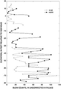
Soil liquefaction occurs when a cohesionless saturated or partially saturated soil substantially loses strength and stiffness in response to an applied stress such as shaking during an earthquake or other sudden change in stress condition, in which material that is ordinarily a solid behaves like a liquid. In soil mechanics, the term "liquefied" was first used by Allen Hazen in reference to the 1918 failure of the Calaveras Dam in California. He described the mechanism of flow liquefaction of the embankment dam as:
If the pressure of the water in the pores is great enough to carry all the load, it will have the effect of holding the particles apart and of producing a condition that is practically equivalent to that of quicksand... the initial movement of some part of the material might result in accumulating pressure, first on one point, and then on another, successively, as the early points of concentration were liquefied.

Soil mechanics is a branch of soil physics and applied mechanics that describes the behavior of soils. It differs from fluid mechanics and solid mechanics in the sense that soils consist of a heterogeneous mixture of fluids and particles but soil may also contain organic solids and other matter. Along with rock mechanics, soil mechanics provides the theoretical basis for analysis in geotechnical engineering, a subdiscipline of civil engineering, and engineering geology, a subdiscipline of geology. Soil mechanics is used to analyze the deformations of and flow of fluids within natural and man-made structures that are supported on or made of soil, or structures that are buried in soils. Example applications are building and bridge foundations, retaining walls, dams, and buried pipeline systems. Principles of soil mechanics are also used in related disciplines such as geophysical engineering, coastal engineering, agricultural engineering, and hydrology.

Rock mechanics is a theoretical and applied science of the mechanical behavior of rocks and rock masses.
The Atterberg limits are a basic measure of the critical water contents of a fine-grained soil: its shrinkage limit, plastic limit, and liquid limit.
A direct shear test is a laboratory or field test used by geotechnical engineers to measure the shear strength properties of soil or rock material, or of discontinuities in soil or rock masses.

Geotechnical investigations are performed by geotechnical engineers or engineering geologists to obtain information on the physical properties of soil earthworks and foundations for proposed structures and for repair of distress to earthworks and structures caused by subsurface conditions; this type of investigation is called a site investigation. Geotechnical investigations are also used to measure the thermal resistance of soils or backfill materials required for underground transmission lines, oil and gas pipelines, radioactive waste disposal, and solar thermal storage facilities. A geotechnical investigation will include surface exploration and subsurface exploration of a site. Sometimes, geophysical methods are used to obtain data about sites. Subsurface exploration usually involves soil sampling and laboratory tests of the soil samples retrieved.
BS 5930:2015, "the code of practice for site investigations", is a UK code of practice which came into effect on 31 July 2015 British Standards Institution.

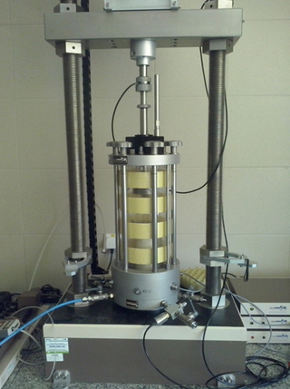
In materials science, a triaxial shear test is a common method to measure the mechanical properties of many deformable solids, especially soil and rock, and other granular materials or powders. There are several variations on the test. In a triaxial shear test, stress is applied to a sample of the material being tested in a way which results in stresses along one axis being different from the stresses in perpendicular directions. This is typically achieved by placing the sample between two parallel platens which apply stress in one direction, and applying fluid pressure to the specimen to apply stress in the perpendicular directions.

In soil science, soil gradation is a classification of a coarse-grained soil that ranks the soil based on the different particle sizes contained in the soil. Soil gradation is an important aspect of soil mechanics and geotechnical engineering because it is an indicator of other engineering properties such as compressibility, shear strength, and hydraulic conductivity. In a design, the gradation of the in situ soil often controls the design and ground water drainage of the site. A poorly graded soil will have better drainage than a well graded soil, if it is not high in clay quality.
The Proctor compaction test is a laboratory method of experimentally determining the optimal moisture content at which a given soil type will become most dense and achieve its maximum dry density. The test is named in honor of Ralph Roscoe Proctor, who in 1933 showed that the dry density of a soil for a given compactive effort depends on the amount of water the soil contains during soil compaction. His original test is most commonly referred to as the standard Proctor compaction test; his test was later updated to create the modified Proctor compaction test.
T. Leslie Youd is an American geotechnical engineer and earthquake engineer, specializing in soil liquefaction and ground failure. He currently lives in Orem, Utah.
Geoprofessions is a term coined by the Geoprofessional Business Association to connote various technical disciplines that involve engineering, earth and environmental services applied to below-ground ("subsurface"), ground-surface, and ground-surface-connected conditions, structures, or formations. The principal disciplines include, as major categories:

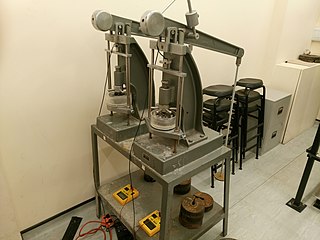
An oedometer test is a kind of geotechnical investigation performed in geotechnical engineering that measures a soil's consolidation properties. Oedometer tests are performed by applying different loads to a soil sample and measuring the deformation response. The results from these tests are used to predict how a soil in the field will deform in response to a change in effective stress.

Offshore geotechnical engineering is a sub-field of geotechnical engineering. It is concerned with foundation design, construction, maintenance and decommissioning for human-made structures in the sea. Oil platforms, artificial islands and submarine pipelines are examples of such structures. The seabed has to be able to withstand the weight of these structures and the applied loads. Geohazards must also be taken into account. The need for offshore developments stems from a gradual depletion of hydrocarbon reserves onshore or near the coastlines, as new fields are being developed at greater distances offshore and in deeper water, with a corresponding adaptation of the offshore site investigations. Today, there are more than 7,000 offshore platforms operating at a water depth up to and exceeding 2000 m. A typical field development extends over tens of square kilometers, and may comprise several fixed structures, infield flowlines with an export pipeline either to the shoreline or connected to a regional trunkline.

The Nippon Screw Weight System (NSWS) is an on-site ground survey machine that examines the geotechnical engineering properties of soil. The NSWS was developed to encounter weather abnormalities and natural hazards, saving human lives.
The jet erosion test (JET), or jet index test, is a method used in geotechnical engineering to quantify the resistance of a soil to erosion. The test can be applied in-situ after preparing a field site, or it can be applied in a laboratory on either an intact or a remolded soil sample. A quantitative measure of erodibility allows for the prediction of erosion, assisting with the design of structures such as vegetated channels, road embankments, dams, levees, and spillways.
The hole erosion test (HET) is a method used in geotechnical engineering to quantify the resistance of a soil to erosion, and is specifically relevant to the topic of internal erosion in embankment dams. The test can be performed in a laboratory on a remolded soil sample, and provides estimates of both the critical shear stress for erosion of the soil sample as well as a numerical measure of soil erodibility. In the design and engineering of embankment dams, the critical shear stress provided by this test indicates the maximum shear stress that a fluid can apply to a soil before a concentrated leak forms and erosion begins. The numerical measure of soil erodibility can be used to predict how quickly this erosion will progress, and it can be found as an input in various computer simulations for dam failure.
Izzat M. Idriss (1935-) is a Syrian-American geotechnical engineer. His research on the geotechnical aspects of earthquake engineering has led to the development of many of the currently used procedures for evaluating the behavior of soil sites and soil structures during earthquakes, such as methods for evaluating: the characteristics of earthquake ground motions; seismic response of sites; potential for soil liquefaction; performance of embankment dams during earthquakes; and soil-structure interaction in response to earthquake shaking.


