
Assam is a state in northeastern India, south of the eastern Himalayas along the Brahmaputra and Barak River valleys. Assam covers an area of 78,438 km2 (30,285 sq mi). It is the second largest state in northeastern India by area and the largest in terms of population, with more than 31 million inhabitants. The state is bordered by Bhutan and Arunachal Pradesh to the north; Nagaland and Manipur to the east; Meghalaya, Tripura, Mizoram and Bangladesh to the south; and West Bengal to the west via the Siliguri Corridor, a 22-kilometre-wide (14 mi) strip of land that connects the state to the rest of India. Assamese and Bodo are two of the official languages for the entire state and Meitei (Manipuri) is recognised as an additional official language in three districts of Barak Valley and Hojai district. in Hojai district and for the Barak valley region, alongside Bengali, which is also an official language in the Barak Valley.
Digboi is a town and a town area committee in Tinsukia district in the north-eastern part of the state of Assam, India.

Dibrugarh district (Pron:ˌdɪbru:ˈgor:) is a district in the state of Assam in India. The district headquarters are located within the city of Dibrugarh.

Lakhimpur district is an administrative district in the state of Assam in India. The district headquarter is located at North Lakhimpur. The district is bounded on the North by Siang and Papumpare districts of Arunachal Pradesh and on the East by Dhemaji District and Subansiri River. Majuli District stands on the Southern side and Biswanath District is on the West.

Tinsukia is an industrial city. It is situated 480 kilometres (298 mi) north-east of Guwahati and 84 kilometres (52 mi) away from the border with Arunachal Pradesh. Tinsukia serves as the headquarters of the Moran Autonomous Council, which is the governing council of the Morans.

Dibru-Saikhowa National Park is a national park located in Dibrugarh and Tinsukia districts, Assam, India. It was designated a Biosphere Reserve in July 1997 with an area of 765 km2 (295 sq mi), including a core area of 340 km2 (130 sq mi) and a buffer zone of 425 km2 (164 sq mi).
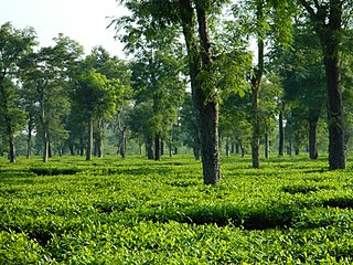
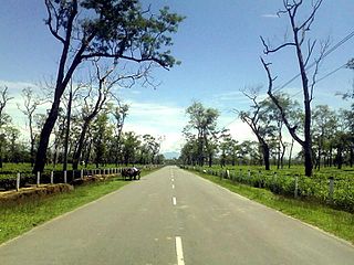
Dibrugarh is a city in Upper Assam with sprawling tea gardens. It is located 435 kms East from the state capital of Dispur. It serves as the headquarters of Dibrugarh district in the state of Assam in India. Dibrugarh serves as the headquarters of the Sonowal Kachari Autonomous Council, which is the governing council of the Sonowal Kachari tribe. The historic town of Dibrugarh was formally announced as 2nd City of Assam on 7 March 2024 with the formation of Dibrugarh Municipal Corporation by dissolving The Municipal Board
Deomali is a census town in Tirap district in the state of Arunachal Pradesh, India. The town is surrounded by hills, tea gardens, forests and rivers. It serves as the headquarters of both Deomali sub division and Namsang block. It is considered as the education hub of Tirap district and is home to Wangcha Rajkumar Government College, Deomali and renowned educational institution Ramakrishna Mission School, Narottam Nagar. Deomali also has a centre of Krishi Vigyan Kendra. The Coffee Board of India has established a Technical Evaluation Centre in Deomali, one of its such six centres in India. Additionally, Coffee Board of India maintains a 26 acres coffee plantation in Deomali. The town is 250 km from state capital Itanagar, 43 km from district headquarter Khonsa, 30 km from Margherita, 33 km from Naharkatia, 46 km from Tinsukia, 73 km from Dibrugarh and 455 km from Guwahati.

Duliajan is an industrial town of Dibrugarh district in the Indian state of Assam located in the upper north-east corner of India. The town is about 45 km east of Dibrugarh City. It is particularly known for its oil related industry, Oil India Limited, one of the country's largest oil and gas companies. There is also other central government owned companies like B.C.P.L. GDU Station, N.E.E.P.C.O., D.N.P.L., LPG Plant and the Shivani company which is India's largest private company for drilling. Assam Gas Company Limited, which carries out business related to natural gas in India owned by the Government of Assam, is also located in this township.
Sonari is a district Headquarter, mid-size town and a municipal board in newly announced Charaideo district in the Indian state of Assam.

Margherita is a census town in Tinsukia district in the Indian state of Assam. The sub-district town is surrounded by hills, tea gardens, forests and the Dihing River. It has a golf course at the foot of the hills and a small stream running through. Although considered to be a small town, Margherita has several hospitals and educational institutions and is regularly frequented by visitors on account of it being the last proper town of Upper Assam. The name Margherita actually derives from the Italian queen and dates back to the late 19th century as a token appreciation for the Italian Chief Engineer of a rail section Chevalier R Paganini who supervised the construction. Margherita was known for its collieries much developed by the British. Coal India Ltd has the biggest industrial plant here. The town is also known as Coal Queen as it is famous for coal business. Apart from this there are other industrial plants like Kitply and Tata Tea, along with minor plywood industries and tea gardens. Margherita has Tea Estates of the Williamson Magor Group. Namdang Tea Estate, Dirok Tea Estate, Dehing Tea Estate, Bogapani Tea Estate and Margherita Tea Estate are the 5 famous estates of the McLeod Russel India Limited Group situated at the sub division Margherita. McLeod Russel India Limited is one of the largest tea producers in Asia.

Assam is the main and oldest state in the North-East Region of India and as the gateway to the rest of the Seven Sister States. The land of red river and blue hills, Assam comprises three main geographical areas: the Brahmaputra Valley which stretching along the length of the Brahmaputra river, the Barak Valley extending like a tail, and the intervening Karbi Plateau and North Cachar Hills. Assam shares its border with Meghalaya, Arunachal Pradesh, Nagaland, Manipur, Tripura, Mizoram and West Bengal; and there are National Highways leading to their capital cities. It also shares international borders with Bhutan and Bangladesh and is very close to Myanmar. In ancient times Assam was known as Pragjyotisha or Pragjyotishpura, and Kamarupa.

Upper Assam is an administrative division of the state of Assam comprising the undivided Lakhimpur and Sivasagar districts, of the upper reaches of the Brahmaputra valley. The other divisions are: Lower Assam, North Assam and Hills and Barak Valley. The division is under the jurisdiction of a Commissioner, stationed at Jorhat.
Boiragimoth is a suburb of Dibrugarh city in Assam, consisting of several residential neighbourhoods and local markets. It is considered one of the most popular residential areas in the town, with shops, restaurants, schools, colleges, boarding houses, places of worship, sports facilities, and so on.
Rupai Siding is a fast developing township situated in the district of Tinsukia in Assam,(in North East) India. The place is approximately 540 km from the state capital. It was a small village about 50 years ago, which is now the Industrial Township surrounded by numerous Tea gardens and Factories and Other Allied Industries. It is said that it had one of the oldest railway tracks until few years back which was used by the Britishers to transport goods and materials. This railway track connects Dibrugarh to Dangari and runs through Rupai and hence the place is a siding and came to be known as RUPAI SIDING. Beesakopie Tea Factory, the largest tea factory in Asia is very near.

Dibrugarh railway station is a railway junction station on the Lumding–Dibrugarh section. Rated as an A Category railway station in Northeast Frontier Railway. It is located in Dibrugarh the 3rd largest city in the Indian state of Assam. Dibrugarh railway station (DBRG) is the second railway station of the historic city of Dibrugarh after Dibrugarh Town railway station (DBRT). It is the Largest railway station in Northeast India in terms of area covering approx 400 Bighas of Land. Nearest to the India's longest rail-cum-road Bogibeel Bridge which connects Southern Bank to Northern Bank of Assam.
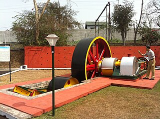
New Tinsukia is a railway junction station on the Lumding–Dibrugarh section. It is located in Tinsukia district in the Indian state of Assam. It serves Tinsukia and the surrounding areas. New Tinsukia is the second station in the town of Tinsukia after the old Tinsukia Station. The Railway Heritage Park, Tinsukia is located at the station, with locomotives from the Darjeeling Himalayan Railway (DHR), Dibru–Sadiya Railway (DSR) and Assam Bengal Railway (ABR).
Tingkhong is a town of Dibrugarh district of Assam state in northeast India. Administratively Tingkhong is located within Dibrugarh district and is today an important tea cultivation and oil exploration area of Assam. Tingkhong is approximately 80 km from Dibrugarh by road towards south-east and approximately 70 km from Tinsukia towards south. The nearest airport is Dibrugarh located at a distance of approximately 70 km and nearest small railway station is at Naharkatia town. Urban areas close to Tingkhong are Naharkatiya - 20 km, Duliajan - 33 km, Sonari - 18 km, Moran - 37 km, etc. by roadways.
Assam – 16th largest, 15th most populous and 26th most literate state of the 28 states of the democratic Republic of India. Assam is at 14th position in life expectancy and 8th in female-to-male sex ratio. Assam is the 21st most media exposed states in India. The Economy of Assam is largely agriculture based with 69% of the population engaged in it. Growth rate of Assam's income has not kept pace with that of India's during the Post-British Era; differences increased rapidly since the 1970s. While the Indian economy grew at 6 percent per annum over the period of 1981 to 2000, the same of Assam's grew only by 3.3 percent.


