North Assam Division

Last updated

North Assam Division
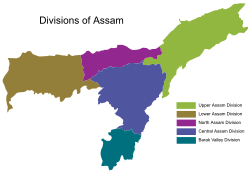
Divisions of Assam.svg
The five divisions of Assam
CountryFlag of India.svg  India
State Assam
Capital Tezpur
Largest City Tezpur
Area
  Total6,613 km2 (2,553 sq mi)
Population
 (2011 census)
  Total3 684 298

North Assam is an administrative division of Assam under the jurisdiction of a Commissioner, who is officially stationed at Tezpur. It consists of the following districts: Udalguri, Darrang, Sonitpur and Biswanath. Shri Rakesh Kumar, IAS is the current Commissioner of this division. [1]

Contents

Districts

North Assam district comprises mainly 4 districts, namely Udalguri, Darrang, Sonitpur and Biswanath.

Code [2] DistrictHeadquarterPopulation (2011) [3] Area (km2)Density (/km2)
BS Biswanath Biswanath Chariali 612 4911,100557
DR Darrang Mangaldai 928 5001,585586
ST Sonitpur Tezpur 1 311 6192,076632
UD Udalguri # Udalguri 831 6881,852449
Total43 684 2986,613557

# Districts within the Bodoland Territorial Region

Demographics

As per 2011 census, North Assam division has a population of 3,684,298

Languages

Languages spoken in North Assam Division (2011) [4]

   Assamese (36.36%)
   Bengali (25.07%)
   Boro (10.57%)
   Sadri (8.54%)
   Nepali (4.98%)
   Hindi (3.42%)
  Others (11.06%)

According to 2011 census, the total number of Assamese speakers in the division were 1,339,782, Bengali speakers were 923,791, Boro speakers were 389,390, Sadri speakers were 314,665, Nepali speakers were 183,601 and Hindi speakers were 125,908.

See also

Related Research Articles

<span class="mw-page-title-main">Bodoland Territorial Region</span> Autonomous Administrative Region in Assam, India

The Bodoland Territorial Region (BTR) is an autonomous division in Assam, India, and a proposed state in Northeast India. It is made up of five districts on the north bank of the Brahmaputra River below the foothills of Bhutan and Arunachal Pradesh. It is administered by an elected body known as the Bodoland Territorial Council which came into existence under the terms of a peace agreement signed in February 2003 and its autonomy was further extended by an agreement signed in January 2020. The region covers an area of over nine thousand square kilometres and is predominantly inhabited by the Bodo people and other indigenous communities of Assam.

<span class="mw-page-title-main">Darrang district</span> District of Assam in India

Darrang is an administrative district in the state of Assam in India. The district headquarters are located at Mangaldoi. The district occupies an area of 1585 km2.

<span class="mw-page-title-main">Lakhimpur district</span> District of Assam in India

Lakhimpur district is an administrative district in the state of Assam in India. The district headquarter is located at North Lakhimpur. The district is bounded on the North by Siang and Papumpare districts of Arunachal Pradesh and on the East by Dhemaji District and Subansiri River. Majuli District stands on the Southern side and Biswanath District is on the West.

<span class="mw-page-title-main">Sonitpur district</span> District of Assam in India

Sonitpur district [Pron: ˌsə(ʊ)nɪtˈpʊə or ˌʃə(ʊ)nɪtˈpʊə] is an administrative district in the state of Assam in India. The district headquarters is located at Tezpur.

<span class="mw-page-title-main">Dooars</span> Alluvial floodplains in eastern-northeastern India

The Dooars or Duars are the alluvial floodplains in eastern-northeastern India and southern Bhutan that lie south of the outer foothills of the Himalayas and north of the Brahmaputra River basin. This region is about 30 km (19 mi) wide and stretches over about 350 km (220 mi) from the Teesta River in West Bengal to the Dhansiri River in Udalguri district of Assam. The region forms the gateway to Bhutan. It is part of the Terai-Duar savanna and grasslands ecoregion.

<span class="mw-page-title-main">Baksa district</span> District of Assam in India

Baksa district is an administrative district in the Bodoland Territorial Region of Assam, one of the North-Eastern states of India. The administrative headquarters is at Mushalpur. Manas National Park is a part of this district.

<span class="mw-page-title-main">Udalguri district</span> District of Assam in India

Udalguri district (Pron:ˌʊdʌlˈgʊəri), also known as Odalguri, is a district in the Bodoland Territorial Region of the state of Assam in Northeastern India. Udalguri town is the headquarters of the district.

<span class="mw-page-title-main">Karbi language</span> South Asian language

The Karbi language is a Tibeto-Burman language spoken by the Karbi people of Northeastern India.

<span class="mw-page-title-main">Kalaigaon</span> Legislative Assembly Constituency in Assam, India

Kalaigaon is a town and Legislative Assembly Constituency in north-eastern India. It is situated in the Udalguri district of Assam state. The average altitude is 37 meters. The climate is humid and congenial, while the relative humidity is around 82%. The annual rainfall is around 2,000 mm.

Rowta Chariali is a village located in Udalguri district of Assam, one of the North Eastern States of India, South East Asia connected to NH-15. Rowta is located in Udalguri district under the jurisdiction of Bodoland Territorial Council which controls the Bodoland Territorial Region. Rowta is located along the bank of the River Dhansiri.

<span class="mw-page-title-main">Folk dances of Assam</span>

Folk dances of Assam include the Bihu and the Bagurumba, the Bhortal, the Ojapali dance. Assam is home to many groups: Muslim, Indo-Aryan, Rabha, Bodo, Dimasa, Karbi, Mising, Sonowal Kacharis, Mishmi and Tiwa (Lalung) etc. These cultures come together to create an Assamese culture. Residents of the state of Assam are known as "Axomiya" (Assamese). Most tribes have their own language, although Assamese is the primary language of the state.

<span class="mw-page-title-main">Lower Assam division</span> Division in Assam, India

Lower Assam division is one of the 5 administrative divisions of Assam in India. It was formed in 1874, consisting of the undivided Kamrup district of Western Assam, undivided Darrang and Nagaon districts of Central Assam and Khasi & Jaintia hills of Meghalaya, created for revenue purposes. The division is under the jurisdiction of a Commissioner, who is stationed at Guwahati. The division currently covers the Western Brahmaputa Valley. Shri Jayant Narlikar, IAS is the current Commissioner of Lower Assam division.

The Sarania Kachari is an ethnic community in the state of Assam, Northeast India. Members of this community are mostly found in the districts of Kamrup (Metro), Kamrup (Rural), Nalbari, Baksa, Udalguri, Darrang, Barpeta, Dhemaji and Bongaigoan. Sarania is a category in the tribe-caste continuum of Assamese society. This category is also known as Phairi in the Nowgong district of Assam. In this category, a tribal neophyte starts giving up on habits such as the drinking of liquor. Scholars have identified an instance of this process taking place in Boroma area in the erstwhile Nalbari district in the late 19th century, where a section of kachari population were assimilated into the Assamese society. The notable surnames used by the community are Sarania, Das, Deka, Choudhury, Medhi, Hazarika etc.

Boro Baptist Convention or BBC is a Baptist churches convention based in Assam, India, with more than 52,000 members and 354 congregations as of 2014. The Boro Baptist Convention was established in 1914 and completed its centenary celebrations in 2014. It has its headquarters at Harisinga in Udalguri District of Bodoland, Assam. It is affiliated to the North Bank Baptist Christian Association. The Union is made primarily of Bodo people, an indigenous ethnic group of Assam.

Assam – 16th largest, 15th most populous and 26th most literate state of the 28 states of the democratic Republic of India. Assam is at 14th position in life expectancy and 8th in female-to-male sex ratio. Assam is the 21st most media exposed states in India. The Economy of Assam is largely agriculture based with 69% of the population engaged in it. Growth rate of Assam's income has not kept pace with that of India's during the Post-British Era; differences increased rapidly since the 1970s. While the Indian economy grew at 6 percent per annum over the period of 1981 to 2000, the same of Assam's grew only by 3.3 percent.

<span class="mw-page-title-main">Biswanath district</span> District of Assam in India

Biswanath is an administrative district in the state of Assam in India. It is one of newly created district in the year by 2015, declared by Assam Chief Minister Tarun Gogoi on 15 August 2015.

Sootea is located under Naduar revenue circle, under Tezpur sub-division, formerly in the district of Sonitpur but at present in the district of Biswanath, Assam state, India.

<span class="mw-page-title-main">Maral gaon</span> Village in Assam, India

Maral gaon is a village in the Biswanath district of the Indian state of Assam. It is one of 392 villages within the Biswanath subdivision and covers an area of 333 hectares. The 2011 Census of India indicated that a significant proportion of the village's population belongs to the Scheduled Caste category. Administratively, Maral Gaon falls under the jurisdiction of the Burigang Gram Panchayat.

References

  1. "Divisions | General Administration | Government of Assam, India".
  2. ISO 3166
  3. "District Census 2011".
  4. "C-16 Population By Mother Tongue – Assam". censusindia.gov.in. Retrieved 16 August 2020.