Haflong The White Ant Hills Town | |
|---|---|
Town | |
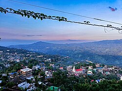 A bird's eye view of Haflong town from Synod view point (altitude: 593 mt amsl approx). | |
 Haflong  Haflong  Haflong | |
| Coordinates: 25°10′08″N93°00′58″E / 25.169°N 93.016°E | |
| Country | |
| State | Assam |
| District | Dima Hasao |
| Government | |
| • Body | Haflong Municipal Board |
| Area | |
• Total | 12.79 km2 (4.94 sq mi) |
| Elevation | 966.216 m (3,170.00 ft) |
| Population (2011) [1] | |
• Total | 43,756 |
| • Density | 3,421/km2 (8,861/sq mi) |
| Languages | |
| • Lingua franca | Haflong Hindi [2] |
| • Most common | Bengali, Dimasa [2] |
| Time zone | UTC+5:30 (IST) |
| PIN | 788819 & 788820 |
| Telephone code | 03673 |
| ISO 3166 code | IN-AS |
| Vehicle registration | AS 08-X XXXX |
Haflong is a town and headquarters of Dima Hasao district (formerly North Cachar Hills) in the state of Assam in India. It is the only hill station in Assam. [3]