Related Research Articles

Manipur, historically known as Kangleipak, is a state in northeast India, with the city of Imphal as its capital. It is bounded by the Indian states of Nagaland to the north, Mizoram to the south and Assam to the west. It also borders two regions of Myanmar, Sagaing Region to the east and Chin State to the south. The state covers an area of 22,327 km2 (8,621 sq mi). The official and most widely spoken language is the Meitei language. Native to the Meitei people, it is also used as a lingua franca by smaller communities, who speak a variety of other Tibeto-Burman languages. Manipur has been at the crossroads of Asian economic and cultural exchange for more than 2,500 years. This exchange connects the Indian subcontinent and Central Asia to Southeast Asia, East Asia, Siberia, regions in the Arctic, Micronesia and Polynesia enabling migration of people, cultures and religions.

Dima Hasao district, is an administrative district in the state of Assam, India. As of 2011, it is the least populous district of Assam.

Darjeeling District is the northernmost district of the state of West Bengal in eastern India in the foothills of the Himalayas. The district is famous for its hill station and Darjeeling tea. Darjeeling is the district headquarters.
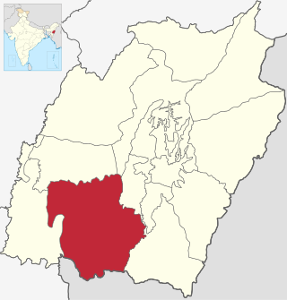
Churachandpur District, is one of the 16 districts of the Indian state of Manipur populated mainly by Kuki-Zomi people. The name honours former Maharaja Sir Churachand Singh of Manipur. The district headquarters is located in the Churachandpur town, which is also locally known by the name Lamka.

Chandel district is one of the 16 districts of Manipur state in northeastern India. Its headquarters is the town of Chandel. In December 2016, a part of the district was split to establish the new Tengnoupal district.

Senapati, is one of the 16 districts of the Indian state of Manipur. The present Senapati district was formed in December 2016, after spawning off the Sadar Hills region in the south into a separate Kangpokpi district. The district headquarter is located in the municipality of Tahamzam.

Ukhrul district is an administrative district of the state of Manipur in India with its headquarters at Ukhrul. The Ukhrul district has a long history dating back to the 1920s when it was created as the North-East Hill Sub-Division of the then princely state of Manipur. In 2016, the Kamjong subdivision of the Ukhrul district was spun out as a separate district, leading to the present configuration of the Ukhrul district.
The administrative divisions of India are subnational administrative units of India; they are composed of a nested hierarchy of administrative divisions.

The Sixth Schedule of the Constitution of India allows for the formation of autonomous administrative divisions which have been given autonomy within their respective states. Most of these autonomous district councils are located in North East India with the exception of two in Ladakh and one in West Bengal. Presently, 10 Autonomous Councils in Assam, Meghalaya, Mizoram and Tripura are formed by virtue of the Sixth Schedule with the rest being formed as a result of other legislation.
Churachandpur, locally known as Lamka, is the second largest town in the Indian state of Manipur and the district headquarters of the Churachandpur District. The name "Churachandpur" was transferred from the earlier headquarters of the district at Songpi to the present location, and honours Churachand Singh, former maharaja of the Manipur princely state. The local people reject the name as a colonial imposition and use the native name "Lamka".
Kangpokpi, is the headquarter of Kangpokpi district and the Sadar Hills Autonomous District Council in the Indian state of Manipur.
Indian Gorkhas, also known as Nepali Indians, are Nepali language-speaking Indians inhabiting mainly the states of Sikkim, West Bengal, Northeast and Uttarakhand, including their diaspora elsewhere in India and abroad. The modern term "Indian Gorkha" is used to differentiate the Nepali language Speaking Indians from Nepalis.

Khoirao, also known as Thangal, is a Sino-Tibetan language spoken in Manipur, India. The speakers of this language use Meitei language as their second language (L2) according to the Ethnologue.
The Naga Hills District was a former district of the Assam province of British India. Located in the Naga Hills, it was mainly inhabited by the Naga ethnic groups. The area is now part of the state of Nagaland.
The Mate people are one of the Kuki tribes of Manipur, India. The Mates – a name, in its literal sense, connotes front beaters and consequently, in the broadest sense as a designation, implies a migratory people – are a little-known tribal community of Manipur, India, whose socio-cultural identity as a distinct tribe was only recently recognised by the Union Government of India and the State Government of Manipur. The Mates achieved recognition as a scheduled tribe in January 2012.

Sadar Hills is a geographic area in the state of Manipur in North East India.
Saikul is the headquarters of Sadar Hills East subdivision and one of the principal towns under Sadar Hills Autonomous District Council in Manipur state of India. It is also the 46th reserved Assembly Constituency for Scheduled Tribes of the Manipur State Legislative Assembly. The town is located at 790 meters above sea level, 40 kilometres to the north of Imphal. It lies between NH-39 and NH-150 and the river Jildung passes beside the town.
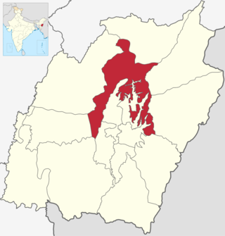
Kangpokpi district is one of the 16 districts in the Indian state of Manipur. It was created in December 2016 from areas in the Sadar Hills region which were previously part of Senapati District.
The hill tribes of Northeast India are hill people, mostly classified as Scheduled Tribes (STs), who live in the Northeast India region. This region has the largest proportion of scheduled tribes in the country.
References
- ↑ "Autonomous District Councils Manipur in brief By Haokholal Hangshing". e-pao.net. Retrieved 19 May 2022.
- ↑ "Councillors" (PDF).
- ↑ "Headquarters".
- ↑ "Autonomous District Council – Manipur". manipur.gov.in. Retrieved 19 May 2022.