Saurashtra (region)

Last updated

Saurashtra
Kathiyawad
Region
Saurashtra region within Gujarat India relief map.jpg
Saurashtra region within Gujarat, India
India Saurashtra locator map.svg
Location of Saurashtra in India
Coordinates: 22°18′00″N70°47′00″E / 22.3000°N 70.7833°E / 22.3000; 70.7833
CountryIndia
State Gujarat
Area
  Total66,000 km2 (25,000 sq mi)
Population
 (2011)
  Total15,300,000
  Density230/km2 (600/sq mi)
Languages
  Gujarati Gujarati
Time zone UTC+5:30 (IST)
Vehicle registration GJ
Large cities Botad, Rajkot, Jamnagar, Bhavnagar, Morbi, Gir Junagadh, Porbandar, Veraval, Surendranagar,

Saurashtra, also known as Kathiawar , [1] is a peninsular region of Gujarat, India, located on the Arabian Sea coast. It covers about a third of Gujarat state, notably 11 districts of Gujarat, including Rajkot District. It was formerly a state of India before it merged with Bombay state. In 1961 it separated from Bombay and joined Gujarat.

Contents

Location

Saurashtra peninsula is bound on the south and south-west by the Arabian sea, on the north-west by the Gulf of Kutch and on the east by the Gulf of Khambhat. From the apex of these two gulfs, the Little Rann of Kutch and Khambhat, waste tracts half salt morass half sandy desert, stretch inland towards each other and complete the isolation of Kathiawar, except one narrow neck which connects it on the north-east with the mainland of Gujarat. [2] [3]

The peninsula is sometimes referred to as Kathiawar after the Kathi Darbar, which once ruled most of the region. However, Saurashtra is not entirely synonymous with Kathiawar, since a small portion of the historical Saurashtra region extends beyond the Kathiawar peninsula. Sorath forms the southern portion of the peninsula.

"Sau" means 100 and "rasthra" means languages and Sourasthra is made up with 100 languages so there isn't one original word.

According to few experts, the name Saurashtra is derived from Saura Rashtra. In Sanskrit, Saura means Sun and Rashtra means country. It means, country of Sun, and there were 12 sun temples in ancient times in this region. Due to continued Islamic invasions, the idols of deities of these temples were moved to other places, one of those is located at Kanakaditya Temple at Kasheli near Pawas in Ratnagiri district of Maharashtra. The location of other 11 idols are currently unknown.

Districts

The Saurashtra region comprises the south western part of modern Gujarat state and the districts included in this region are:

The region also historically encompassed the Diu district of the Dadra and Nagar Haveli and Daman and Diu union territory. [4]

History

Referred to as Saurashtra and as some other names as well over a period of time, since the Mahabharata and Vedic period, this region is mentioned again as Surastrene, or Saraostus in the first century CE Periplus of the Erythraean Sea:

"Beyond the gulf of Baraca is that of Barygaza and the coast of the country of Ariaca, which is the beginning of the Kingdom of Nambanus and of all India. That part of it lying inland and adjoining Scythia is called Abiria, but the coast is called Syrastrene. It is a fertile country, yielding wheat and rice and sesame oil and clarified butter, cotton and the Indian cloths made therefrom, of the coarser sorts. Very many cattle are pastured there, and the men are of great stature and black in colour. The metropolis of this country is Minnagara, from which much cotton cloth is brought down to Barygaza.

Periplus, Chap. 41
Map of ancient Indian kingdoms EpicIndia.jpg
Map of ancient Indian kingdoms

In earliest foreign mention, Egyptian mathematician, geographer, astrologer Claudius Ptolemy and Greek manuscript Periplus both call this region "Surastrene"

Saurashtra and its Prakrit name Sorath, literally means "good country". The name finds mentions in the Junagadh Rock inscription dating 150 CE, attributed to Rudradaman I. Prior to this, during the rule of Ashoka (268–232 BCE), the region was under Yavana Tushaspa, and governed by Pushyagupta during Chandragupta Maurya's reign (322BC – 298BC). [5] From the 8th to 11th century, Brahmin merchants from Saurashtra region started migrating towards Southern India due to the frequent Muslim invasions, these merchants upon the invitation of Chola, Pandya, Vijayanagara, Nayak and Thanjavur Maratha Kings set up mercantile silk-weaving guilds throughout Southern India and were involved in the trade of silk clothes and diamonds to the royal families of ancient South India, as the silk became the attire of royal families after the period of Gupta dynasty. These Brahmins who trace their ancestry to the historical region of Saurashtra are now known as the Saurashtra people. [6] Several historians believe that it was Saurashtrian textile merchants who introduced idly to South India during the 10th and 12th centuries. There are even claims that a mix of rice and urad dal ground together and later steamed to form cakes had its origins in Gujarat. This was called Iddada. [7]

Gir

For a long time, the name Sorath referred to this region. From the 9th to 14th century Chudasama Rajput ruled Sorath with their capitals Vanthali and Junagadh alternatively. The Chudasama Rajputs ruled Sorath longer than any others, until the Sorath area came under Muslim rule. Sorath, a Muslim name of Saurashtra, was initially one of ten prants, but by the colonial age it was one of only four surviving ones, the others being absorbed. The salute state Junagadh (alias "Junagarh" or the "Old Fort"), founded during British rule, and its neighbouring states were controlled by the Western India States Agency (WISA). In 1947, Junagadh's Muslim ruler desired to accede his territory to Pakistan, but the predominantly Hindu population rebelled.[ citation needed ]

Saurashtra State

United Saurashtra (Kathiawar) State 1947-56 SaurashtraKart.jpg
United Saurashtra (Kathiawar) State 1947-56

After India's independence in 1947, 217 princely states of Kathiawar, including the former Junagadh State, were merged to form the state of Saurashtra on 15 February 1948. Initially, it was named United State of Kathiawar, which was renamed to Saurashtra State in November 1948. The exercise took up a lot of Shri Vallabhbhai Patel's time to convince the local princes and petty subas (totalling 222 in Saurashtra alone). However, Maharaja Krishnakumar Sinhji of Bhavnagar State readily extended to offer his large and royal empire of Bhavnagar / Gohilwar to Sardar Vallabhbhai Patel, and Bhavnagar became the first in the country to be merged into the union of India.

The capital of Saurashtra was Rajkot. Uchharangray Navalshankar Dhebar, who later went on to become President of the Indian National Congress between 1955 and 1959, became Saurashtra's first Chief Minister. He was succeeded by Rasiklal Umedchand Parikh on 19 December 1954.

On 1 November 1956, Saurashtra was merged into Bombay state. In 1960 Bombay state was divided along linguistic lines into the new states of Gujarat and Maharashtra. The territory of Saurashtra, including Junagadh and all of Sorath, became part of the state of Gujarat. [ citation needed ]

Language

Saurashtra (alternate names and spellings: Sourashtra, Sowrashtra, Palkar) is also the name of an Indo-Aryan language of Kathiawar-Saurashtra. Though, the local language is known as Kathiawadi referring to this area known also as Kathiawar and/or Gujarati language as it is part of Gujarat region; Saurashtra language referred to in original write up and also as main article above is the name of the language being referred to as prevalent in the area of Southern India which is described further below and spoken in the region by people of this region who migrated to Southern India - especially Karnataka (Bengaluru), Tamil Nadu (Ambur, Madurai, Dindigul, Paramakudi, Salem, Tanjore, Pudukkottai, Trichy, Namakkal, Kanyakumari, Kanchipuram, Walajapet, Arani, Chennai, Palayamkottai, Kumbakonam, Thirubuvanam) and Andhra Pradesh - still preserve and speak the language. The script of this language is derived from the Devanagari script and shares similarities with modern-day Gujarati. [8]

Postage stamps

The first postage stamps of the state were issued for Princely State of Junagadh in 1864. They consisted of three lines of Hindi script in colourless letters on black, and were produced by hand-stamping with watercolor ink. A second issue in 1868 used coloured letters, printed in black or red on several colours of paper.

The issue of 1877 was the first to include Latin letters; the circular design included the inscription "SORUTH POSTAGE" at the top, and "ONE ANNA OF A RUPEE" (or "FOUR ANNAS...") at the bottom. Some of these were surcharged in 1913–14, followed by redesigned stamps in 1914.

A set of eight stamps in 1929 included pictures of Junagadh, the Gir lion, and the Kathi horse in addition to the nawab. In 1937 the one anna value was reissued reading "POSTAGE AND REVENUE".

The Indian province of Saurashtra did not design any of its own stamps, but before adopting the stamps of India, Saurashtra issued a court fee stamp overprinted for postal use, then created more one anna stamps by surcharging three stamps of the 1929 issue.

Natural resources

Saurashtra between Gulf of Kutch and Gulf of Khambat. Image NASA Earth Observatory. Gujarat Gulfs.jpg
Saurashtra between Gulf of Kutch and Gulf of Khambat. Image NASA Earth Observatory.

Saurashtra has been a flourishing region and rich in natural resources since ancient times, while having gone through several droughts especially during the 20th century. Water resources and its related dynamics have influenced the region and its agro-economy to a certain extent. It is found that water was easily available in the region 10 to 15 years ago. Ashvin A. Shah, a US-based engineering consultant who conducted a survey in 1998 on water availability in the region, says, "The presence of 700,000 dugwells in Saurashtra region indicates the presence of extensive groundwater aquifers throughout the region. This means there is one well for fewer than 20 people or one well every 300 metres".

Amri Saurashtra went through severe droughts over the years to the extent that people could no longer grow crops, nor did they have drinking water available. There has been in recent times a campaign to take up rain water harvesting. [9]

Significantly, the Check dam campaign from the late 1990s brought almost a drastic change resulting in raising water tables in Saurashtra. [10] However, in 2019, the region was hit with a severe drought, affecting 20 districts in Gujarat, and water had to be brought in by tanker from the Sardar Sarovar Dam on the Narmada River. [11]

Related Research Articles

<span class="mw-page-title-main">Kathiawar</span> Peninsula in Western India

Kathiawar is a peninsula, near the far north of India's west coast, of about 61,000 km2 (23,500 sq mi) bordering the Arabian Sea. It is bounded by the Gulf of Kutch in the northwest and by the Gulf of Khambhat in the east. In the northeast, it is connected to the rest of Gujarat and borders on the low, fertile hinterland of Ahmedabad. It is crossed by two belts of hill country and is drained radially by nine rivers which have little natural flow aside from in monsoon months, thus dams have been built on some of these. Kathiawar ports have been flourishing centres of trade and commerce since at least the 16th century.

<span class="mw-page-title-main">Junagadh</span> City in Gujarat, India

Junagadh is the city and headquarters of Junagadh district in the Indian state of Gujarat. Located at the foot of the Girnar hills, 355 kilometres (221 mi) southwest of Ahmedabad and Gandhinagar, it is the seventh largest city in the state.

<span class="mw-page-title-main">Samaldas Gandhi</span> Indian journalist

Samaldas Gandhi (1897-1953) was a journalist and Indian independence activist who headed the Aarzi Hakumat or Provisional Government of the erstwhile princely state of Junagadh. He was a nephew of Mahatma Gandhi.

<span class="mw-page-title-main">Halar</span> Historical region in Gujarat, India

Halar (Haalaar) is a historical region of western India, located by the Gulf of Kutch coast on the northwestern area of Nawanagar, now Jamnagar, in Gujarat State, on Saurashtra peninsula, roughly corresponding to the present Jamnagar District, Devbhumi Dwarka district, Morbi District and Rajkot District.

Una is a town and a municipality in Gir Somnath district of the Saurashtra region in the state of Gujarat, India.

Saurashtra may refer to:

<span class="mw-page-title-main">Geography of Gujarat</span> Geography of the Indian state of Gujarat

Gujarat is a state in Western India. It has the India's Longest Coastline of 1214 km and It also has the one of the Largest Salt Desert in the World with the Area of 7500 Sq. km.

Saurashtra Railway came into being in April, 1948 with the amalgamation of state railways like Bhavnagar State Railway, Gondal Railway, Porbandar Railway, Jamnagar & Dwarka Railway, Morvi Railway, Dhrangadhra Railway, Okhamandal State Railway, Junagadh State Railway, Baria State Railway, Rajpipla Railway etc.

<span class="mw-page-title-main">Bhal region</span> Place in Gujarat, India

The Bhal region is an area of Gujarat, India. It is spread across the political boundaries of the districts of Bhavnagar, Ahmedabad, and Anand. The Bhal region is situated on the deltas of the Sabarmati, Bhogawo, Bhadar, Lilka and other rivers that flow east and southeast off the Kathiawar peninsula into the Gulf of Cambay. The word Bhaal seems to have been derived from the Sanskrit word भाल which means forehead. Such a name is given to this region probably because it is mostly as flat as a forehead with almost entire region's soil without any stones, pebbles or gravel.

<span class="mw-page-title-main">Saurashtra (state)</span> Former State of the India Union

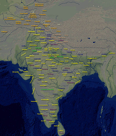
Saurashtra State, formally known as United State of Kathiawar and later United State of Saurashtra, was a State of India that existed between 1948 and 1956, on Saurashtra alias Kathiawar peninsula, with Rajkot as its capital,

Mavjinjava is a small village near Bagasara in the Amreli district of the Saurashtra region in the state of Gujarat, India. There is a population of around 3,754 people in Mavjinjava. More than 3000 people live outside of Manjinjava in places like Surat, Ahmedabad & Mumbai.

<span class="mw-page-title-main">Viramgam–Okha line</span>

The Viramgam–Okha line is a railway passing through Gujarat State, in western India. Which is branch of Gandhidham–Ahmedabad main line that connects Ahmedabad with major cities like Rajkot, Jamnagar, Surendranagar, Dwarka and also produces branch line for Bhavnagar, Junagadh, Morbi, Veraval and Porbander. Recently it has been fully electrified and there is double line section up to Rajkot.

Chamardi is a large village located within the Vallabhipur Taluka township of the Bhavnagar district (Gujarat), in West India. It was formerly a part of Rajput princely state.

<span class="mw-page-title-main">Chudasama dynasty</span> Indian dynasty

The Chudasama dynasty ruled parts of the present-day Saurashtra region of Gujarat state in India between the 9th and 15th centuries. Their capital was based in Junagadh and Vamanasthali.

Bhadli is a village and former princely state on Saurashtra peninsula in Gujarat, western India.

The Chitravav (Divani) is a village in Rajkot Taluka of Rajkot district, Gujarat, India and former petty Rajput princely state.

<span class="mw-page-title-main">Chronology of Chudasama dynasty</span>

The early history of Chudasama dynasty of Saurashtra is almost lost. The bardic legends differs very much in names, order and numbers so they are not considered reliable. Mandalika Kavya, a Sanskrit poem by Gangadhara, gives some information on dynasty but it has little historical value. Some of their inscriptions gives their early genealogy but they too differ in order of succession. Ranchhodji Diwan, A. K. Forbes, James Burgess and Gaurishankar Oza had tried to fix genealogy and chronology. Based on the dates of the inscriptions assigned to Chudasama kings and other literary sources, the genealogy and chronology of latter half of the dynasty can be established fairly. Still it is certain that they ruled about from about Vikram Samvat (VS) 900 to VS 1527.

Ra Jayasimha II was a Chudasama king of Saurashtra region of western India who reigned from 1416 CE to 1430 CE. His capital was at Junagadh.

The Gohil dynasty or Gohil or Guhilas of Saurashtra ruled parts of Saurashtra region of present-day Gujarat state of India as subordinates or independents starting 12th century. Their origin is traced to Guhila dynasty of Gujarat and they had migrated to Saurashtra in 12th century. The earliest known inscription of Gohils is found from Mangrol. They later moved to the east coast where they established themselves and the region came to be known as Gohilwar and ruled till the independence of India in 1947. The erstwhile princely states of Bhavnagar, Palitana, Lathi, Vala and Rajpipla belonged to Gohil rulers.

<span class="mw-page-title-main">Railways in Kathiawar</span>

Kathiawar is a peninsula which today forms part of the Indian state of Gujarat. The peninsula covers an area of 23,345 sq. miles and in 1901 had a population of 2,645,805.

References

  1. Ray, Bharati (2009). Different Types of History. Pearson Education India. p. 365. ISBN   9788131718186.
  2. Gazetteer of the Bombay Presidency: Káthiáwár. Vol. 8 1884, p. 3.
  3. Dave, Puffy I (October 2009). "Preservation of Kathiawari folk literature and arts". Indian Journal of Traditional Knowledge. CSIR. 8 (4): 626–628. ISSN   0975-1068 via NISCAIR Online Periodicals Repository.
  4. History of Diu – Diu Tourism Department – India
  5. Tej Ram Sharma (1978). Personal and geographical names in the Gupta inscriptions. Concept Publishing Co., Delhi. p. 211.
  6. "Saurashtra: A Language, Region, Culture & Community". Sapovadia's Blog. 3 April 2012.
  7. "Celebrating the moon-faced health food on World Idli Day". OnManorama. Retrieved 1 April 2020.
  8. "Saurashtra". Ethnologue. Retrieved 26 February 2018.
  9. "Water in the wells". rainwaterharvesting.org.
  10. "Check-dams raise water table in Saurashtra". The Times of India . Archived from the original on 28 September 2013.
  11. Langaahmedabd, Mahesh (10 May 2019). "Gujarat in the grip of massive water shortage". The Hindu. ISSN   0971-751X . Retrieved 10 May 2019.