Junagadh district

Last updated
Junagadh district
Bahauddin Maqbara - Junagadh - Gujarat - 002.jpg
Mul Dwarka Temple at Visavada Porbandar Gujarat India.jpg
Jain temples on Girnar mountain aerial view.jpg
Shil beach,gujarat.jpg
Majestic Asiatic Lions in Devalia Safari Park, Gir National Forest Park.jpg
Clockwise from top-left: Bahauddin Maqbara in Junagadh, Mul Dwarka temple in Visavadar, Shil beach, lions in Devalia Safari Park, Girnar Jain temples
Junagadh district
Interactive Map Outlining Junagadh District
Junagadh in Gujarat (India).svg
Location of district in Gujarat
Coordinates: 21°31′N70°27′E / 21.517°N 70.450°E / 21.517; 70.450
CountryFlag of India.svg  India
State Gujarat
Region Saurashtra
Headquarters Junagadh
Area
  Total5,093 km2 (1,966 sq mi)
Population
 (2011) [1]
  Total1,525,605
  Density300/km2 (780/sq mi)
Languages
  Official Gujarati, Hindi
Time zone UTC+5:30 (IST)
PIN
362001
Vehicle registration GJ 11
Website junagadh.nic.in

Junagadh district is a district of the Indian state of Gujarat. Its administrative headquarters is the city of Junagadh.

Contents

Geography

The district is located on the Kathiawar peninsula in western Gujarat. It is surrounded by Rajkot district (north), Porbandar District (north-west), and Amreli district (east). To the south and west is the Arabian Sea.

Porbandar was earlier a part of this district, before the Porbandar district was carved out of Junagadh district.[ citation needed ]

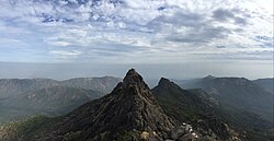
Junagadh has a mountain range called Girnar which is a place of pilgrimage for Hinduism and Jainism.

Divisions

Talukas of Junagadh are Junagadh City, Bhesan subdistrict, Junagadh Rural, Keshod, Malia, Manavadar, Mangrol, Mendarda, Vanthali, and Visavadar. [2]

Transportation

Junagadh is well connected by road and railway networks. It is about 100 km from Rajkot and 350 km from Ahmedabad. National highway 8D connects Junagadh to Rajkot via Jetpur.

Junagadh railway station is also well connected with Rajkot, Ahmedabad. It is in the city area. Junagadh also has an airport at Keshod which has limited connectivity with Mumbai.

The district has a long shoreline and has ports including Veraval, Mangrol, and Chorwad. However, it has limited use other than the fishery industry.

As of October 2011, the government of India had given its approval for a ropeway on Mount and in 2021 it was completed and was inaugurated by Prime Minister Narendra Modi. In the past, helicopter service was available for Mount Girnar but it is now discontinued.

Demographics

Historical population
YearPop.±% p.a.
1901415,521    
1911458,829+1.00%
1921491,969+0.70%
1931579,792+1.66%
1941729,508+2.32%
1951829,760+1.30%
19611,051,074+2.39%
19711,408,342+2.97%
19811,813,780+2.56%
19912,091,182+1.43%
20012,448,173+1.59%
20112,743,082+1.14%
source: [3]

According to the 2011 census Junagadh district has a population of 2,743,082, [1] roughly equal to the nation of Jamaica [4] or the US state of Utah. [5] This gives it a ranking of 142nd in India (out of a total of 640). [1] The district has a population density of 310 inhabitants per square kilometre (800/sq mi). [1] Its population growth rate over the decade 2001–2011 was 12.01%. [1] Junagadh has a sex ratio of 952 females for every 1000 males. [1] It had a literacy rate of 67.7% in 2001 which increased to a literacy rate of 76.88% in 2011. [1]

The divided district has a population of 1,525,605, of which 573,403 (37.59%) lived in urban areas. Junagadh had a sex ratio of 945 females per 1000 males. Scheduled Castes and Scheduled Tribes are 151,971 (9.96%) and 37,810 (2.48%) of the population respectively. [1]

Religions in Junagadh district (2011) [6]
Hinduism
88.38%
Islam
11.17%
Other or not stated
0.45%
Distribution of religions

Hindus are 1,348,315 (88.38%) and Muslims 170,338 (11.17%) of the population respectively. [6]

Gujarati was the predominant language, spoken by 97.44% of the population. [7]

Politics

DistrictNo.ConstituencyNamePartyRemarks
Junagarh 85 Manavadar Arvindbhai Ladani Indian National Congress
86 Junagadh Sanjay Koradiya Bharatiya Janata Party
87 Visavadar Bhupendra Bhayani Aam Aadmi Party Resigned on 13 December 2023 [8]
Vacant
88 Keshod Devabhai Malam Bharatiya Janata Party
89 Mangrol (Junagadh) Bhgwanjibhai Kargatiya Bharatiya Janata Party

Notable personalities

Flora and fauna

Junagadh contains the Gir Forest National Park, which is the only home to Asiatic lions. Mount Girnar is also declared a forest reserve for bamboo. Girnari Giddh, the long-billed vultures, are found only on Girnar, as the Girnar region alone accounts for about 25 per cent of the species and about 10 per cent of the total vulture population in the Gujarat state.

Education

Junagadh Agricultural University is famous here. Other educational institutes include:

Related Research Articles

<span class="mw-page-title-main">Porbandar</span> City in Gujarat, India

Porbandar is a city in the Indian state of Gujarat, perhaps best known for being the birthplace of Mahatma Gandhi and Sudama. It is the administrative center of the Porbandar District and it was the former capital of the Porbandar princely state.

<span class="mw-page-title-main">Kathiawar</span> Peninsula in Western India

Kathiawar is a peninsula, near the far north of India's west coast, of about 61,000 km2 (23,500 sq mi) bordering the Arabian Sea. It is bounded by the Gulf of Kutch in the northwest and by the Gulf of Khambhat in the east. In the northeast, it is connected to the rest of Gujarat and borders on the low, fertile hinterland of Ahmedabad. It is crossed by two belts of hill country and is drained radially by nine rivers which have little natural flow aside from in monsoon months, thus dams have been built on some of these. Kathiawar ports have been flourishing centres of trade and commerce since at least the 16th century.

<span class="mw-page-title-main">Junagadh</span> City in Gujarat, India

Junagadh is the city and headquarters of Junagadh district in the Indian state of Gujarat. Located at the foot of the Girnar hills, 355 kilometres (221 mi) southwest of Ahmedabad and Gandhinagar, it is the seventh largest city in the state.

<span class="mw-page-title-main">Sabarkantha district</span> District of Gujarat in India

Sabarkantha district is one of the 33 districts of Gujarat state of India, located in the northeastern part of the state. The administrative headquarters of the district are located in Himatnagar.

<span class="mw-page-title-main">Ahmedabad district</span> District of Gujarat in India

Ahmedabad district comprises the city of [Amdavad], in the central part of the state of Gujarat in western India. It is the seventh most populous district in India.

<span class="mw-page-title-main">Porbandar district</span> District of Gujarat in India

Porbandar district is one of the 33 districts of Gujarat state in western India. The district covers an area of 2,316 km2. It had a population of 5.85,449 of which 48.77% were urban as of the 2011 census. This district was carved out of Junagadh district. It lies on the Kathiawar peninsula. Porbandar city is the administrative headquarters of this district. This district is surrounded by Jamnagar district and Devboomi Dwarka to the north, Junagadh district and Rajkot district to the east and the Arabian Sea to the west and south.

<span class="mw-page-title-main">Rajkot district</span> District of Gujarat in India

Rajkot district is one of the 33 districts of the Indian state of Gujarat. Located in Saurashtra peninsula, Rajkot city is the administrative headquarters of the district. It is the third-most advanced district in Gujarat and the fourth most populus.

<span class="mw-page-title-main">Surat district</span> District of Gujarat in India

Surat is a district in the state of Gujarat, city as the administrative headquarters of this district. It is surrounded by Bharuch, Narmada (North), Navsari (South) districts and east Tapi district To the west is the Gulf of Cambay. It is the second-most advanced district in Gujarat. It had a population of 6,081,322 of which 79.68% were urban as of 2011. On 2 October 2007 Surat district was split into two by the creation of a new Tapi district, under the Surat District Re-organisation Act 2007.

<span class="mw-page-title-main">Veraval</span> City in Gujarat, India

Veraval is a city and the headquarters of Gir Somnath district in the Indian state of Gujarat. Somnath temple, a place of pilgrimage due to its importance as Jyotirlinga site dedicated to Lord Shiva, is located here. It is also known for the hub of fishing industries in India.

Bantva, or Bantwa, is a small town in Saurashtra region of the state of Gujarat in India.

Kutiyana is a city and a municipality in Porbandar district in the Indian state of Gujarat. It is situated on the banks of Bhadar River.

<span class="mw-page-title-main">Keshod</span> Town in Gujarat, India

Keshod is a town and a Taluka in Junagadh District.

Sarsai is a village of Visavadar Taluka Junagadh district, Gujarat State, India. It is located 38 kilometres (24 mi) east of district headquarters Junagadh, and 339 km (211 mi) from state capital Gandhinagar. Its Postal Index Number is 362120. It is located near Satadhar. A popular place named "sant rohidas ashsram" is in Sarsai.

<span class="mw-page-title-main">Morbi district</span> District of Gujarat in India

Morbi district is in the state of Gujarat, India. It was formed on August 15, 2013, along with several other districts, on the 67th Independence Day of India. Morbi city is the administrative headquarters of the district. The district has 5 talukas - Morbi, Maliya, Tankara, Wankaner and Halvad. Morbi city is the administrative headquarters of Morbi district. The town of Morbi is situated on the Machchhu River, 35 km from the sea and 60 km from Rajkot. As per 2011 census data, the city had a population of 2,10,451 and average literacy rate of 83.64%.

<span class="mw-page-title-main">Botad district</span> District of Gujarat in India

Botad District is a district of the state of Gujarat, India. It was created on 15 August 2013 from the southwestern part of Ahmedabad District and the northwestern part of Bhavnagar District. Botad consist of four talukas: Botad, Gadhada, Barvala, Ranpur. Botad city is the administrative headquarters of the district.

Visavadar is one of the 182 Legislative Assembly constituencies of Gujarat state in India. It is part of Junagadh district and a segment of Junagadh Lok Sabha constituency.

Bagasara-Ghed, also known as Bagasara (Sil), is a village in Mangarol Taluka of Junagadh district, Gujarat, India. Bagasra-Ghed lies thirty-four miles to the south-west of Junagadh.

Keshod railway station is a railway station serving in junagadh district of Gujarat State of India. It is under Bhavnagar railway division of Western Railway Zone of Indian Railways. Keshod railway station is 40 km far away from Junagadh Junction. Passenger, Express trains halt here.

References

  1. 1 2 3 4 5 6 7 8 "District Census Hand Book – Junagadh" (PDF). Census of India . Registrar General and Census Commissioner of India.
  2. "Bhesan". 2011 Census of India . Government of India. Archived from the original on 28 November 2017. Retrieved 1 December 2017.
  3. Decadal Variation In Population Since 1901
  4. US Directorate of Intelligence. "Country Comparison:Population". Archived from the original on June 13, 2007. Retrieved 2011-10-01. Jamaica 2,868,380 July 2011 est
  5. "2010 Resident Population Data". U. S. Census Bureau. Archived from the original on 2011-01-01. Retrieved 2011-09-30. Utah 2,763,885
  6. 1 2 "Population by Religion - Gujarat". censusindia.gov.in. Registrar General and Census Commissioner of India. 2011.
  7. "Table C-16 Population by Mother Tongue: Gujarat". censusindia.gov.in. Registrar General and Census Commissioner of India.
  8. "Gujarat AAP MLA Bhupendra Bhayani resigns, set to join BJP". The Hindu. 2023-12-13. ISSN   0971-751X . Retrieved 2023-12-14.