Gandhinagar district

Last updated

Gandhinagar district
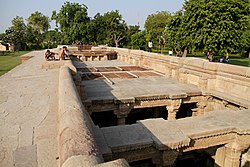
Step well partial top view of inverted temple, Gujarat India.jpg
Gandhinagar district
Interactive Map Outlining Gandhinagar District
Gandhinagar in Gujarat (India).svg
Location of district in Gujarat
Coordinates: 23°12′53.42″N72°38′59.42″E / 23.2148389°N 72.6498389°E / 23.2148389; 72.6498389
CountryFlag of India.svg  India
State Gujarat
Headquarters Gandhinagar
Area
  Total2,140 km2 (830 sq mi)
Population
 (2011)
  Total1,391,753
  Density650/km2 (1,700/sq mi)
Languages
  Official Gujarati, Hindi, English
Time zone UTC+5:30 (IST)
Vehicle registration GJ 18
Website gandhinagar.nic.in

Gandhinagar district is an administrative division of Gujarat, India, whose headquarters are at Gandhinagar, the state capital. It was organized in 1964.

Contents

It has an area of 2140 km2, and a population of 1,391,753 of which 43.16% lives in urban regions (2011 census). [1] The district includes Gandhinagar with two Suburbs - Motera, Adalaj. The four tehsils are - Gandhinagar, Kalol, Dahegam and Mansa - and 216 villages.

Gandhinagar district is bounded by the districts of Sabarkantha and Aravalli to the northeast, Kheda to the southeast, Ahmedabad to the southwest, and Mehsana to the northwest.

Connected to Ahmedabad by the Sarkhej-Gandhinagar highway, and with Vadodara with the Ahmedabad-Vadodara highway, these three cities form the top population centres and commercial heart of Gujarat and western India.

Because of the division of the old Mumbai State, the State of Gujarat was formed on 1 May 1960. Because of the development of the territory of Gujarat, the capital of the state was kept at Ahmedabad. At that point, to diminish populace thickness of Ahmedabad city, Gandhinagar, the new capital of the territory of Gujarat, was set up. The city of Gandhinagar was set up on 2 August 1965.

The new capital was named Gandhinagar to keep an enduring memory of the Father of the Nation Mahatma Gandhi.

Gandhinagar city is a planned city that has 30 sectors, 1 km each in length and width. Each sector has a primary school, a secondary school, a higher secondary school, a medical dispensary, a shopping centre and a maintenance office.

Gandhinagar has infocity nearby which is housing IT companies. Many big IT companies like TCS, Cybage has presence in infocity whereas PCS is located at GIDC area. Many more companies are planning to come to infocity. Etech, Inc., one of the major BPO players in Gujarat is also based here along with operations in Vadodara and Texas. [2]

Akshardham Gandhinagar is situated in Sector-20. It is one of the major Hindu Temple complex of Gujarat.

Gandhinagar has many educational institutions. With 87.11% its education level is highest in Gujarat.[ citation needed ]

Demographics

Religions in Gandhinagar district (2011) [3]
ReligionPercent
Hinduism
94.81%
Islam
4.12%
Jainism
0.46%
Other or not stated
0.61%

According to the 2011 census Gandhinagar district has a population of 1,391,753, [4] roughly equal to the nation of Eswatini [5] or the US state of Hawaii. [4] [6] The district has a population density of 650 inhabitants per square kilometre (1,700/sq mi). [4] Its population growth rate over the decade 2001-2011 was 4.29%. [4] Gandhinagar has a sex ratio of 923 females for every 1000 males. [4] It had a literacy rate of 76.59% in 2001 which rose by 7.5 percentage points in 10 years to literacy rate of 84.16% in 2011. 43.16% of the population lived in urban areas. Scheduled Castes and Scheduled Tribes made up 7.80% and 1.31% of the population respectively. [4]

Languages of Gandhinagar district (2011) [7]

   Gujarati (93.94%)
   Hindi (4.04%)
   Marathi (0.37%)
   Marwari (0.27%)
   Sindhi (0.23%)
   Malayalam (0.16%)
  Others (2.01%)

At the time of the 2011 Census of India, 93.94% of the population in the district spoke Gujarati and 4.05% Hindi as their first language. [7]

Historical population
YearPop.±%
1901222,527    
1911225,592+1.4%
1921242,815+7.6%
1931268,801+10.7%
1941327,493+21.8%
1951401,815+22.7%
1961478,611+19.1%
1971648,666+35.5%
1981835,337+28.8%
19911,016,339+21.7%
20011,237,168+21.7%
20111,391,753+12.5%
Source: Census of India

Politics

DistrictNo.ConstituencyNamePartyRemarks
Gandhinagar 34 Dahegam Balrajsinh Chauhan Bharatiya Janata Party
35 Gandhinagar South Alpesh Thakor Bharatiya Janata Party
36 Gandhinagar North Ritaben Patel Bharatiya Janata Party
37 Mansa Jayantibhai Patel (J S Patel) Bharatiya Janata Party
38 Kalol (Gandhinagar) Laxmanji Thakor Bharatiya Janata Party

Tourism

A blend of heritage, history and culture, Gandhinagar is one of the most harmonious cities that one can ever visit. A home to the Akshardham Temple that is adorned with pink stone and beautiful carving, Gandhinagar also houses: [8]

Related Research Articles

<span class="mw-page-title-main">Gujarat</span> State in western India

Gujarat is a state along the western coast of India. Its coastline of about 1,600 km (990 mi) is the longest in the country, most of which lies on the Kathiawar peninsula. Gujarat is the fifth-largest Indian state by area, covering some 196,024 km2 (75,685 sq mi); and the ninth-most populous state, with a population of 60.4 million in 2011. It is bordered by Rajasthan to the northeast, Dadra and Nagar Haveli and Daman and Diu to the south, Maharashtra to the southeast, Madhya Pradesh to the east, and the Arabian Sea and the Pakistani province of Sindh to the west. Gujarat's capital city is Gandhinagar, while its largest city is Ahmedabad. The Gujaratis are indigenous to the state and their language, Gujarati, is the state's official language.

<span class="mw-page-title-main">Gandhinagar</span> Capital city of Gujarat, India

Gandhinagar is the capital of the state of Gujarat in India. Gandhinagar is located approximately 23 km north of Ahmedabad, on the west central point of the industrial corridor between the metropolitan cities of Delhi and Mumbai.

<span class="mw-page-title-main">Vadodara</span> Metropolis in Gujarat, India

Vadodara, also known as Baroda, is a major city in the Indian state of Gujarat. It serves as the administrative headquarters of the Vadodara district and is situated on the banks of the Vishwamitri River, 141 km (88 mi) from the state capital of Gandhinagar. The railway line and National Highway 8, which connect Delhi with Mumbai, pass through Vadodara. The city is named for its abundance of banyan (vad) trees. Vadodara is also locally referred to as the Sanskari Nagari and Kala Nagari of India.

<span class="mw-page-title-main">Sabarkantha district</span> District of Gujarat in India

Sabarkantha district is one of the 33 districts of Gujarat state of India, located in the northeastern part of the state. The administrative headquarters of the district are located in Himatnagar.

<span class="mw-page-title-main">Mehsana</span> City in Gujarat, India

Mehsana, also spelled Mahesana, is a city and the headquarters of Mehsana district in the Indian state of Gujarat. Established in 14th century, the city was under Gaekwads of Baroda State from 18th century to the independence of India in 1947. Dairy, oil and natural gas are major industries in the city.

<span class="mw-page-title-main">Anand, Gujarat</span> City in Gujarat, India

Anand is the administrative centre of Anand District in the state of Gujarat, India. It is administered by Anand Municipal Corporation. It is part of the region known as Charotar, consisting of Anand and Kheda districts.

<span class="mw-page-title-main">Amreli district</span> District of Gujarat in India

Amreli district is one of the 33 administrative districts of the state of Gujarat in western India. The district headquarters are located at Amreli. The district occupies an area of 6,760 km2 and has a population of 1,514,190 of which 22.45% were urban. Amreli is the land of Yogiji Maharaj(Dhari), Danbapu, Sage Muldas, Sage Bhojalrambapa, Sage Muktanand Swami, Magician K.Lal, Zaverchand Megahani's place (Bagasara), Dr. Jivaraj Mehata etc. Amreli covers Dhari Gir National forest sanctuary area. Now it is developing as a Hub of Education.

<span class="mw-page-title-main">Narmada district</span> District of Gujarat in India

Narmada district is an administrative district in the state of Gujarat in India. The district headquarters are located at Rajpipla. The district is bounded by Vadodara and Chhota Udaipur districts in the north, by Nandurbar district of Maharashtra state in the east, by Surat and Tapi districts in the south and by Bharuch district in the west. The district occupies an area of 2,755 km2 and has a population of 590,297. It was 10.44% urban as of 2011. As of 2011, it is the third least populous district of Gujarat, after Dang and Porbandar.

<span class="mw-page-title-main">Navsari district</span> District of Gujarat in India

Navsari is an administrative district in the state of Gujarat in India, with its headquarters at the city of Navsari. The district covers an area of 2,211 square kilometres and was formed in 1997 after Valsad district was split into Valsad and Navsari districts. It is the largest producer of chikoos in India.

<span class="mw-page-title-main">Ahmedabad district</span> District of Gujarat in India

Ahmedabad district or Amdavad district, is a district comprises the city of Amdavad, in the central part of the state of Gujarat in western India. It is the seventh most populous district in India.

<span class="mw-page-title-main">Anand district</span> District of Gujarat in India

Anand District is an administrative district of Gujarat state in western India and whose popular nickname is Charotar. It was carved out of the Kheda district in 1997. Anand is the administrative headquarters of the district. It is bounded by Kheda District to the north, Vadodara District to the east, Ahmedabad District to the west, and the Gulf of Khambhat to the south. Major towns are Umreth, Khambhat, Karamsad, Tarapur, Petlad, Borsad and Sojitra.

<span class="mw-page-title-main">Kheda district</span> District of Gujarat in India

Kheda District is one of the thirty-three districts of Gujarat state in western India. It is part of the region known as Charotar, consisting of Kheda and Anand districts. Its central city Nadiad is the administrative headquarters of the district.

<span class="mw-page-title-main">Junagadh district</span> District of Gujarat in India

Junagadh district is a district of the Indian state of Gujarat. Its administrative headquarters is the city of Junagadh.

<span class="mw-page-title-main">Mehsana district</span> District of Gujarat in India

Mehsana district is one of the 33 districts of Gujarat state in western India. Mehsana city is the administrative headquarters of this district. The district has a population of over 1.8 million and an area of over 4,500 km2. There are over 600 villages in this district with a population of 2,035,064 of which 22.40% were urban as of 2011.

<span class="mw-page-title-main">Porbandar district</span> District of Gujarat in India

Porbandar district is one of the 33 districts of Gujarat state in western India. The district covers an area of 2,316 km2. It had a population of 5.85,449 of which 48.77% were urban as of the 2011 census. This district was carved out of Junagadh district. It lies on the Kathiawar peninsula. Porbandar city is the administrative headquarters of this district. This district is surrounded by Jamnagar district and Devboomi Dwarka to the north, Junagadh district and Rajkot district to the east and the Arabian Sea to the west and south.

<span class="mw-page-title-main">Rajkot district</span> District of Gujarat in India

Rajkot district is one of the 33 districts of the Indian state of Gujarat. Located in Saurashtra peninsula, Rajkot city is the administrative headquarters of the district. It is the third-most advanced district in Gujarat and the fourth most populus.

<span class="mw-page-title-main">Vadodara district</span> District of Gujarat, India

Vadodara district, also known as Baroda district, is situated in the eastern part of the state of Gujarat in western India. The administrative headquarters of the district is the city of Vadodara (Baroda). The district covers an area of 7,794 km2 and had a population of 4,165,626 as of 2011. Out of this population, 49.6% were urban, 50.4% were rural, 5.3% were Scheduled Castes and 27.6% were Scheduled Tribes. As of 2011, Vadodara district is the third most populous district of Gujarat, out of 33 districts in the state.

<span class="mw-page-title-main">Vidisha district</span> District of Madhya Pradesh in India

Vidisha District (विदिशा) is in Madhya Pradesh state, in central India. The city of Vidisha is the administrative headquarters of the district.

<span class="mw-page-title-main">Adalaj</span> Town in Gujarat, India

Adalaj is a census town in Gandhinagar district located in the western Indian state of Gujarat. With a population of roughly 12,000 residents within the town limits as of 2011, Adalaj is known for its semi-arid climate and its historic and religious establishments. The town sits in a generally flat area covering about 18 sq. km.

<span class="mw-page-title-main">Rupal, Gandhinagar</span> Village in Gujarat, India

Rupal is a village in Gandhinagar district of Gujarat state, India. It is located 13 km towards north from District headquarters Gandhinagar. Gujarati is the local language.

References

  1. "Demography | District Gandhingar,Govt. of Gujarat | India" . Retrieved 9 December 2022.
  2. "Home". etechinc.com.
  3. "Population by Religion - Gujarat". censusindia.gov.in. Registrar General and Census Commissioner of India. 2011.
  4. 1 2 3 4 5 6 "District Census Hand Book – Gandhinagar" (PDF). Census of India . Registrar General and Census Commissioner of India.
  5. US Directorate of Intelligence. "Country Comparison:Population". Archived from the original on 13 June 2007. Retrieved 1 October 2011. Swaziland 1,370,424
  6. "2010 Resident Population Data". U. S. Census Bureau. Archived from the original on 1 January 2011. Retrieved 30 September 2011. Hawaii 1,360,301
  7. 1 2 "Table C-16 Population by Mother Tongue: Gujarat". censusindia.gov.in. Registrar General and Census Commissioner of India.
  8. "Gandhinagar Travel Guide, Gujarat". Tour My India.