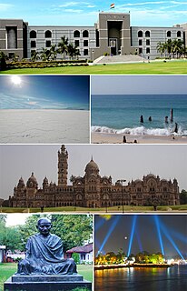
Gandhinagar is the capital of the state of Gujarat in Western India. Gandhinagar is located approximately 23 km north of Ahmedabad, on the west central point of the Industrial corridor between Delhi, the political capital of India, and Mumbai, the financial capital of India.

Panchmahal, also Panch Mahals, is a district in the eastern portion of Gujarat State western India. Panch-mahal means "five tehsils/talukas", and refers to the five sub-divisions that were transferred by the Maharaja Jivajirao Scindia of Gwalior State to the British: Godhra, Dahod, Halol, Kalol and Jhalod. The district had a population of 2,025,277 of which 12.51% were urban as of 2001. Headquarters: Godhra.

Navsari is an administrative district in the state of Gujarat in India, with its headquarters at Navsari city. The district covers an area of 2,211 square kilometres roughly equal to country like Luxembourg and the US state of Delaware, and had a population of 1,329,672 in 2011 roughly equal to country like Estonia and the US state of Hawaii. The district was formed in 1997 after Valsad district was bifurcated into Valsad and Navsari districts.

Ahmedabad District comprises the city of Ahmedabad, in the central part of the state of Gujarat in western India. It is the seventh most populous district in India.
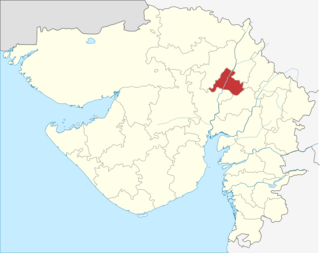
Gandhinagar district is an administrative division of Gujarat, India, whose headquarters are at Gandhinagar, the state capital. It was organized in 1964.

Patan district is one of the 33 districts of Gujarat state in western India. This district is located in northern Gujarat and bounded by Banaskantha district in the north and northeast, Mehsana district in the east and southeast, Surendranagar district in the south and Kutch District and the Kutch nu Nanu Ran in the west. The district occupies an area of 5792 km².

Mehsana district is one of the 33 districts of Gujarat state in western India. Mehsana city is the administrative headquarters of this district. The district has a population of over 1.8 million and an area of over 4,500 km². There are over 600 villages in this district with a population of 1,837,892 of which 22.40% were urban as of 2001.

Adalaj is a census town in Gandhinagar district in the Indian state of Gujarat.

Dahegam is a city and a municipality in Gandhinagar district in the state of Gujarat, India.
Kalol is a town and a municipality (tehsil) in Panchmahal district in the Indian state of Gujarat, birthplace of comic creator and singer Urmi Thaker.
Kalol assembly constituency is one of the 182 assembly constituencies of Gujarat. It is located in Gandhinagar district.
Vadsar is a village located in the Gandhinagar district of Gujarat, India. The latitude 23.1556088 and longitude 72.4724133 are the geocoordinate of the village. The population was 7,406 at the 2011 Indian census.
Sadra is a village, on the banks of Sabarmati river, in Gandhinagar Taluka in Gandhinagar district of Gujarat state, India.
Rupal is a village in Gandhinagar District of Gujarat state, India. It is located 13 KM towards
Umedpara is a village / panchayat located in the Gir Gadhada Taluka of Gir Somnath district in Gujarat State, India. Earlier, until August 2013, Umedpara was part of Una Taluka and Junagadh district. The latitude 20.909597 and longitude 70.893243 are the geo-coordinate of the Village Umedpara. Gandhinagar is the state capital of Umedpara village which is located around 400 kilometres away from Umedpara.
Bediya is a village / panchayat located in the Gir Gadhada Taluka of Gir Somnath district in Gujarat State, India. Earlier, until August 2013, Bediya was part of Una Taluka and Junagadh district. The latitude 20.971288 and longitude 71.105822 are the geo-coordinate of the Village Bediya. Gandhinagar is the state capital of Bediya village which is located around 350 kilometres away from Bediya.
Dron is a village / panchayat, located in the Gir Gadhada Taluka of Gir Somnath district in Gujarat State, India. Earlier, until August 2013, Dron was part of Una Taluka and Junagadh district. The latitude 20.928161 and longitude 70.949985 are the geo-coordinate of the Village Dron. Gandhinagar is the state capital of Dron village which is located around 362 kilometres away from Dron.
Vadli is a village / panchayat located in the Gir Gadhada Taluka of Gir Somnath district in Gujarat State, India. Earlier, until August 2013, Vadli was part of Una Taluka and Junagadh district. The latitude 21.011335 and longitude 71.081876 are the geo-coordinate of the Village Vadli. Gandhinagar is the state capital of Vadli village which is located around 400 kilometres away from Vadli.