Tapi district

Last updated

Tapi district
Tapi District.1311.jpg
River in Tapi district
Tapi district
Interactive Map Outlining Tapi District
Tapi in Gujarat (India).svg
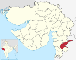
Location of district in Gujarat
Coordinates: 21°7′12″N73°24′0″E / 21.12000°N 73.40000°E / 21.12000; 73.40000
CountryFlag of India.svg  India
State Gujarat
Headquarters Vyara
Government
  BodyNagar Palika
Area
  Total3,139 km2 (1,212 sq mi)
Population
 (2011)
  Total807,022
  Density260/km2 (670/sq mi)
Languages
  Official Gujarati, Hindi
Time zone UTC+5:30 (IST)
Area code(s) 02624, 02625, 02626, 02628
Vehicle registration GJ 26
Website tapi.nic.in

Tapi district is one of the 33 districts of Gujarat state in western India. It has seven talukas Vyara, Songadh, Nizar, Valod, Uchhal, Dolavan, Kukarmunda. Vyara town is the district headquarters. Tapi has 523 villages and two municipalities. The district was formed in 2007 out of some talukas that were separated from Surat district. [1]

Contents

Demographics

Historical population
YearPop.±% p.a.
1901155,894    
1911166,720+0.67%
1921167,361+0.04%
1931183,989+0.95%
1941221,965+1.89%
1951263,380+1.73%
1961329,134+2.25%
1971457,502+3.35%
1981527,971+1.44%
1991626,979+1.73%
2001719,634+1.39%
2011807,022+1.15%
source: [2]

According to the 2011 census, Tapi district has a population of 807,022, [3] roughly equal to the nation of Comoros [4] or the US state of South Dakota. [5] This gives it a ranking of 484th in India (out of a total of 640). [3] The district has a population density of 234 inhabitants per square kilometre (610/sq mi) . [3] Its population growth rate over the decade 2001-2011 was 12.07%. [3] Tapi has a sex ratio of 1004 females for every 1000 males, [3] and a literacy rate of 69.23%. 9.85% of the population lives in urban areas. Scheduled Castes and Scheduled Tribes make up 1.01% and 84.18% of the population respectively. [3]

Religions in Tapi district (2011) [6]
Hinduism
89.95%
Christianity
6.56%
Islam
2.76%
Other or not stated
0.73%
Distribution of religions

Languages of Tapi district (2011) [7]

   Gujarati (49.09%)
   Gamit (14.53%)
   Bhili (9.96%)
   Vasavi (8.02%)
   Chodri (5.96%)
   Hindi (2.86%)
   Marathi (2.86%)
   Kukna (1.96%)
  Others (4.76%)

At the time of the 2011 Census of India, 49.09% of the population in the district spoke Gujarati, 14.53% Gamit, 9.96% Bhili, 8.02% Vasava, 5.96% Chaudhari, 2.86% Hindi, 2.86% Marathi and 1.96% Kukna as their first language. [7]

Politics

DistrictNo.ConstituencyNamePartyRemarks
Tapi 171 Vyara (ST)Mohanbhai Konkani Bharatiya Janata Party
172 Nizar (ST)Dr. Jairam Gamit Bharatiya Janata Party

Notable persons

  1. Suresh Joshi (1921–1986) Writer and academic. Born in Valod. [8]
  2. Amarsinh Bhilabhai Chaudhary, Former Chief Minister of Gujarat (July 1985 to December 1989)

Tourism

The District shares Purna Wildlife Sanctuary with the Districts of Dang and Nandurbar, the latter of which is in Maharashtra. The sanctuary is a part of the Dangs' Forest. [9] [10]

Related Research Articles

<span class="mw-page-title-main">Amreli district</span> District of Gujarat in India

Amreli district is one of the 33 administrative districts of the state of Gujarat in western India. The district headquarters are located at Amreli. The district occupies an area of 6,760 km2 and has a population of 1,514,190 of which 22.45% were urban. Amreli is the land of Yogiji Maharaj(Dhari), Danbapu, Sage Muldas, Sage Bhojalrambapa, Sage Muktanand Swami, Magician K.Lal, Zaverchand Megahani's place (Bagasara), Dr. Jivaraj Mehata etc. Amreli covers Dhari Gir National forest sanctuary area. Now it is developing as a Hub of Education.

<span class="mw-page-title-main">Dang district, India</span> District of Gujarat in India

Dang is a district in the southeastern part of the state of Gujarat in western India. The administrative headquarters of the district are located in Ahwa. Dang has an area of 1,764 km² and a population of 228,291. As of 2011, it is the least populous district of Gujarat. As per the Planning Commission, Dang is one of the most economically distressed district out of 640 districts in India. 94% of the population belongs to one of the scheduled tribes. The five Kings of Dangs are the only hereditary royals in India whose titles are currently recognized by the government owing to an agreement made during the British Raj in 1842.

<span class="mw-page-title-main">Narmada district</span> District of Gujarat in India

Narmada district is an administrative district in the state of Gujarat in India. The district headquarters are located at Rajpipla. The district is bounded by Vadodara and Chhota Udaipur districts in the north, by Nandurbar district of Maharashtra state in the east, by Surat and Tapi districts in the south and by Bharuch district in the west. The district occupies an area of 2,755 km² and has a population of 590,297. It was 10.44% urban as of 2011. As of 2011, it is the third least populous district of Gujarat, after Dang and Porbandar.

<span class="mw-page-title-main">Navsari district</span> District of Gujarat in India

Navsari is an administrative district in the state of Gujarat in India, with its headquarters at the city of Navsari. The district covers an area of 2,211 square kilometres and was formed in 1997 after Valsad district was split into Valsad and Navsari districts. It is the largest producer of chikoos in India.

<span class="mw-page-title-main">Anand district</span> District of Gujarat in India

Anand District is an administrative district of Gujarat state in western India and whose popular nickname is Charotar. It was carved out of the Kheda district in 1997. Anand is the administrative headquarters of the district. It is bounded by Kheda District to the north, Vadodara District to the east, Ahmedabad District to the west, and the Gulf of Khambhat to the south. Major towns are Umreth, Khambhat, Karamsad, Tarapur, Petlad, Borsad and Sojitra.

<span class="mw-page-title-main">Patan district</span> District in Gujarat, India

Patan district is one of the 33 districts of Gujarat state in western India. Its main city is Patan. This district is located in northern Gujarat and bounded by Banaskantha district in the north and northeast, Mehsana district in the east and southeast, Surendranagar district in the south and Kutch District and the Kutch nu Nanu Ran in the west. The district occupies an area of 5792 km².

<span class="mw-page-title-main">Kheda district</span> District of Gujarat in India

Kheda District is one of the thirty-three districts of Gujarat state in western India. It is part of the region known as Charotar, consisting of Kheda and Anand districts.. Its central city Nadiad is the administrative headquarters of the district.

<span class="mw-page-title-main">Jamnagar district</span> District of Gujarat in India

Jamnagar District is a district of Gujarat in Western India. Its headquarters are located in the eponymous city of Jamnagar. It hosts the production facilities of large Indian companies such as Reliance. Among its attractions are several palaces, a Marine National Park and a Bird Sanctuary, known as Khijadiya Bird Sanctuary. In 2013, Devbhoomi Dwarka district was carved out of the western part of the district.

<span class="mw-page-title-main">Dahod district</span> District of Gujarat in India

Dahod district is a district of Gujarat state in western India. This largely tribal district is mostly covered by forests and hills.

<span class="mw-page-title-main">Porbandar district</span> District of Gujarat in India

Porbandar district is one of the 33 districts of Gujarat state in western India. The district covers an area of 2,316 km2. It had a population of 5.85,449 of which 48.77% were urban as of 2011 census This district was carved out of Junagadh District. It lies on the Kathiawar peninsula. Porbandar city is the administrative headquarters of this district. This district is surrounded by Jamnagar district and Devboomi Dwarka to the north, Junagadh district and Rajkot district to the east and the Arabian Sea to the west and south.

<span class="mw-page-title-main">Surat district</span> District of Gujarat in India

Surat is a district in the state of Gujarat, India with Surat city as the administrative headquarters of this district. It is surrounded by Bharuch, Narmada (North), Navsari (South) districts and east Tapi district To the west is the Gulf of Cambay. It is the second-most advanced district in Gujarat. It had a population of 6,081,322 of which 79.68% were urban as of 2011. On 2 October 2007 Surat district was split into two by the creation of a new Tapi district, under the Surat District Re-organisation Act 2007.

<span class="mw-page-title-main">Vadodara district</span> District of Gujarat, India

Vadodara district, also known as Baroda district, is situated in the eastern part of the state of Gujarat in western India. The administrative headquarters of the district is the city of Vadodara (Baroda). The district covers an area of 7,794 km2 and had a population of 4,165,626 as of 2011. Out of this population, 49.6% were urban, 50.4% were rural, 5.3% were Scheduled Castes and 27.6% were Scheduled Tribes. As of 2011, Vadodara district is the third most populous district of Gujarat, out of 33 districts in the state.

<span class="mw-page-title-main">Morbi district</span> District of Gujarat in India

Morbi district is in the state of Gujarat, India. It was formed on August 15, 2013, along with several other districts, on the 67th Independence Day of India. Morbi city is the administrative headquarters of the district. The district has 5 talukas - Morbi, Maliya, Tankara, Wankaner and Halvad. Morbi city is the administrative headquarters of Morbi district. The town of Morbi is situated on the Machchhu River, 35 km from the sea and 60 km from Rajkot. As per 2011 census data, the city had a population of 2,10,451 and average literacy rate of 83.64%.

<span class="mw-page-title-main">Chhota Udaipur district</span> District of Gujarat in India

Chhota Udaipur district is a district in the state of Gujarat in India. It was carved out of the Vadodara district on 26 January 2013 with its headquarters at Chhota Udaipur town and is the 28th district of Gujarat.

<span class="mw-page-title-main">Aravalli district</span> District of Gujarat in India

Aravalli district is a district in the state of Gujarat in India that came into being on August 15, 2013, becoming the 29th district of the state. The district has been carved out of the Sabarkantha district. The district headquarters are at Modasa.

<span class="mw-page-title-main">Botad district</span> District of Gujarat in India

Botad District is a district of the state of Gujarat, India. It was created on 15 August 2013 from the southwestern part of Ahmedabad District and the northwestern part of Bhavnagar District. Botad consist of four talukas: Botad, Gadhada, Barvala, Ranpur. Botad city is the administrative headquarters of the district.

<span class="mw-page-title-main">Devbhumi Dwarka district</span> District of Gujarat in India

Devbhumi Dwarka District is a district of India located on the southern coast of the Gulf of Kutch in the state of Gujarat. Its headquarters are located in the city of Jamkhambhaliya. The district was created on 15 August 2013 from Jamnagar district.

<span class="mw-page-title-main">Gir Somnath</span> District of Gujarat in India

Gir Somnath is a district of Gujarat, India. It is located on the southern corner of the Kathiawar peninsula with its headquarters at the city of Somnath.

<span class="mw-page-title-main">Purna Wildlife Sanctuary</span> Wildlife Sanctuary in Gujarat, India

Purna Wildlife Sanctuary is a wildlife sanctuary in the Western Ghats mountain range, in the States of Gujarat and Maharashtra, India. In the South Gujarat, it is located between Vyara, Tapi District and Ahwa, Dang District, and in Maharashtra, it is located in Nandurbar District. Apart from the Dangs' District, it is a part of the Northern Division of the Dangs' Forest.

References

  1. "About Tapi". Government of Gujarat.
  2. Decadal Variation In Population Since 1901
  3. 1 2 3 4 5 6 "District Census Hand Book – Tapi" (PDF). Census of India . Registrar General and Census Commissioner of India.
  4. US Directorate of Intelligence. "Country Comparison:Population". Archived from the original on 13 June 2007. Retrieved 1 October 2011. Comoros 794,683 July 2011 est.
  5. "2010 Resident Population Data". U. S. Census Bureau. Retrieved 30 September 2011. South Dakota 814,180
  6. "Population by Religion - Gujarat". censusindia.gov.in. Registrar General and Census Commissioner of India. 2011.
  7. 1 2 "Table C-16 Population by Mother Tongue: Gujarat". censusindia.gov.in. Registrar General and Census Commissioner of India.
  8. Mohan, Sarala Jag, Chapter 4: "Twentieth-Century Gujarati Literature" (Google books link), in Natarajan, Nalini, and Emanuel Sampath Nelson, editors, Handbook of Twentieth-century Literatures of India, Westport, Connecticut: Greenwood Publishing Group, 1996, ISBN   978-0-313-28778-7, retrieved 10 December 2008
  9. "Mahal Eco Campsite". Gujarat Tourism. Retrieved 25 January 2017.
  10. Trivedi, Pranav; Soni, V. C. (2006). "Significant bird records and local extinctions in Purna and Ratanmahal Wildlife Sanctuaries, Gujarat, India" (PDF). Forktail. Retrieved 14 November 2022.