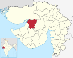
Morbi district | |
---|---|
Coordinates: 22°49′28.15846″N70°56′11.98194″E / 22.8244884611°N 70.9366616500°E | |
Country | India |
State | Gujarat |
Region | Saurashtra |
Headquarters | Morbi |
Area | |
• Total | 4,872 km2 (1,881 sq mi) |
Population (2011) | |
• Total | 960,329 |
• Density | 200/km2 (510/sq mi) |
Languages | |
• Official | Gujarati, Hindi |
Time zone | UTC+5:30 (IST) |
Vehicle registration | GJ-36 |
Website | morbi |
Morbi district is in the state of Gujarat, India. It was formed on 15 August 2013, along with several other districts, on the 67th Independence Day of India. [1] [2] Morbi city is the administrative headquarters of the district. The district has 5 talukas - Morbi, Maliya, Tankara, Wankaner (previously in Rajkot district) and Halvad (previously in Surendranagar district). Morbi city is the administrative headquarters of Morbi district. The town of Morbi is situated on the Machchhu River, 35 km from the sea and 60 km from Rajkot. As per 2011 census data, the city had a population of 2,10,451 and average literacy rate of 83.64%.
This district is surrounded by Kutch district to the north, Surendranagar district to the east, Rajkot district to the south and Jamnagar district to the west.
The district is named after Morbi city. The name of the city of Morbi (literally meaning the city of peacocks) was probably derived from the King of Bhuj.
The district was formed from 4 talukas formerly in Rajkot district (Morbi, Maliya, Tankara, Wankaner) and Halvad taluka, formerly in Surendranagar district.
Morbi district has an approx. population of 9,60,329, of which 358,420 (37.32%) lived in urban areas. Morbi district has an area of approx. 4,871.5 km2. and a density of 207 persons/sq km. The district had a sex ratio of 941 females per 1000 males. Scheduled Castes and Scheduled Tribes are 65,698 (6.84%) and 5,159 (0.54%) of the population respectively. [3] [4]
808,967 (84.24%) were Hindus, 143,925 (14.99%) were Muslims and 5,607 (0.58%) Jains. [5]
At the time of the 2011 census, 97.28% of the population spoke Gujarati, 0.96% Hindi and 0.90% Marathi as their first language. [6]
Morbi district consists of the following five talukas. [7]
Taluk | Number of villages | No. of Gram Panchayats |
---|---|---|
Morbi Taluk | 94 | 94 |
Tankara Taluk | 43 | 42 |
Halvad Taluk | 67 | 67 |
Wankaner Taluk | 102 | 101 |
Malia (Miana) Taluk | 44 | 44 |
District | No. | Constituency | Name | Party | Remarks | |
---|---|---|---|---|---|---|
Morbi | 65 | Morbi | Kantilal Amrutiya | Bharatiya Janata Party | ||
66 | Tankara | Durlabhbhai Dethariya | Bharatiya Janata Party | |||
67 | Wankaner | Jitendra Somani | Bharatiya Janata Party |
Morbi district is connected by national highway. It has two railway junctions, Wankaner and Maliya-Miyana. Morbi railway station lies on the track connecting these two junctions.
The Western Railway is one of the 19 zones of Indian Railways and is among the busiest railway networks in India, headquartered at Mumbai, Maharashtra. The major railway routes of Indian Railways which come under Western Railways are: Mumbai Central–Ratlam, Mumbai Central–Ahmedabad and Palanpur–Ahmedabad. The railway system is divided into six operating divisions: Ahmedabad, Vadodara, Rajkot, Bhavnagar, Ratlam, and Mumbai WR. Vadodara railway station, being the junction point for the Ahmedabad–Mumbai route and the Mumbai–Ratlam route towards New Delhi, is the busiest junction station in Western Railways and one of the busiest junctions of Indian Railways too, while Ahmedabad Division earns highest revenue followed by Mumbai Division and Vadodara Division. Surat railway station is one of the busiest railway station in Western Railway in non-junction category where more than 180 trains pass per day.
Amreli district is one of the 33 administrative districts of the state of Gujarat in western India. The district headquarters are located at Amreli. The district occupies an area of 6,760 km2 and has a population of 1,514,190 of which 22.45% were urban. Amreli is the land of Yogiji Maharaj (Dhari), Dan Bapu (Chalala), Sage Muldas, Sage Bhojalram Bapa, Sage Muktanand Swami, Magician K.Lal, Zaverchand Meghani's place (Bagasara), Dr. Jivaraj Mehta etc. Amreli covers Dhari Gir National forest sanctuary area. Now it is developing as a Hub of Education.
Narmada district is an administrative district in the state of Gujarat in India. The district headquarters are located at Rajpipla. The district is bounded by Vadodara and Chhota Udaipur districts in the north, by Nandurbar district of Maharashtra state in the east, by Surat and Tapi districts in the south and by Bharuch district in the west. The district occupies an area of 2,755 km2 and has a population of 590,297. It was 10.44% urban as of 2011. As of 2011, it is the third least populous district of Gujarat, after Dang and Porbandar.
Surendranagar is an administrative district in Saurashtra region of Gujarat state in India. It has a population of approximately 1.7 million people. Surendranagar, along with the twin city of Wadhwan, has a total of 400,000 inhabitants, and is known as "Camp".
Patan district is one of the 33 districts of Gujarat state in western India. Its main city is Patan. This district is located in northern Gujarat and bounded by Banaskantha district in the north and northeast, Mehsana district in the east and southeast, Surendranagar district in the south and Kutch District and the Kutch nu Nanu Ran in the west. The district occupies an area of 5792 km2.
Kheda District is one of the thirty-three districts of Gujarat state in western India. It is part of the region known as Charotar, consisting of Kheda and Anand districts. Its central city Nadiad is the administrative headquarters of the district.
Junagadh district is a district of the Indian state of Gujarat. Its administrative headquarters is the city of Junagadh.
Mehsana district is one of the 33 districts of Gujarat state in western India. Mehsana city is the administrative headquarters of this district. The district has a population of over 1.8 million and an area of over 4,500 km2. There are over 600 villages in this district with a population of 2,035,064 of which 22.40% were urban as of 2011.
Porbandar district is one of the 33 districts of Gujarat state in western India. The district covers an area of 2,316 km2. It had a population of 5.85,449 of which 48.77% were urban as of the 2011 census. This district was carved out of Junagadh district. It lies on the Kathiawar peninsula. Porbandar city is the administrative headquarters of this district. This district is surrounded by Jamnagar district and Devboomi Dwarka to the north, Junagadh district and Rajkot district to the east and the Arabian Sea to the west and south.
Rajkot district is one of the 33 districts of the Indian state of Gujarat. Located in Saurashtra peninsula, Rajkot city is the administrative headquarters of the district. It is the third-most advanced district in Gujarat and the fourth most populus.
Dhrangadhra is a town, taluka headquarters and a municipality in Surendranagar district in the state of Gujarat, India. During the period of the British Raj, the city was the capital of Dhrangadhra State, one of the eight first-class princely states of the Kathiawar Agency in the Bombay Presidency.
Veraval is a city and the headquarters of Gir Somnath district in the Indian state of Gujarat. Somnath temple, a place of pilgrimage due to its importance as Jyotirlinga site dedicated to Hindu deity Shiva, is located here. It is also known for the hub of fishing industries in India.
Rajkot Junction railway station is a railway station in the city of Rajkot, Gujarat. It is a major railway station in Saurashtra. It is connected to Wankaner Junction in north, Jamnagar in west and Jetalsar Junction in south. Many trains start from here.
Tapi district is one of the 33 districts of Gujarat state in western India. It has seven talukas: Vyara, Songadh, Nizar, Valod, Uchhal, Dolavan and Kukarmunda. Vyara town is the district headquarters. Tapi has 523 villages and two municipalities. The district was formed in 2007 out of some talukas that were separated from Surat district.
Botad District is a is a district in the state of Gujarat, India.
Devbhumi Dwarka District is a district of India located on the southern coast of the Gulf of Kutch in the state of Gujarat. Its headquarters are located in the city of Jamkhambhaliya. The district was created on 15 August 2013 from Jamnagar district.
Wankaner Junction railway station is located in Wankaner city of Morbi district, Gujarat. It is under Rajkot division of Western Railway. Its code is WKR. It has four platforms. Passenger, DEMU, Express, and Superfast trains halt here.
Gir Somnath is a district of Gujarat, India. It is located on the southern corner of the Kathiawar peninsula with its headquarters at the city of Somnath.
Tankara is one of the 182 Legislative Assembly constituencies of Gujarat state in India. It is part of Morbi district.
Malaniyad is a village located in the Halvad Taluka of Surendranagar district of Gujarat State, India. Now this village is in the Halvad taluka of Morbi district. of Gujarat state, India. New district is included in new Gujarat map. This village is near Little Rann of Kutch. Total Population of this village is around 3446.