
Saurashtra, also known as Kathiawar, is a peninsular region of Gujarat, India, located on the Arabian Sea coast. It covers about a third of Gujarat state, notably 11 districts of Gujarat, including Rajkot District. It was formerly a state of India before it merged with Bombay state. In 1961 it separated from Bombay and joined Gujarat.
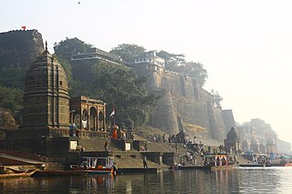
Maheshwar is a town, near Khargone city in Khargone district of Madhya Pradesh state, in central India. It is located on State Highway-38 ,13.5 km east of National Highway 3 and 91 km from Indore, the commercial capital of the state. The Town lies on the north bank of the Narmada River. It was the kingdom of Chaktavartin Samrat Sahastraarjun, Kartavirya Arjuna a Heheya king. Lately, after many years, it was the capital of the Malwa during the Maratha Holkar reign till 6 January 1818, when the capital was shifted to Indore by Malhar Rao Holkar III.

Dwarka is a town and municipality of Devbhumi Dwarka district in the state of Gujarat. It is located on the western shore of the Okhamandal Peninsula on the right bank of the Gomti river at the mouth of the Gulf of Kutch facing the Arabian Sea.
Bhavnagar is a city in the Bhavnagar district of the Saurashtra region of Gujarat, a state in India. It was founded in 1723 by Bhavsinhji Takhtasinhji Gohil (1703–1764). It was the capital of Bhavnagar State, which was a princely state before it was merged into the Indian Union in 1948. It is now the administrative headquarters of the Bhavnagar district.

Anjar is a town, township and municipality of the Kachchh district (Kutch)in the state of Gujarat, India. Founded in 650 AD, Anjar is a culturally diverse town of historic importance in the region. It is home to several historic religious temples, including the Jesal-Toral Shrines built in honour of a fourteenth century couple, whose lives inspired works of art and cinema. The town was devastated by several earthquakes, including the 1819 Rann of Kutch earthquake and 2001 Gujarat earthquake. In recent years, Anjar has become a hub of manufacturing activity.

Jamnagar is a city located on the western coast of India in the state of Gujarat of Saurashtra region. It is the administrative headquarters of the Jamnagar district and the fifth largest city in Gujarat. The city lies just to the south of the Gulf of Kutch, some 337 kilometres (209 mi) west of the state capital, Gandhinagar.
Mandvi is a beach town with municipality in the Kachchh district (Kutch) in the Indian state of Gujarat. It was once a major port of the region and summer retreat for Maharao (king) of the Cutch State. The old city was enclosed in the fort wall and remains of the fort wall can still be seen. The city has a four-hundred-year-old ship building industry which is still functional and dhows, a type of wooden ship, are still made. Mandvi Municipality's 36 Seat Of 9 Ward.

Surendranagar is an administrative district in Saurashtra region of Gujarat state in India. It has a population of approximately 1.7 million people. Surendranagar, along with the twin city of Wadhwan, has a total of 400,000 inhabitants, and is known as "Camp".
Beawar is a city in Beawar district of Indian state of Rajasthan. Beawar was the financial capital of Mewara state of Rajputana. As of 2011, the population of Beawar is 342,935. It is located 60 kilometres south from Ajmer, the divisional headquarter and 184 kilometres (114 mi) southwest of the state capital Jaipur, amidst Aravali hills. The city used to be a major center for trade, especially in raw cotton, and used to have cotton presses and the Krishna cotton mills. Currently, major industries include mineral-based units, machine-based units, machine tools and accessories, pre-stressed concrete pipes, plastic products, textiles, wooden furniture and asbestos cement pipes. Beawar is the largest producer of cement in northern India and home to Shree Cement. It is situated in a mineral-rich region having reserves of feldspar, quartz, asbestos, soapstone, magnesite, calcite, limestone, mica, emerald, granite, and masonry stone. Reserves of barytes, fluorite, wollastonite and vermiculite have also been found. Nearest airports are Jodhpur (145 km), Kishangarh and Jaipur (190 km). It is also connected by RSRTC operated buses to all parts of Rajasthan, and neighboring Delhi NCR, Ahmedabad (Gujarat), Gwalior. It also has railway connectivity with Delhi, Mumbai, Ahmadabad, Bangalore (bi-weekly), Haridwar, Dehradun (weekly), Bareilly and Muzzafarpur.
Prabhas Patan, also known as Somnath Patan, historically named Dev Patan, is locality situated in Veraval, Gir Somnath district in Saurashtra region of Gujarat, India. As the site of the Somnath temple and its associated Jyotirlinga, the town is an important place of Hindu pilgrimage.

Amreli is a city and a municipality in Amreli district in Indian state of Gujarat.

Gondal is a city of about 115,000 residents and a municipality of about 175,000 in the Rajkot district of the Indian state of Gujarat. Gondal Village was one of the eight first-class princely states of Kathiawar Agency, Bombay Presidency in British India. Ruled by a Hindu Rajput dynasty of the Jadeja.
Dhrangadhra is a town, taluka headquarters and a municipality in Surendranagar district in the state of Gujarat, India. During the period of the British Raj, the city was the capital of Dhrangadhra State, one of the eight first-class princely states of the Kathiawar Agency in the Bombay Presidency.
Jasdan is a city and a municipality in Rajkot district in the Indian state of Gujarat. Jasdan is the biggest sub district in the Rajkot district. Jasdan city has its own Municipality that is known as "Jasdan Municipality" JMP.
Rapar is a city and a municipality in Kutch district (Kachchh) in the Indian state of Gujarat.
Vadnagar is a town and municipality in the Mehsana district of the state of Gujarat in India. It is located 35 km (22 mi) from Mehsana. Its ancient names include Anartapura and Anandapura. It was a location visited by Xuanzang in 640 C.E. The founder and the first Director-General of the Archaeological Survey of India (ASI), Alexander Cunningham, had identified Anandapura with the town of Vadnagar. Vadnagar is also the birthplace of Narendra Modi, the current Prime Minister of India.
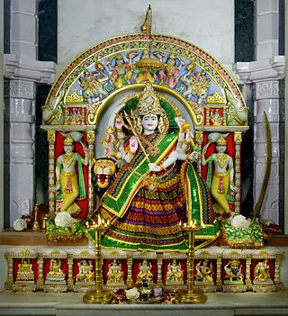
Ashapura Mata is an aspect of Devi, a Hindu goddess. She is one of the kuladevis of Kutch and Rajasthan, and the Jadeja clan of gujarat and Chauhans inhabiting the western indian provinces. She is a goddess regarded to fulfill the wishes of her adherents. In her iconography,

Morbi district is in the state of Gujarat, India. It was formed on August 15, 2013, along with several other districts, on the 67th Independence Day of India. Morbi city is the administrative headquarters of the district. The district has 5 talukas - Morbi, Maliya, Tankara, Wankaner and Halvad. Morbi city is the administrative headquarters of Morbi district. The town of Morbi is situated on the Machchhu River, 35 km from the sea and 60 km from Rajkot. As per 2011 census data, the city had a population of 2,10,451 and average literacy rate of 83.64%.
Simalwara is a census town in Dungarpur district in the Indian state of Rajasthan. It is the administrative headquarters for Simalwara Tehsil.

Kera is a village in Bhuj Taluka of Kutch district of Gujarat, India.this historical town was ruled by the jadeja's before independence in 1947. This historical town has several places of interest; the most important part of the town's history the Darbar gadh, the ruins of an old fort and Shiva temple, and the shrine of a Muslim saint Ghulam Ali.


