Gandhidham, initially known as Sardarganj, located in the eastern part of Kutch district, in the state of Gujarat. It is the largest and most populous city in (Kachchh) Kutch District, Gujarat, India.[1] It was created in the early 1950s for the resettlement of Sindhi Hindu refugees from Sindh, Pakistan, in the aftermath of the partition of India.[2] The city was named after M K Gandhi. An economic capital of Kutch, Gandhidham is a growing area for families and retirees. According to the 2011 Census, Gandhidham is Gujarat's 8th[3][4] most populous city. It is a popular destination for conventions, business, and meetings.
Soon after the Partition of India, in 1947, a large group of Sindhi Hindus refugees from Sindh of Pakistan migrated to India. The maharaja of Kutch Vijayaraji donated 15,000 acres (61km2) of land to Bhai Pratap, who founded the Sindhu Resettlement Corporation Ltd. (SRC) to rehabilitate Sindhi Hindus that migrated from Sindh in Pakistan.[5]
The Sindhu Resettlement Corporation Ltd was formed with Acharya Kriplani as chairman and Bhai Pratap Dialdas as managing director. The corporation's primary goal was to help displaced people find new dwellings by building a new township. The original plan was prepared by a team of planners headed by Otto H. Königsberger, director of the division of housing in the Government of India. Later, the plan was revised by Adams, Howard and Greeley Company in 1952. The foundation stone of the town was laid with the blessings of Mahatma Gandhi in 1947. Hence, the town was named Gandhidham. To clean the desert where it was built, Pratap gave an incentive of 25 paise to kill scorpions and 50 paise to kill snakes.[6] The original plan envisaged 400,000 as of the ultimate population of the town, expecting half of it to be reached in the mid-1970s. A revised plan envisaged three stages of town development with the mid-stage lasting longer with a population of around 150,000.
Geography and climate
Gandhidham is located at latitude 23.08° N longitude 70.13° E.[7] The main city is constructed in accordance with the principles of Vastu-Shastra (Hindu belief of construction), i.e., the main city has its face directed to the East.
Almost all rainfall occurs during the monsoon season from June to September — outside this period, Gandhidham averages just 15 millimetres or 0.59 inches of rain in eight months. Gandhidham's amount of rainfall, although not especially low on paper, is amongst the most erratic anywhere in the world with a coefficient of variation of around sixty percent [8] – among the few comparably variable climates in the world being the Line Islands of Kiribati, the Pilbara coast of Western Australia, the sertão of Northeastern Brazil, and the Cape Verde islands.[9]
During the "cool" season from October to March, temperatures range from very warm to hot during the afternoon and are cool to pleasant in the mornings. Whilst during the hot season, afternoon temperatures become sweltering and extremely unpleasant, especially when, with the approach of the monsoon, humidity increases.
The Gujarat earthquake of 2001 majorly affected the city of Gandhidham along with many nearby towns like Bhuj, Anjar, Bhachau and more. The shock, which measured 7.7 on the moment magnitude scale and had a maximum Mercalli intensity of XI (Extreme), killed 13,805–20,023, left roughly 166,800 injured, and many were left homeless including Gandhidham. The death toll in the Kutch region was 12,300. Bhuj, which was situated only 50 km away from the Gandhidham, was devastated. Considerable damage also occurred in City Gandhidham and Bhachau and Anjar with hundreds of villages flattened in Taluka of Anjar, Bhuj and Bhachau.
Land of Adipur and Gandhidham
Gandhidham was the dream of Pratap Dialdas. He requested great Leaders of India for the procurement of land in the Kachchh region. They requested Maharao Vijayraj Ji of Kachchh for granting of land for re-settlement of Sindhi community people migrated from Sindh. Maharao, without any delay, granted 15000 acres of land for the purpose. Bhai Pratap said this is too big land and cannot be developed by SRC Ltd, therefore, he desired to keep with him only 2,600 acres, and the rest of the land was given to KPT and GDA for management. Today Adipur and Gandhidham townships are the townships of pride in the District of Kachchh only with the grace of Rajput Kshatriya ancestors – Provided by Ram Amarnani.
Distance between twin-townships of Adipur & Gandhidham is 5 km developed fully . The airport road dividing wards 5 & 7 divides this city, whereas Municipality is one, known as Gandhidham Municipal Corporation (from 2023). These towns are divided in two parts wherein land is recognized as Wards & Sectors. They have six wards each 1 to 6 in Adipur and 7 to 12 in Gandhidham. These wards consist of commercial, industrial and residential plots of land. The land which is owned and managed by SRC (The Sindhu Resettlement Corporation Ltd) is known as 'Wards' and The land which is owned and managed by KPT (Kandla Port Trust) is known as 'Sectors'. There are 13 such sectors in Gandhidham. Apart from this, there is vast land managed by GDA (Gandhidham Development Authority) which is known as "NU". For the construction of any permanent structure in these townships, the permission of GDA is a must.
The Authority was constituted by the State Government under their Resolution No. TPS-3858(a) dated 08.08.1958 published in the Bombay Government Gazette part IVB, Extraordinary issue dated 11.08.1958. The GDA was created on 08.08.1958.[11]
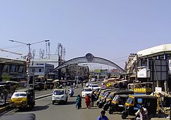
Rotary Circle
Tagore Road
Sri Gurunanak Dev ji Marg
Demographics
In 2011 the population of Gandhidham was 247,992, which consisted of 131,484 males and 116,508 females.[12]
Language
According to the 2011 Census, Gujarati speakers are a majority in Bhuj, followed by Hindi, Kachchhi, Sindhi and others.[13]
Colleges for graduation and higher studies are Tolani College of Science & Arts, Tolani Commerce College, Pharmacy college and Diploma in Engineering, Management Institute situated nearby in Adipur. DNV International Educational College is situated in Bharat Nagar; the courses provided are BCA and BBA. Gandhidham Institution of Medical Sciences (GIMS) has been started for aspiring Medical/ Pharmacy students/
Transport
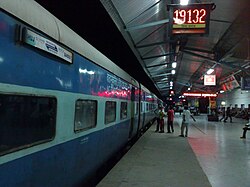
Gandhidham Junction main entranceKutch Express at Gandhidham Railway Station(Gandhidham - Kamakhya) Express route map
The area is served by Kandla airport near Galpadar town. Daily service is available to Mumbai. SpiceJet announced one more flight for Mumbai from 11 July 2017 onward.
↑ "Bhai Pratap". The Sindhu Resettlement Corporation, Gandhidham, India. p.1. Archived from the original on 17 December 2009. Retrieved 28 September 2007. To clean the desert where it was built, Bhai Pratap gave an incentive of 25 paise to kill scorpions and 50 paise to kill snakes
↑ Van Etten, Eddie J.B.; ‘Inter-annual Rainfall Variability of Arid Australia: greater than elsewhere?’; Australian Geographer; 40 (2009), pp. 109-120
↑ Dewar, Robert E. and Wallis, James R; ‘Geographical patterning of interannual rainfall variability in the tropics and near tropics: An L-moments approach’; in Journal of Climate, 12; pp. 3457-3466
↑ "Census of India". The Registrar General & Census Commissioner, India, New Delhi, Ministry of Home Affairs, Government of India. 26 June 2007. Retrieved 3 September 2015.
Kripalani, J. B. 1951. Gandhidham. Bombay: [Mangharam N. Thadani for the Sindhu Resettlement Corp.]
Adams, Howard & Greely. 1952. Report on a revised plan for the town and region of Gandhidham, Anjar Taluka, Kutch India, prepared for the Government of India Ministry of Transport, and the United States Department of State. [Boston: Adams, Howard & Greely].
This page is based on this Wikipedia article Text is available under the CC BY-SA 4.0 license; additional terms may apply. Images, videos and audio are available under their respective licenses.