Districts of Andhra Pradesh | |
---|---|
![]() Andhra Pradesh Political Map | |
Category | Districts |
Location | Andhra Pradesh |
Number | 26 districts |
Populations | Parvathipuram Manyam – 9,25,340 (lowest); Nellore – 24,69,712 (highest) |
Areas | Visakhapatnam – 1,048 km2 (405 sq mi) (smallest); Prakasam – 14,322 km2 (5,530 sq mi) (largest) |
Government | |
Subdivisions |
The state of Andhra Pradesh has 26 districts. Visakhapatnam district is the smallest district in area while Prakasam district is the largest. Nellore district is the most populous whereas Parvathipuram Manyam district is the least populous district. The districts are further divided into two or more revenue divisions, which are further subdivided into mandals for administrative purposes.
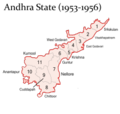
At the time of Independence the present day Andhra Pradesh was a part of the Madras State. The telugu speaking dominant regions Kostaandhra and Rayalaseema were separated from Madras State to form Andhra State in 1953. [1]
As Andhra State, it consists of 11 districts, which are Anantapur, Chittoor, East Godavari, Guntur, Kadapa, Krishna, Kurnool, Nellore, Srikakulam, Visakhapatnam and West Godavari. [2] [3]
As a result of the 1956 States Reorganisation Act, the state's boundaries were re-organized following linguistic lines. On 1 November 1956, the Andhra State and the Telangana region of the Hyderabad State were merged to form the Andhra Pradesh which is retrospectively referred to as United Andhra Pradesh.
As united Andhra Pradesh, it consisted of 21 districts, with 10 districts of Telangana region.[ citation needed ] In the year 1959, Bhadrachalam and Nuguru Venkatapuram taluks of East Godavari district, which are on the other side of the Godavari River, were merged into Khammam district on grounds of geographical contiguity and administrative viability. Similarly Aswaraopeta part of West Godavari District was added to Khammam district and Munagala taluk belonging to Krishna district was added to Nalgonda district in the same year. [4]
The number of districts became 23 with the formation of Prakasam district from the parts of Guntur, Nellore and Kurnool districts in 1970 and Vizianagaram district from parts of Visakhapatnam and Srikakulam districts in 1979.
After the bifurcation of the United Andhra Pradesh in 2014, the Andhra region now known as Andhra Pradesh was left with 13 districts but was given several tribal-dominated mandals from the Khammam district of the Telangana as part of the Polavaram project. These mandals were added to the East Godavari and West Godavari district's respectively. [5] [6] [7] [8]
On 26 January 2022, the Government of Andhra Pradesh proposed 13 new districts by issuing a draft notification under the Andhra Pradesh Districts (Formation) Act, 1974, Section 3(5). [9] [10] After taking the objections and suggestions received from the public into consideration, the government has published the final notification on 3 April 2022. With effect from 4 April 2022 the newly formed districts came into effect as specified in the schedule. [11] [12] [13] At present there are 26 districts spread across 3 cultural regions: Uttaraandhra, Kostaandhra and Rayalaseema.
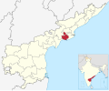
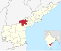
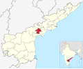
The state is further divided into 26 districts, with North Andhra comprising six districts, Coastal Andhra comprising 12 districts, and Rayalaseema comprising eight districts. [14] These districts are made up of 76 revenue divisions, [15] 679 mandals [15] and 13,324 village panchayats as part of the administrative organisation. [16]
North Andhra:
Coastal Andhra:
Rayalaseema:
S.No | Code [17] | Official name | Headquarters | Past District | Revenue divisions | Mandals | Population | Area (in sq.km) | Density (per sq.km) | Map |
---|---|---|---|---|---|---|---|---|---|---|
1 | SRI | Srikakulam | Srikakulam | 3 | 30 | 21,91,471 | 4,591 | 477.34 | ![]() | |
2 | PAR | Parvathipuram Manyam | Parvathipuram | Srikakulam, Vizianagaram. | 2 | 15 | 9,25,340 | 3,659 | 252.89 | ![]() |
3 | VIZ | Vizianagaram | Vizianagaram | 3 | 27 | 19,30,811 | 4,122 | 468.42 | ![]() | |
4 | VIS | Visakhapatnam | Visakhapatnam | 2 | 11 | 19,59,544 | 1,048 | 1869.79 | ![]() | |
5 | ALL | Alluri Sitharama Raju | Paderu | East Godavari, Visakhapatnam, Vizianagaram. | 3 | 22 | 9,53,960 | 12,251 | 77.87 | ![]() |
6 | ANA | Anakapalli | Anakapalli | Visakhapatnam | 2 | 25 | 17,26,998 | 4,292 | 402.38 | ![]() |
7 | KAK | Kakinada | Kakinada | East Godavari | 2 | 21 | 20,92,374 | 3,019 | 693.07 | ![]() |
8 | EAS | East Godavari | Rajamahendravaram | 2 | 19 | 18,32,332 | 2,561 | 715.48 | ![]() | |
9 | KON | Dr. B. R. Ambedkar Konaseema | Amalapuram | East Godavari | 3 | 22 | 17,19,093 | 2,083 | 825.30 | ![]() |
10 | ELU | Eluru | Eluru | West Godavari | 3 | 27 | 20,06,737 | 6,579 | 305.02 | ![]() |
11 | WES | West Godavari | Bhimavaram | 3 | 20 | 18,44,898 | 2,278 | 809.88 | ![]() | |
12 | NTR | NTR | Vijayawada | Krishna | 3 | 20 | 22,18,591 | 3,316 | 669.06 | ![]() |
13 | KRI | Krishna | Machilipatnam | 3 | 26 | 17,35,079 | 3,775 | 459.62 | ![]() | |
14 | PAL | Palnadu | Narasaraopeta | Guntur | 3 | 28 | 20,41,723 | 7,298 | 279.76 | ![]() |
15 | GUN | Guntur | Guntur | 2 | 18 | 20,91,075 | 2,443 | 855.95 | ![]() | |
16 | BAP | Bapatla | Bapatla | Guntur Prakasam | 3 | 25 | 15,86,918 | 3,829 | 414.45 | ![]() |
17 | NEL | Sri Potti Sriramulu Nellore | Nellore | 4 | 38 | 24,69,712 | 10,441 | 236.54 | ![]() | |
18 | PRA | Prakasam | Ongole | 3 | 39 | 22,88,026 | 14,322 | 159.76 | ![]() | |
19 | KUR | Kurnool | Kurnool | 3 | 26 | 22,71,686 | 7,980 | 284.67 | ![]() | |
20 | NAN | Nandyal | Nandyal | Kurnool | 3 | 30 | 17,81,777 | 9,682 | 184.03 | ![]() |
21 | ANA | Anantapuramu | Anantapuram | 3 | 32 | 22,41,105 | 10,205 | 219.61 | ![]() | |
22 | SSS | Sri Sathya Sai | Puttaparthi | Anantapuramu | 4 | 32 | 18,40,043 | 8,925 | 206.17 | ![]() |
23 | CUD | YSR | Kadapa | 4 | 36 | 20,60,654 | 11,228 | 183.53 | ![]() | |
24 | ANN | Annamayya | Rayachoti | Chittoor, YSR | 3 | 30 | 16,97,308 | 7,954 | 213.39 | ![]() |
25 | TIR | Tirupati | Tirupati | Chittoor, Nellore | 4 | 34 | 21,96,984 | 8,231 | 266.92 | ![]() |
26 | CHI | Chittoor | Chittoor | 4 | 32 | 18,72,951 | 6,855 | 273.22 | ![]() |
Coastal Andhra, also known as Kosta Andhra, is a geographic region in the Indian state of Andhra Pradesh, comprising the coastal districts of the state between the Eastern Ghats and the Bay of Bengal, from the northern border with Orissa to Rayalaseema in the south. It includes major cities such as Visakhapatnam and Vijayawada as well as the state capital Amaravati and is recognized for its fertile lands, rich cultural heritage, and economic importance. Coastal Andhra plays a significant role in the state's agricultural output, particularly in rice and tobacco production, supported by abundant water resources from the Godavari, Krishna, and Penna rivers.
Rayalaseema is a geographic region in the Indian state of Andhra Pradesh. It comprises four southern districts of the State, from prior to the districts reorganisation in 2022, namely Kurnool, Anantapur, YSR, and Chittoor. Four new districts were created from these, namely Sri Sathya Sai, Nandyal, Annamayya, and Tirupati. As of 2011 census of India, the western four districts of the region had a population of 15,184,908 and cover an area of 77,424 km2 (29,894 sq mi).
Andhra State was a state in India created in 1953 from the Telugu-speaking northern districts of Madras State. The state was made up of this two distinct cultural regions – Rayalaseema and Coastal Andhra. Andhra State did not include all Telugu-speaking areas, as it excluded some in Hyderabad State. Under the State Reorganisation Act of 1956, Andhra State was merged with the Telugu-speaking regions of Hyderabad State to form Andhra Pradesh.
Andhra Pradesh State Road Transport Corporation, officially Andhra Pradesh Raastra Roadu Ravaana Samstha, is the state-owned road transport corporation in the Indian state of Andhra Pradesh. Its headquarters is located at NTR Administrative Block of RTC House in Pandit Nehru bus station of Vijayawada. Many other Indian metros & towns in Telangana, Tamil Nadu, Karnataka, Odisha and Chhattisgarh are also linked with the APSRTC services.
The recorded history of Andhra Pradesh, one of the 28 states of 21st-century India, begins in the Vedic period. It is mentioned in Sanskrit epics such as the Aitareya Brahmana. Its sixth-century BCE incarnation Assaka lay between the Godavari and Krishna Rivers, one of sixteen mahajanapadas. The Satavahanas succeeded them, built Amaravati, and reached a zenith under Gautamiputra Satakarni.
Andhra Pradesh is a state in India. Andhra Pradesh Tourism Development Corporation (APTDC) is a state government agency which promotes tourism in Andhra Pradesh, describing the state as the Koh-i-Noor of India. Andhra Pradesh has a variety of tourist attractions including beaches, hills, caves, wildlife, forests and temples.
Andhra Pradesh lies between 12°41' and 19.07°N latitude and 77° and 84°40'E longitude, and is bordered by Telangana to the north and west, Chhattisgarh to the north-west, Orissa to the north, the Bay of Bengal to the east, Tamil Nadu to the south and Karnataka to the southwest and west. Andhra Pradesh has a coastline of around 974 km, which gives it the second longest coastline in the nation. Two major rivers, the Godavari and the Krishna run across the state. A small enclave 12 sq mi (30 km²), the Yanam district of Puducherry, lies in the Godavari Delta in the north east of the state. The state includes the eastern part of Deccan plateau as well as a considerable part of the Eastern Ghats.
The Polavaram Project is an under construction multi-purpose irrigation project on the Godavari River in the Eluru District and East Godavari District in Andhra Pradesh. The project has been accorded National project status by the Central Government of India. Its reservoir back water spreads up to the Dummugudem Anicut and approx 115 km on Sabari River side. Thus back water spreads into parts of Chhattisgarh and Odisha States. It gives major boost to tourism sector in Godavari Districts as the reservoir covers the famous Papikonda National Park, Polavaram hydro electric project (HEP) and National Waterway 4 are under construction on left side of the river. It is located 40 km to the upstream of Sir Arthur Cotton Barrage in Rajamahendravaram City and 25 km from Rajahmundry Airport.
Relli is a social group of South Indians who reside in the states of Andhra Pradesh, Odisha, West Bengal, and Chhattisgarh. They are classified as a Scheduled Caste.
Chowdavaram may refer to:
The coastline of Andhra Pradesh is located on the southeastern coast of the Indian Peninsula in the Bay of Bengal and is part of the Northern Circars. With a length of 975 km, it has the second longest coastline in India after Gujarat. The coastal corridor boasts several ports, harbors, vast stretches of sandy beaches, wildlife and bird sanctuaries, as well as fresh water lakes and estuaries.
The following outline is provided as an overview of and topical guide to Andhra Pradesh:
Eluru district is a district in coastal Andhra Region in the Indian state of Andhra Pradesh. With Eluru as its administrative headquarters, it was proposed on 26 January 2022 to become one of the resultant twenty six districts in the state once a final notification is issued by the government of Andhra Pradesh. It is formed from Eluru revenue division and Jangareddygudem revenue division from West Godavari district and Nuzvid revenue division from Krishna district.
Parvathipuram Manyam district is a district in the Indian state of Andhra Pradesh. With Parvathipuram as its administrative headquarters, it became functional from 4 April 2022. The district was formed from Parvathipuram revenue division from Vizianagaram district and part of Palakonda revenue division of Srikakulam district. The district was once part of ancient Kalinga. The famous Kamalingeswara swamy temple was built in the regin of King Rajaraja Deva of Eastern Ganga Dynasty of Odisha in 11th century CE.