Anantapur

Last updated

Anantapur
Anantapuramu
Anantapur Clock tower at night.jpg
Clock tower at Anantapur
Anantapur
Interactive map
India Andhra Pradesh location map (current).svg
Red pog.svg
Anantapur
India location map.svg
Red pog.svg
Anantapur
Asia laea location map.svg
Red pog.svg
Anantapur
Coordinates: 14°40′48″N77°35′56″E / 14.68°N 77.599°E / 14.68; 77.599
CountryFlag of India.svg  India
State Andhra Pradesh
District Anantapuramu
Government
  Body Anantapur Municipal Corporation, Anantapur–Hindupur Urban Development Authority
Area
  Total105.98 km2 (40.92 sq mi)
Elevation
335 m (1,099 ft)
Population
 (2011)
  Total340,613
  Rank[126th] in India ,[10th] in Andhra Pradesh
  Density3,200/km2 (8,300/sq mi)
Languages
  Official Telugu
Time zone UTC+5:30 (IST)
PIN
515001, [3] 515002, 515003, 515004, 515005 [4] 515281, [5] 515731 [6] and Complete Anantapur Pincode List [7]
Telephone code08554
Vehicle registration AP-02
Website anantapur.cdma.ap.gov.in

Anantapur, officially Anantapuramu, [8] is a city in Anantapur district of the Indian state of Andhra Pradesh. It is the mandal headquarters of Anantapuru mandal and also the divisional headquarters of Anantapur revenue division. [9] The city is located on National Highway. It was also the headquarters of the Datta Mandalam (Rayalaseema districts of Andhra Pradesh and Bellary district of Karnataka) in 1799. It was also a position of strategic importance for the British Indian Army during the Second World War.

Contents

Geography

Anantapur is located at 14°41′N77°36′E / 14.68°N 77.6°E / 14.68; 77.6 . [10] It has an average elevation of 335 m (1,099 ft). It is located at a distance of 484 km from Vijayawada, 148 km from Kurnool and 210 km from Bengaluru which is the closest international airport.

Climate

Anantapur has a semi-arid climate, with hot and dry conditions for most of the year. Summer start in late February and peak in May with average high temperatures around the 37 °C (99 °F) range. Anantapur gets pre-monsoon showers starting as early as March, mainly through north-easterly winds blowing in from Kerala. Monsoon arrives in September and lasts until early November with about 250 mm (9.8 in) of precipitation. A dry and mild winter starts in late November and lasts until early February; with little humidity and average temperatures in the 22–23 °C (72–73 °F) range. Total annual rainfall is about 22 in (560 mm).

Climate data for Anantapuram (1981–2010, extremes 1946–present)
MonthJanFebMarAprMayJunJulAugSepOctNovDecYear
Record high °C (°F)36.1
(97.0)
39.4
(102.9)
41.8
(107.2)
43.2
(109.8)
44.1
(111.4)
43.1
(109.6)
38.8
(101.8)
38.9
(102.0)
37.9
(100.2)
37.8
(100.0)
36.8
(98.2)
33.8
(92.8)
44.1
(111.4)
Mean daily maximum °C (°F)31.0
(87.8)
34.3
(93.7)
37.6
(99.7)
39.4
(102.9)
39.2
(102.6)
35.7
(96.3)
33.8
(92.8)
33.0
(91.4)
33.1
(91.6)
31.9
(89.4)
30.3
(86.5)
29.6
(85.3)
34.1
(93.4)
Mean daily minimum °C (°F)17.5
(63.5)
19.4
(66.9)
22.7
(72.9)
25.8
(78.4)
26.2
(79.2)
25.0
(77.0)
24.3
(75.7)
23.9
(75.0)
23.4
(74.1)
22.5
(72.5)
20.1
(68.2)
17.7
(63.9)
22.4
(72.3)
Record low °C (°F)9.0
(48.2)
10.4
(50.7)
13.4
(56.1)
18.3
(64.9)
18.8
(65.8)
19.6
(67.3)
19.6
(67.3)
19.9
(67.8)
19.3
(66.7)
14.1
(57.4)
10.0
(50.0)
9.4
(48.9)
9.0
(48.2)
Average rainfall mm (inches)1.3
(0.05)
0.4
(0.02)
9.4
(0.37)
18.9
(0.74)
53.0
(2.09)
59.9
(2.36)
66.0
(2.60)
91.3
(3.59)
133.6
(5.26)
95.5
(3.76)
38.7
(1.52)
9.1
(0.36)
577.2
(22.72)
Average rainy days0.10.20.41.32.93.24.65.36.96.43.00.634.9
Average relative humidity (%) (at 17:30 IST)37282625314651545557544843
Source: India Meteorological Department [11] [12] [13]

Demographics

As of 2011 census, Anantapur city has a population of 340,613. The sex ratio was 995 females per 1000 males and 9% of the population was under 6 years old. [14] Effective literacy is 82%, male literacy is 89% and female literacy is 75%. Telugu is the official and widely spoken language, in addition to it Urdu, Hindi, Kannada and Tamil languages are also spoken by significant minorities in the city. [15]

Governance

Civic administration

Anantapuru Municipal Corporation is the civic body of Anantapuru.

Public utilities

Anantapuru Drinking Water Supply Project and Sri Sathya Sai Central Trust have also step forward in supplying clean water and concentrated mainly on eradicating fluorosis. [16] The corporation supplies chlorinated water to the city from the summer storage tank located in the town. [17]

Transport

Saptagiri Circle Sapatgiri Circle.jpg
Saptagiri Circle

Anantapur is well connected to the nearby major cities with National Highway 44 and National Highway 205 of National Highway network of India. The NH–44 connects it to Bangalore, which is towards south and Hyderabad, towards north, and NH 205 connects it to Chennai via Renigunta. [18] The Andhra Pradesh State Road Transport Corporation operates bus services from Anantapur bus station. [19] The city has a total road length of 298.12 km. [20]

Anantapuram provides rail connectivity for the city and is classified as an A–category station in Guntakal railway division of South Central Railway zone. The nearest International airport is Kempegowda International Airport, Bengaluru which is 190 kilometers away.

Culture

There are a few notable people from the town with their contributions to various fields such as politics, film industry and other areas. Neelam Sanjiva Reddy was the former President of India and the first Chief Minister of Andhra Pradesh, and Paidi Lakshmayya was the first member of Parliament from Anantapur's Lok Sabha Constituency. Kallur Subba Rao was an Indian freedom activist and was the first speaker of Andhra Assembly, as well as Kadiri Venkata Reddy, who was an Indian film director, writer and also a producer. Sathya Sai Baba, was a Hindu spiritual leader; Bellary Raghava was an Indian playwright, thespian and film actor.

Cuisine

Millets such as, Jowar, Bajra, Ragi are the food grains which are mostly used in food items. Peanuts are also popular and used in everyday food like chutney, Chikki and enjoyed as snack with boiled or spicy roasted peanuts. [21]

Cityscape

ISKCON temple, Anantapur Ananthapur ISKCON.jpg
ISKCON temple, Anantapur

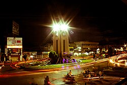
Neighbourhoods and landmarks in and around the city are - Clock tower, Sapthagiri circle, ISKCON temple, [22] the railway station area, bus station, Srikantam circle, Government Hospital, Court Road etc. Major landmark of city is railway overbridge near Clock tower connecting Newtown constructed in late 1960. [23] As part of connecting heart of city with NH44 this landmark is in demolition and closed till new four-lane flyover is functional. [24]

Education

The primary and secondary education is imparted by government, aided and private schools of the School Education Department of the state. [25] [26] The mediums of instruction that are followed by different CBSE schools like Kendriya Vidyalaya and Montessori Elite EM School, State board English mediums and Telugu mediums.


Anantapur is an important education centre of the district which has many schools, colleges and universities. Prominent institutions and universities include, Sri Krishnadevaraya University, JNTU Anantapur, Sri Sathya Sai University, central University of Andhra Pradesh, Government Medical College, Arts College, PVKK Institute of Technology, Central university of Andhra Pradesh[CUAP] etc.

Sports

Anantapur has many sports facilities and hosted the Irani Cup in 1963–64 when Rest of India scored their lowest total of 83 against the then Ranji trophy winners Bombay, played at the Sanjeeva Reddy stadium. Several Ranji trophy matches and other regional tournaments for basketball, badminton, etc. have been hosted in Anantapur.

The Anantapur Sports Village (ASV), located alongside the National Highway 7. The Anantapur Cricket Ground sits within a 40-acre (160,000 m2) complex which is managed by the Rural Development Trust (RDT). [27] In October 2010, Rafael Nadal opened the Rafael Nadal Tennis School, which hosts district, state and national-level tournaments, as well as laying equal emphasis on the children's education and tennis training. There are several Indoor Stadiums for Basketball and Badminton under local bodies which conducts District, State and National Competitions. There are many coaching class for taekwondo and Karate. There are also coaching centres for swimming which conduct district competitions. [28] [29]

Temples

There are four temples under the management of Endowments Department. [30]

And there are several important Temples which became good landmarks such as

Hospitals

See also

Related Research Articles

<span class="mw-page-title-main">Mangalagiri</span> Municipal Corporation in Andhra Pradesh, India

Mangalagiri is a major Sub-urban of Vijayawada in Guntur district of Indian state of Andhra Pradesh. The town is a part of Mangalagiri Tadepalli Municipal Corporation and part of Tenali revenue division. It and a part of Andhra Pradesh Capital Region. It is situated on National Highway 16 between Vijayawada and Guntur.

<span class="mw-page-title-main">Chittoor</span> City in Andhra Pradesh, India

Chittoor is a city and district headquarters in Chittoor district of the Indian state of Andhra Pradesh. It is also the mandal and divisional headquarters of Chittoor mandal and Chittoor revenue division respectively. The city has a population of 153,756 and that of the agglomeration is 175,647.

<span class="mw-page-title-main">Rayalaseema</span> Geographic region of Andhra Pradesh in India

Rayalaseema is a geographic region in the Indian state of Andhra Pradesh. It comprises four southern districts of the State, from prior to the districts reorganisation in 2022, namely Kurnool, Anantapur, YSR and Chittoor. Four new districts were created from these, namely Sri Sathya Sai, Nandyal, Annamayya and Tirupati. As of 2011 census of India, the western four districts of the region had a population of 15,184,908 and cover an area of 71,060 km2 (27,440 sq mi).

<span class="mw-page-title-main">Kalyandurg</span> Town in Andhra Pradesh, India

Kalyandurg is a town in Anantapur district of the Indian state of Andhra Pradesh. It is the headquarters for Kalyandurg mandal and Kalyandurg revenue division. The discovery of diamond-bearing Kimberlites in Kalyandurg area, is one of the clusters that has been discovered.

Dharmavaram is a city in Sri Sathya Sai District of the Andhra Pradesh state of Indian country. It is mandal and divisional headquarters of Dharmavaram mandal and Dharmavaram revenue division respectively. The city is known for its handloom silk sarees. The city is renowned for cotton, silk weaving industries and leather puppets. The city is called as Silk city of Andhra Pradesh. Dharmavaram is famous for Handloom Weavers, Saree Designs, Jacquard designs, Silk Extraction from Silkworm Cacoons, Dyeing and it is fully populated by maximum weavers and by developing technology makes changes by producing various types of machine equipment emerging for weavers to weave quickly than the past decades and quality production was happening now and the production was famous for Sarees.

Gudivada is a city in Krishna district of the Indian state of Andhra Pradesh. It is a municipality and the headquarters of Gudivada mandal in Gudivada revenue division. It is one of the cities in the state to be a part of Andhra Pradesh Capital Region. It is the twenty-seventh most populous city in Andhra Pradesh and the three-hundredth most populous city in India with a population of 118,167 according to the 2011 Census of India.

<span class="mw-page-title-main">Gooty</span> Town in Andhra Pradesh, India

Gooty is a town in Anantapur district of the Indian state of Andhra Pradesh. It is the headquarters of Gooty mandal in Anantapur revenue division. The town is renowned for the Gooty hill fort.

<span class="mw-page-title-main">Tirupati</span> City in Andhra Pradesh, India

Tirupati is a city in the Indian state of Andhra Pradesh. It is the administrative headquarters of the Tirupati district. The city is home to the important Hindu shrine of Tirumala Venkateshwara Temple and other historic temples. It is located at a distance of 150 km from Chennai, 250 km from Bangalore, 406 km from Amaravati. It is one of the eight Svayam vyakta kshetras dedicated to Vishnu. Tirupati is a municipal corporation and the headquarters of Tirupati (urban) mandal, Tirupati (rural) mandal, and the Tirupati revenue division.

<span class="mw-page-title-main">Anantapur district</span> District of Andhra Pradesh in India

Anantapur district, officially Anantapuramu district, is one of the eight districts in the Rayalaseema region of the Indian state of Andhra Pradesh. The district headquarters is located in Anantapur city. It is one of the driest places in South India. In the year 2022, as part of re-organisation of districts, Sri Sathya Sai district was carved out.

Rajampeta is a Municipality in Annamayya district of the Indian state of Andhra Pradesh, located in the Rayalaseema Region formed on the banks of Cheyyeru River. The town has an average elevation of 139 meters (456 ft). Rajampet is a Grade II Municipality which upgraded in 2019 and has an area of 35.38 square kilometres (13.66 sq mi). It consists of 29 election wards.

Guntakal is a City in Anantapur district of the Indian state of Andhra Pradesh. It is the headquarters of Guntakal mandal and Guntakal revenue division.It is also the headquarters of the Guntakal Railway Division in South Central Railway.

Kadiri is a major city in Sri Sathya Sai District the Indian state of Andhra Pradesh. It is a Special Grade Municipal City Council and headquarters of Kadiri Mandal and Kadiri Revenue Division. Kadiri Taluka ('Tehsil') was the largest taluk in the state of Andhra Pradesh when there was taluka system in Andhra Pradesh Kadiri is known for its jasmine and saffron flowers. Kadiri saffron is widely sold in Andhra and Karnataka. The Sri Lakshmi Narasimhaswamy Temple is reminiscent of Kadiri to the people of Karnataka, Telangana And Tamil Nadu. The name of Kadiri has also some interesting past. The habitation was initially named as Khadripuram as ‘khadara’ plants were largely found in the surrounding forests and Khadri has later transformed as Kadiri.

<span class="mw-page-title-main">Hindupur</span> City in Andhra Pradesh, India

Hindupuram is a city in Sri Sathya Sai district of the Indian state of Andhra Pradesh. It is located to the edge of the Andhra–Karnataka border and is the headquarters of Hindupuram mandalam. Hindupuram is the Parliamentary Constituency in the newly formed District Sri Sathya Sai. It is located about 67 km from district headquarters Puttaparthi, 100 km from Bengaluru the capital of Karnataka, 95 km From Kadiri.

<span class="mw-page-title-main">Tadipatri</span> City in Andhra Pradesh, India

Tadipatri or Tadpatri is a city in Anantapur district of the Indian state of Andhra Pradesh at the border of Kurnool district and Kadapa district. It is the mandal headquarters of Tadipatri mandal in Anantapur revenue division. The Chintala Venkataramana Temple is located on a five-acre site in Tadipatri. The Bugga Ramalingeswara Temple is located one kilometer from the town, overlooking the Penna River.

Somandepalle is a census town in Sri Sathya Sai district of the Indian state of Andhra Pradesh. It is located in Somandepalle mandal of Penukonda revenue division. The town is a constituent of Anantapur urban agglomeration.

<span class="mw-page-title-main">Mounagiri Hanuman Temple</span> Hindu temple in India

Mounagiri is a Hindu temple near Bengaluru Highway in Anantapur, India. The temple displays millennia of traditional Hindu and Andhra culture, spirituality, and architecture. The temple was inspired and developed by Sri Eswaraiah Swamy, the spiritual head of the Mounagiri Global Trust and Philosophical Society, whose 500 volunteers helped 1,000 artisans construct the Mounagiri Hanuman Temple. The Hanuman idol cost around 40 lakh (US$50,000) to sculpture.

<span class="mw-page-title-main">Sri Sunama Jakini Matha</span> Hindu temple in India

Sri Sunama Jakini Maatha was born in Suryavamshi Kshatriya Are-Katika community of Pinnepalli village in Anantapur district, Andhra Pradesh, India. A temple was built for this goddess in Gooty town of Anantapur district, Andhra Pradesh is also one of the first temple for Suryavamshi Kshatriya Are-katika community.

The Anantapuramu–Hindupur Urban Development Authority (AHUDA) is an urban planning agency in Anantapur district of the Indian state of Andhra Pradesh. It was constituted on 4 November 2017, under Andhra Pradesh Metropolitan Region and Urban Development Authority Act, 2016 with the headquarters located at Anantapuramu.

<span class="mw-page-title-main">Sri Sathya Sai district</span> District in Andhra Pradesh, India

Sri Sathya Sai district is a district in the Indian state of Andhra Pradesh. Its headquarters is at Puttaparthi. It was formed on 4 April 2022 from parts of the erstwhile Anantapur district.

References

  1. "Municipalities, Municipal Corporations and UDAs" (PDF). Directorate of Town and Country Planning. Government of Andhra Pradesh. Retrieved 23 June 2016.
  2. "Statistical Abstract of Andhra Pradesh, 2015" (PDF). Directorate of Economics & Statistics. Government of Andhra Pradesh. p. 46. Archived from the original (PDF) on 14 July 2019. Retrieved 27 April 2019.
  3. Ramachandra-nagar
  4. Alamuru
  5. ,,Aladahalli
  6. Akuledu
  7. Anantapur Pin Code List
  8. "About Anantapuramu Municipal Corporation | Anantapuramu Municipal Corporation". anantapur.cdma.ap.gov.in. Archived from the original on 3 June 2017. Retrieved 10 June 2017.
  9. "anantapuramu District Mandals" (PDF). Census of India. pp. 395, 435. Retrieved 19 January 2015.
  10. Falling Rain Genomics, Inc – Anantapuramu. Fallingrain.com. Retrieved on 3 September 2013.
  11. "Station: Anantapur Climatological Table 1981–2010" (PDF). Climatological Normals 1981–2010. India Meteorological Department. January 2015. pp. 47–48. Archived from the original (PDF) on 5 February 2020. Retrieved 10 February 2020.
  12. "Extremes of Temperature & Rainfall for Indian Stations (Up to 2012)" (PDF). India Meteorological Department. December 2016. p. M5. Archived from the original (PDF) on 5 February 2020. Retrieved 10 February 2020.
  13. "Anantapur Climatological Table 1981–2010". India Meteorological Department. Retrieved 10 February 2020.
  14. "Provisional Population Totals, Census of India 2011; Cities having population 1 lakh and above" (PDF). Office of the Registrar General & Census Commissioner, India. Retrieved 26 March 2012.
  15. "Census Digital Library". Open Government Data (OGD) Platform India. Retrieved 13 February 2017.
  16. "Anantapur Drinking Water Supply Project Anantapur Drinking Water Supply Project". Srisathyasai.org.in. Archived from the original on 4 March 2016. Retrieved 27 February 2016.
  17. "Commissioner inspects summer storage tanks". The Hans India. Anantapur. 15 May 2009. Archived from the original on 4 August 2020. Retrieved 27 February 2016.
  18. "NH wise Details of NH in respect of Stretches entrusted to NHAI" (PDF). National Highways Authority of India (NHAI). Archived from the original (PDF) on 25 February 2009. Retrieved 4 July 2008.
  19. "Bus Stations in Districts". Andhra Pradesh State Road Transport Corporation. Archived from the original on 22 March 2016. Retrieved 9 March 2016.
  20. "DETAILS OF ROADS IN EACH ULB OF ANDHRA PRADESH". Archived from the original on 1 August 2016. Retrieved 4 October 2016.
  21. Sarma, G. v Prasada (18 June 2016). "Plan to encourage millet consumption". The Hindu. Archived from the original on 4 August 2020. Retrieved 14 October 2016.
  22. "ISKCON Temple ISKCON Temple". Andhra Pradesh Tourism. Archived from the original on 3 March 2016. Retrieved 27 February 2016.
  23. "Anantapur City History". The Hindu. Retrieved 8 April 2014.
  24. "Anantapur City Development". The Hindu. Retrieved 5 January 2022.
  25. "School Education Department" (PDF). School Education Department, Government of Andhra Pradesh. Archived from the original (PDF) on 19 March 2016. Retrieved 7 November 2016.
  26. "The Department of School Education – Official AP State Government Portal | AP State Portal". www.ap.gov.in. Archived from the original on 7 November 2016. Retrieved 7 November 2016.
  27. The pride of Anantapur Archived 23 October 2013 at the Wayback Machine . sportstaronnet.com (21 March 2009). Retrieved on 3 September 2013.
  28. Rafa Nadal Foundation – Tennis. ATP World Tour. Retrieved on 3 September 2013.
  29. Welcome to the 'Nadal Tennis School'. NDTV.com Photo Gallery. Retrieved on 3 September 2013.
  30. "Trust Boards Abstract". AP Temples Portal, Government of Andhra Pradesh. Retrieved 24 July 2018.