This article has multiple issues. Please help improve it or discuss these issues on the talk page . (Learn how and when to remove these messages)
|
Nagari | |
|---|---|
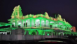 Sri Shirdi Sai Divyadhamam Temple in Nagari. | |
 Nagari Location in Andhra Pradesh, India | |
| Coordinates: 13°19′17″N79°35′08″E / 13.3214°N 79.5856°E | |
| Country | India |
| State | Andhra Pradesh |
| District | Chittoor |
| Mandal | Nagari |
| Government | |
| • Type | Legislative assembly of Andhra Pradesh |
| • Body | Municipality |
| • MLA | Gali Bhanuprakash Naidu |
| Area | |
• Total | 35.45 km2 (13.69 sq mi) |
| Elevation | 115 m (377 ft) |
| Population (2011) [2] | |
• Total | 62,253 |
| • Density | 1,800/km2 (4,500/sq mi) |
| Languages | |
| • Official | Telugu |
| • Regional | Telugu,Tamil [3] |
| Time zone | UTC+5:30 (IST) |
| PIN | 517590 |
| Telephone code | 91-8577 |
| Vehicle registration | AP-03, AP-39 (New) |
| Website | Nagari Municipality |
Nagari is a town in Chittoor district of the Indian state of Andhra Pradesh. [4] It is the mandal headquarters of Nagari mandal in Nagari revenue division. [5] [6]